Earthquake in Alaska

Claudia Ajluni

In the News #3- Lithosphere

This website, Live Science, covers scientific discoveries from a broad range of fields. There are sections for technology, health, earth, animals, etc. so there is a little bit of something for everyone. I chose to look at recent news articles in the Planet Earth section, and found an interesting article from 11/30 about an Earthquake in Alaska. The earthquake was initially reported by the U.S. Geological Survey as having a 6.6 magnitude, but it was later updated to 7.0. The photos of the damage were astounding, and it relates directly to our previous studies about the lithosphere and the causes and consequences of earthquakes. It is much more interesting reading about earthquakes when you have an understanding of why they are happening. The article then goes on to discuss the aftershocks that were occurring in the region and gives an overview of how earthquakes happen. This article is obviously very relevant to what was on our previous test about the processes that take place beneath Earth’s crust. This site was also very informative, and I highly recommend that you guys check it out. It seems to have a little bit of something for everyone, and I plan to explore it later on!

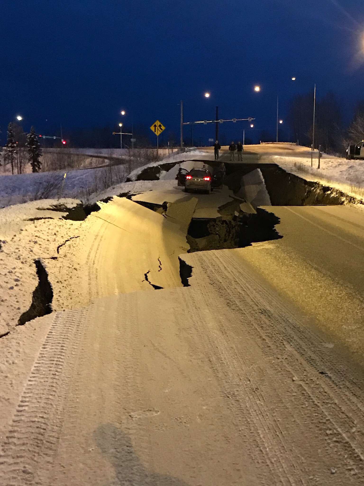
https://www.livescience.com/64206-earthquake-anchorage-alaska.html

Volcanoes: All Day, Every Day

https://www.volcanodiscovery.com/home.html

Volcano Discovery represents a tour company that offers expeditions to observe and study active volcanoes all around the world. However, the site has also come to be a hotbed of information, data, photos, videos, and first-person accounts of recent volcanic eruptions. The page I found most to be the most interesting was the continuously updated and interactive map that tracks all of Earth’s volcanic eruptions, no matter how small. Until I accessed this page I had no idea about the high frequency at which volcanic eruptions occurred around the world.

There is also a page that provides access to webcams depicting live footage of over 200 active volcanoes. Some volcanoes have as many as 37 different feeds (like Mt. Etna, Europe’s largest and most active volcano), while others only have 1, but they all offer a unique look into different kinds of volcanoes, fissures, hydrothermal fields, lava domes, and a variety of other lithosphere phenomena.

Volcano Discovery’s “Photo of the Day,” on 2 Dec 2018. Photographer Ingrid Smet.


Save the Sound

Save the Sound is a website dedicated to the waters of the Long Island Sound in New York and Connecticut. The Sound is an estuary ecosystem with a watershed that extends more that 16,800 square miles into Canada. However, the waters of the Sound face constant pressures from human activity throughout New England and Eastern New York. Save the Sound has been dedicated to the restoration, protection and preservation of the sound for over 40 years. The organization have programs dedicated to stopping pollution, restoring fisheries and habitats, defending drinking water and protecting the climate and air. Every year they have coastal cleanups that engage thousands of citizens to clean up marine debris. Save the Sound is a huge promoter of citizen scientists to monitor water quality and help them with their clean up efforts. Save the Sound encourages individuals who live around the Sound to become members or volunteer to the organization. They also work with schools and other organizations to create fundraisers and organize beach cleanups and educate people about how to help restore the Long Island Sound. Currently, they are working on a project to conserve Plum Island, an island that is the largest site for sea-gulls in New York and a habitat for 220 different bird species. In a 2009 act of Congress the Federal Government decided to put Plum Island up for auction. Save the Sound has gathered over 100 organizations to file a federal lawsuit and stop the sale of the island. Save the Sound is an organization that encourages people who leave near the Sound and use its resources on a daily basis to fight for their land and help restore it. Check out their website to learn about all of the initiatives they have in place to restore and save the Long Island Sound!

Image by Save the Sound

The New York Times: Geography

If you are interested in staying up-to-date on all the news concerning geography, visit The New York Times Geography website. This website is a section of The New York Times providing information and news about geography. It is a great way to learn about recent advancements in geography and read about geographical commentary and archival articles published in The New York Times. This section of the reliable news sources allows visitors to explore various areas of geography. The articles published on this website engages readers by relating geography to everyday life through interactive maps and connecting one’s community to geography. This website, which is a tool for geographers, is integral to understanding the context in which geography is applicable. To find out more about The New York Times Geography, visit https://www.nytimes.com/topic/subject/geography.

Shark Attack Data

Shark Attack Data is a cool website that complies human and shark interactions around the world. It logs shark attacks by either provoked, unprovoked, fatal, or non-fatal. It describes each attack by date, location, type and size of shark, and the activity the person was doing at the time of the incident. The main goal of the website is to increase understanding, and to promote informed discussions on shark attacks. The data comes from the Global Shark Attack File and is compiled by the Shark Research Institute. The website helps you understand where and how shark attacks occur and how they have changed over time on a global scale. You can click on any country to find their statics and data on shark attacks. However, there are some gaps and missing information in some of the logs, but regardless it still provides useful information.


NASA Worldview

Interested in visualizing how the earth has changed over time in terms of sea temperature, air quality, or flood hazard? NASA’s interactive website, Worldview, uses satellite imagery taken over the past 40+ years to help communities visualize the changes that have taken place over time.

Worldview was created using NASA’s Earth Observing System Data and Information System (EOSDIS) to create 800 satellite imagery layers, allowing individuals to view time-stamped changes in critical focus areas such as wildfire management, volcanic eruptions, tropical storms, and more. Layers are categorized based on topic, as shown below. Users can even view layers based on ‘Science Disciplines’– which separates layers into categories such as Atmosphere, Biosphere, etc.


Worldview also allows users to interpret data using different scales! While global data may be valuable for some users, others may benefit from more smaller, more localized scales. Worldview’s zoom capabilities allow users to visualize data from the scale that meets their individual need!

Check out Worldview yourself: https://worldview.earthdata.nasa.gov

Ventusky: Visualizing the Atmosphere and the Hydrosphere

Ventusky is one of my favorite geovisualization websites. Users can select any of numerous physical phenomenon to view in near realtime, from wind gusts to surface temperatures to cloud cover, all with variables for time and altitude. This website serves as an apt companion for our study of the atmosphere and hydrosphere. Most notably, the tradewinds around the equator are often obviously evident, as well as Hadley cells and the acceleration from high to low pressure areas. Also of note, the coriolis effect can be seen if the correct settings are selected.

Ventusky

The Ocean Cleanup – The Largest Cleanup in History

The Ocean Cleanup is an environmental engineering organization that has been designing cutting edge technology for cleaning up the planet’s oceans. Led by 24-year old CEO Boyan Slat, the company has ambitiously focused its efforts on cleaning up the Great Pacific Garbage Patch, a collection of plastic and garbage covering 1.6 million km between Hawaii and California. It is the largest collection of ocean garbage in the world. The Ocean Cleanup is in the process of scaling up their prototype system in the North Sea to prepare it for use in the Pacific Ocean. Once perfected, the system will have the ability to collect trash from the ocean surface and a few feet under water, where garbage ships can come along and pick it up (check out the system in the picture below). At full capacity, the system will be able to remove 50% of the plastic in the Great Pacific Garbage Patch every five years. The website contains information and videos that are extremely helpful in understanding the technological development process and current stage that the company is at in getting the system fully operational. The cool thing about the website is that with the technology it displays being so revolutionary, the site truly allows you to see history unfolding before your eyes! You become a spectator of how an innovative group of people is making an impact in restoring our planet’s oceans closer to their natural state.

“Up in Smoke: The pros and cons of burning rubbish” : Madison Sweitzer

Photo from The Geographical 

An article from The Geographical, the official magazine of the Royal Geographical Society. In London, they are currently burning 53% of trash, which is an amount that has almost doubled in the last decade. The British government is looking to cut down on the amount of burned trash, and the Treasury has announced that it now is considering imposing a tax on the incineration of waste, creating an active opposition to what was originally thought of as a favorable alternative to adding waste to landfills. One positive of the burning trash is that it can be used to generate steam energy, and it lowers the physical amount of trash in landfills. However, opposition to this process critiques that incinerating plants have never been required to report particulate emissions in enough detail to moderate the potential health impacts. The plants are also contributing to greenhouse gas emissions, with approximately each ton of waste burned adding one ton of carbon dioxide to the atmosphere. The last critique is that increasing incineration may decrease motives to recycle. Although the negatives appear to outweigh the positives, this situation does demonstrate the importance of trying to best consider all components of the Earth when making environmentally-conscious decisions. By this I mean that in this instance it appears that the damage to the atmosphere would outweigh any benefit to the biosphere of less physical trash, but it is important to assess both. This article relates to our discussion of climate change in class, and specifically how humans may be contributing to it, through greenhouse gas emissions such as this. It also introduces the political component of addressing climate change, such as the tax considered in this article, and how that may help to combat the further damage.


Article Source