Geography in Linguistics: Regional Dialects

We’ve all disagreed with a friend or two about the pronunciation of a word at one time or another. Language, however, is more than a function of history. Geography has a major impact on the lexicon an area uses. By affecting a number of linguistic components, including lexicon and accent, geography plays a major role in developing regional dialects. While looking around various social media sites, I stumbled across a website that lets you explore such questions as “Am I crazy for pronouncing caramel as ‘car-ml’?” and “Why does Jimmy use ‘you guys’ even though Helen uses ‘you guys’? They’re both from Florida!”

caramel


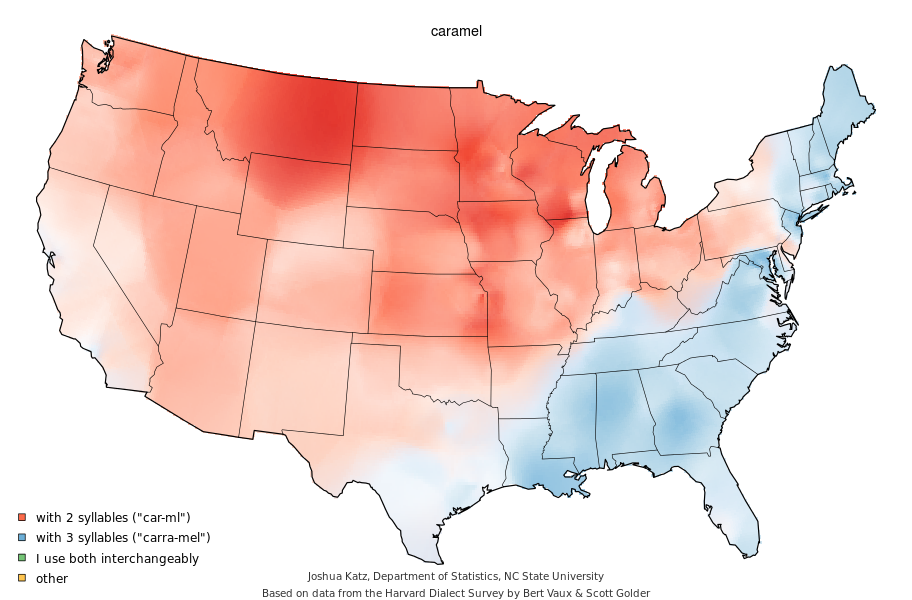
Constructed by Joshua Katz at North Carolina State University, the series of maps illustrates data collected during the Harvard Dialect Survey conducted by Bert Vaux and Scott Golder.

yall

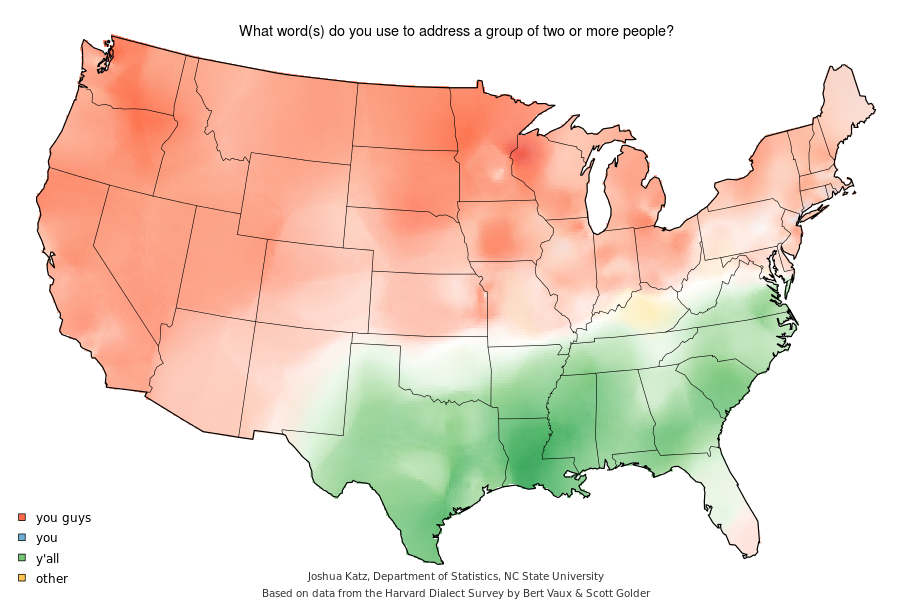
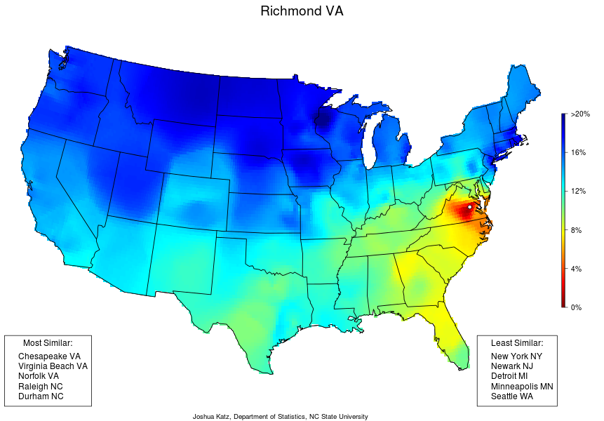
Found on spark.studio.com (at http://spark.rstudio.com/jkatz/SurveyMaps/), this set of data offers over one hundred individual maps relating to regional dialects in the United States. They include the pronunciation of individual words, usage of various phrases, and regional names for objects and activities. Further, it notes the most and least similar cities to the selected option. Additionally, the site allows filtration of data maps answering individual questions on city, static, and ‘click’ levels. In addition to the various maps created using geographic information systems (GIS), this site hosts a number of interesting links that allow you to personally relate to topics in geography related to linguistics. The primary links related to personalizing the experience are a quiz that allows you to discover what kind of dialect you have and an aggregate map of dialect differences (http://spark.rstudio.com/jkatz/DialectMap/). This set of maps displays the level of similarity between areas based on the one hundred and twenty two questions asked in the survey. Further, it notes the most and least similar cities to the selected option.

richmonddialect

Though the site does not specifically relate to physical geography beyond highlighting the various tools a geographer may use, such as GIS and survey for data collection, the maps indirectly highlight the historical and cultural significance of major land forms in the United States. For example, the use of terms to refer to a group of two or more people changes with the region, indicating that the dispersal of individuals spatially altered the lexical preference of individuals. Further, mountain ranges appear to impact specific questions, suggesting that physical barriers may have influenced dialect usage. Rivers and bodies of water interact with aquatic transportation in a similar manner, acting as connecting forces for regional dialects.

I find this site particularly interesting because it uses various tools of the geographer in an interesting way that engages individuals from around the United States. It applies spatial analysis to a language, inviting people from a number of backgrounds to the conversation. It acts as an engaging tool for people of all ages and backgrounds interested in comparing aspects of regional dialect.


Discover The Forest

I discovered this website when I read a PSA aloud for the US Forest Service on my radio show. When I eventually visited the website, discovertheforest.org, I found it to be a great resource to connect people with forests near them.

11111414_1571827483065639_947258725_n

You can locate forests near you using your zip code, and filter sites based on types of recreation and type of site (national forest, wilderness area, etc.) I mapped locations for the 23173 zip code, and had 20 forests to choose from!

Screen Shot 2015-04-25 at 12.00.25 PM

Along with providing resources for recreational opportunities, Discover The Forest provides information on conservation information and how people can take action by volunteering with the US Forest Service or another organization.

What makes this website particularly interesting for me is how people’s recreational interests can overlap with conservation and education. It’s the best of both worlds for people and nature when these two lines of interest intersect. I work for the Appalachian Mountain Club doing trail work over the course of the summer, so I often see first hand how recreational experiences go hand-in-hand with stewardship. Also, many people may be unaware of the many natural areas that surround them, and this website provides a way for people to engage with the outdoors in the digital age. Children especially could benefit from putting down a game console and picking up a fern, am I right?

fern


So go forth! As I say in my PSA: Unplug. Reconnect. http://www.discovertheforest.org

NASA Journey to Mars

NASA Journey to MarsNASA has a dedicated section on its site for the Journey to Mars initiative. The ambitious plan has two goals: send humans to an asteroid by 2025 and to Mars in the 2030’s.

But why do we need to go to Mars anyway?

Mars is a comparable planet to Earth that once had conditions suitable for life. Exploration to Mars could help answer the age-old questions that get the blood rushing for astronauts and astronomers everywhere: Is there life beyond Earth? Are we alone?

To prepare for this journey, astronauts on the International Space Station are testing technologies and communication systems to make the mission possible, as well as collecting data about how the human body responds to living in space.

NASA will then move into deep space by capturing an asteroid, redirecting it to orbit the moon, and sending astronauts to explore the asteroid on the Orion spacecraft in the 2020’s.

Orion is designed to take humans deeper into space than they have ever been before, including Mars. It will be launched into space on NASA’s new heavy-lift rocket, the Space Launch System. Orion has already been built, and it even completed a successful flight test in December 2014.

NASA's Orion spacecraft awaits the USS Anchorage after a successful flight test on December 5, 2014

There is already a fleet of robotic spacecraft and rovers collecting data on Mars, and in the future, the Mars 2020 rover will seek signs of past life.

Engineers and scientists throughout the world are working with NASA to develop the technologies necessary for traveling to Mars and then living and working there before returning safely home.

The Journey to Mars section of NASA’s website includes the following sub-pages: Orion Spacecraft, Space Launch System, Ground Systems, Asteroid Redirect Mission, Robotic Mars Mission, International Space Station. There are also tabs for: Images, Video, and Media Resources.

http://www.nasa.gov/topics/journeytomars/index.html 


Spatial History Project

I looked at Stanford’s Spatial History Project Website, which shows the research that students and faculty at Stanford have done that integrates spatial data into a variety of disciplines.  The stated purpose of the website is to engage in creative analysis to further research in the humanities.

This website does a fantastic job of using geographic analysis for a plethora of different projects, from production of space in mining in the 1890s to a comparative study of the Salmon flu over time.  One of my favorites is the conservation history of California.  This map combines several viewpoints of conservation history in the Bay Area.  The way that priorities of conservation in the area have shifted is really interesting.  The website is intended for an academic audience, which makes it less accessible to the general community, but the objective is really cool.  Looking into the way that historical phenomena occur over space definitely provides a fresh perspective for further research and inspiration for future mapping projects.  http://web.stanford.edu/group/spatialhistory/cgi-bin/site/index.php

GreenMaps

GreenMap motto is to “Think Global, Map Local”. The website promotes participation in sustainable community development in an inclusive manner. On the website, you can find over 800 maps of cities what show a wide range of sustainable related activities and places. These can include public green spaces, local farmers markets, organic local restaraunts, local bike shops, environmental NGO offices, environmentally related government offices, and many more.

Through their maps, GreenMaps hopes to increase local-global sustainability networks, strengthen the demand for healthier and greener consumer choices, and help green initiatives spread to more communities.

I checked out one of their open-source maps for Richmond and found an interesting variety of green-related items: http://www.opengreenmap.org/greenmap

MAP

On the map, there are a few obvious green related things, such as Monroe Park. But there is also some less well-known items as well. Some notable ones were one of the VCU dorms. It was highlighted because the entirety of the perimeter of the dorm is planted with vegetation to help filter the storm water runoff from the dorm. Another cool feature on the map was a fix-it-yourself bike repair station located on the VCU campus.

You can also add your own features to the maps as you see fit.

In general, this website is a great way to get better connected into local sustainable activities and initiatives. This website could be especially helpful to help you get acquainted to a new city or new community.

I think this website can really help create a stronger sense of place in communities.


MyWATERS Mapper

http://watersgeo.epa.gov/mwm/

Curious about the water quality of streams and rivers near your house? Check out this website! MyWATERS Mapper shows snapshots of waterways right from the Environmental Protection Agency Office of Water program data. This website contains huge databases of information just a click away on an interactive map: the status of the National Pollutant Discharge Elimination System (NPDES), which is a program established under the Clean Water Act that controls water pollution by regulating point sources in the United States for each State; information from the Clean Watershed Needs Survey, which is a comprehensive assessment of the primary needs of waterways in order to meet the water quality goals laid out in the Clean Water Act; and finally, water quality assessments of nutrients, sedimentation, and pathogens levels.

I looked up a stream near my house in Philadelphia called Neshaminy Creek (Neshaminy was once a Native American tribe in the region) and discovered that it has a sedimentation problem from a non point source (which makes sense if sedimentation is caused by runoff). I was also able to observe other streams in the area and where they drained into the Delaware River, which is the receiving water body for most of the waterways in the region. The website even has downloadable data and enables you to create customized maps at national and local scales. One feature that would have made this website even better would have been a “watershed” layer that shows the watershed each waterway is part of. Another possible improvement would be to integrate this map with USGS databases on the peak stream flow, daily discharge, and flood frequency of waterways throughout the US. It would be interesting to investigate how these aspects compared with sedimentation TMDL or non point source pollution.

-Don Edmonds

GeoGuessr

https://geoguessr.com/

This website shows you the world, but doesn’t tell you where you are. GeoGuessr is a geography game that uses Google Street View to put the player in a completely random location somewhere on Earth, and then asks you to guess your location based on your surroundings. Sometimes clues can be found in the language on street signs, but more often it is left to the player’s knowledge of geographic and biotic features, like mountains or vegetation. The game takes you to five locations around the globe, and you use a world map and a pointer to submit your guess. Points are assigned based on how close your guess was to the actual location.

This game helps people learn how to identify geographic features, and how to observe the world around them for such features. The beautiful locations keep the average player engaged while also showing what makes a place memorable and identifiable. It also gives more experienced geographers a chance to test their skills. I would classify this site as a Tool of the Geographer, for both its educational and testing value.


GeoCurrents

http://www.geocurrents.info/

This website has a wide variety of current events articles all pertaining to geography.  Different categories include cartography, cultural geography, physical geography, and population geography.  The website is also organized by region.  All articles are written by Martin W. Lewis, a former professor of geography and senior lecturer at Stanford University.

Each article includes historical background, regional analysis, and political context.  Rather than simply retelling the story, Lewis provides a background to better understand the geographical references.

There is a secondary section of the Geocurrents website, which includes shorter articles that focus on specific maps.  The site also includes an events map, highlighting noteworthy topics across the world.  On the map there are different categories pertaining to different current events.

Each article is analyzed without being biased and without a predetermined position on the topic even though the topics may often be controversial.  They encourage input from their readers and enjoy hearing readers’ opinions.  They pride themselves in their ability to analyze current geographical events with impartiality.


Geology Website

As soon as I went onto this website, I was bombarded with a vast array of information about geology and environmental studies. I recognized many of the topics as ones we had learned about in class. You can see its wide array of topics, located on the left sidebar, here:

Home Page


There is a lot to explore, too much to cover in this post, and some of it is geared towards teachers looking for ways to teach these lessons to their students. Nonetheless, it is still useful for those who are not actually teachers. All of the posts I saw had pictures and/or diagrams, with detailed yet simple explanations illustrating concepts. Below are a couple of posts about concepts that should look familiar to all of us.

Metamorphic Rocks

Plate Boundary


I like that no matter the topic, whether it is metamorphic rocks or plate tectonics, they have detailed examples and differentiate between the types of examples in each category.

When I first came upon the site, I was a bit concerned about how all of this information could be legitimate. But after doing some research, I saw that it was founded by a licensed geologist named Hobart King. Once Dr. King retired from teaching at a university, he devoted his efforts to this site. Other contributors also are in the geology field, and from what I saw, their names and credentials could be seen at the bottom of each of their articles.

I suggest going and exploring it! I was on it for quite a while and probably only covered a small percentage of what the site has to offer.

http://www.geology.com/

The Daily Climate

http://www.dailyclimate.org/

This website is dedicated to informing the public about climate change, its impacts, and any new or existing solutions.  The Daily Climate pulls from many different sources to consolidate news and information about climate change all in one place.  The email list sends a concise list of climate-related news events that have happened recently, in an unbiased and informative manner.

Screen Shot 2015-04-23 at 12.56.39 PM

There is a lot of news from domestic and international sources that give the reader a big-picture view of the progress the world is making as a whole to stop the effects of climate change.

The authors of these articles are most often scientific writers with a history of environmental journalism or climate science.  This offers The Daily Climate credibility to their publication as the information they present is going to be well documented from reliable sources that know what they’re talking about.

For anyone seeking information on climate change and the science behind it, the Daily Climate is the first place they should go.  Deniers and believers alike can use this source to better inform their life decisions and take action to help save the Earth.


PS. check out how relevant the first article on the website is: http://mashable.com/2015/04/22/forests-artificial-intelligence/

Screen Shot 2015-04-23 at 1.07.07 PM