Cape Wind: America’s First Offshore Wind Farm

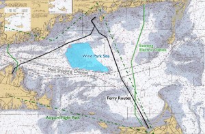
The Cape Wind project is a plan to construct a wind park about five miles off the coast of Cape Cod, Massachusetts. The park would be located in a region, Horseshoe Shoal, with strong, consistent winds, and far enough away from shipping and commercial boat traffic. The 130 turbines would be nearly silent from close distance, not audible at all from land, would not affect telecommunications and will include safety lights. It would produce an enough electricity to satisfy about 75 percent of the energy needs of Cape Cod, Martha’s Vineyard and Nantucket. Supporters of the project claim that the project will help produce cleaner air and lower greenhouse gas emissions, help make the country more energy independent, lower energy costs, and create thousands of jobs (both long- and short-term).

Most opponents, while supporting sustainable energy in theory, claim that Cape Wind would simply be located in the wrong location. Critics have stated the the project could diminish real estate costs, harm birds, destroy the fishing industry that relies on Nantucket Sound and ruin the aesthetic appeal of an otherwise untarnished horizon over the beaches of Cape Cod.

Opponents have also stated the leaders of the project are more concerned with ecotourism than with producing sustainable energy. Leaders of the project seem to be of the same mindset as Stephen Mather, the first Director of the National Park Service, who was concerned with bringing people to national parks, not merely with conservation. The project is still in the process of being approved, but it will take leadership that can unite the interests of all invested parties in order for it to succeed.

Here are computer simulations of how the wind farm would appear from the coast. Do you support or oppose Cape Wind? How can all interests be reconciled so that the project can begin?

NatGeo and National Parks!


This is an image of Yosemite Creek in Yosemite National Park, USA.

You may associate National Geographic Magazine with long waits at the dentist's office or elementary school required reading, but everyone's second favorite dentist read (second only to "Highlights Magazine" of course), has undergone a high-tech turn for the better.  The National Geographic Society still prints the original magazine that many of us are familiar with today, but since our days as elementary school students the Society has expanded its offerings to include a television channel (Nat Geo TV), website, and several other magazines focused on travel, children, and young children.  On NationalGeographic.com, there are hundreds (maybe thousands) of tabs and links with everything from maps to trip ideas to current events.  With webpages, photographs and video links on photography, animals, the environment, space, science, travel, adventures, and Current Events, and with astounding images that capture life in some of the Earth's most exotic locales, there are countless topics to explore and places to learn about. 

In honor of "Park Week," which was this past week, and our class's focus on the National Park System, I've highlighted a subset of the National Geographic website that focuses exclusively on National Parks!   This page has park guides, amazing photographs, a history of the national park system, and even an interactive tool that allows you to test your knowledge of specific parks by taking one of National Geographic's national parks quizzes!  Take this one on Glacier National Park (I'm a bit biased).  What have you learned about this or any national park that was presented in class that you didn't know before?

Google Earth Engine: A GIS tool for tropical forestry at a local scale!

Check this out! Google Labs is working on a new application -different from Google Earth- that will make GIS more accessible on a local scale. Watch the first video “What is Google Earth Engine?” If nothing else it will demonstrate the importance of GIS within environmental initiatives.

What they’re developing is an online cloud computing platform environmental monitoring program with landsat imagery of tropical areas updated daily, giving countries access to the most current data about their forests. They do offer a few maps and data sets to look at, but the program is definitely still in the works! The expectation is that local places will be able to accurately observe and report on the changing state of their land. They hope that over time this program will help reduce tropical deforestation, empower developing nations, and contribute to a better public understanding of the planet resources! There’s a second video on the site listed above that explains the Surui tribe’s Carbon Project in the Amazon!

What is Google Earth Engine?

Redwoods: A History

http://ngm.nationalgeographic.com/2009/10/redwoods/redwoods-interactive

Ever wonder all of  the history and important dates and events the giant redwoods have been alive to witness, well on the National Geographic Interactive website you can do just that.   This website created a time line of one redwood tree using its tree rings and shows the huge length of time these trees have been alive, the tree they focus on has been alive  since around 1180!    These trees have been alive throughout major points in history like the Magna Carta being signed in 1215, Christopher Columbus’ journey to the Caribbean in 1492, the American revolution of the 1770’s, the founding of the national parks in 1872, and natural disasters like Hurricane Katrina in 2005.    This website also maps these huge giants along California’s coast and shows  two National Geographic employees journey through the forests, which lasted a year.    The final part of the website, and one of the most interesting pats, is the the focus on the canopy ecosystem of these giants, which is rarely accessed and studied.    Hundreds of feet up in the air on the branches of the giant redwoods, thrives an usually unseen ecosystem, full of plants and animals, including berry bushes and ferns as well as the Marbled Murrelet an endangered bird, salamanders, and chipmunks.   Over the years soil has formed on these huge redwood branches, and in some cases this soil is up to three feet deep, which allows for the thriving ecosystem up in the trees.   This National Geographic Interactive web site is a great tool to learn about the giant redwood forests, see all of the history these trees have witnessed, and get a glimpse at an ecosystem that few see and study.

MapMaker Interactive

This website is an interactive tool that allows you to view various criteria for different regions of the world simultaneously, along with being able to edit the map with markers and drawings. Though it is similar to ARCGIS software, this interactive map from National Geographic makes for a fun mapping experience. The criteria to view are grouped by categories including Physical Systems (land, water, climate), Human Systems (Populations & Culture, Political & Economic), and Environmental and society. The coolest thing about the map is being able to view multiple criteria at once, so for instance being able to see the human footprint of a region overlapping with volcanic eruptions to see if there is any correlation between the two. The drawing tools can be extremely useful, especially for measuring distances. If you select the ruler tool you can click between two points to measure the distance in km or miles. A variety of map modes are offered to view including terrain, topographic, satellite, streets, national geographic, and outline. All in all, this site is a great tool for geographers of all ages looking to explore different statistics and features of the world.

Check out the tool at http://education.nationalgeographic.com/education/mapping/interactive-map/

Future farm: a sunless, rainless room indoors

As we are moving into the topic of biosphere, we have been discussing factors that influence the growth of trees: temperature, rain, soil, sunlight, etc. We see a clear connection between physical geography and biomes i.e. how one affects the other. In addition, most of our NPS presentations touched on the effects of physical changes – atmosphere, hydrosphere, and lithosphere – on a local species.

It is, however, very interesting to read about the indoor farming. This idea has been created and experimented by a Dutch bioengineer, Gertjan Meeuws, in Den Bosche, the Netherlands. What he is doing does not support what we learn from class, but is very thought-provoking: what kind of conditions can we control to be able to grow plants indoor?

Certainly, this method requires good combinations of light, soil, humidity, and temperature. This is different from the greenhouse conditions because natural sunlight is excluded. However, Meeuws claimed that the growth rate from this method is three times faster than under greenhouse conditions. This method requires LED bulbs which can be expensive, but the cost is getting lower nowadays. Moreover, the indoor farming does not need pesticides, and requires about 90 percent less water than outdoor agriculture.

Other benefits from this way of farming is that it may be one of the answers to the world’s food problems. Food prices are unstable because the climate conditions are uncontrollable i.e. floods, droughts, etc. Not only do we face the price problems, but the limited resources are also challenged by the growth of population. The United Nations predicts that, by mid-century, the world population will increase from 6.8 billion to 9 billion. To feed so many people we expand farmlands at the expense of forests and the wilderness, we also increase crop yields in artificial and radical ways. But, indoor farming is a great alternative to respond to more food demand. It is even possible where farmland is scarce like in a city. Since half the people on Earth lives in cities, it would be a good idea to grow some plants in cities to reduce the transportation cost, especially when the oil price is rising steadily.

source: http://www.seattlepi.com/news/article/Future-farm-a-sunless-rainless-room-indoors-1331582.php

Of Wildebeests and Highways

This semester we’ve come in contact a few times with wildlife corridors, including one of our guest lectures and the Y2Y corridor. We talked about the importance of them and the importance of conserving areas for wildlife in a rapidly changing landscape. This website, Serengeti Watch, provides insight to a threatened wildlife corridor that could have a huge impact on the livelihoods of many and the success of Tanzania as a country. The government of Tanzania is acting on a highway plan that will cut straight through Serengeti National Park, one of the largest wildlife corridors in the world and a home to the largest migration route for countless species including the wildebeest and zebra. As we know, the disruption of habitats through land use change can lead to extinction, island bio-geography, and edge effects among many other detrimental issues. This website provides a way to learn about the vast impacts of the highway and advocates for the “alternate route” to the south. While President  Kikwete argues that the highway will provide economic success on a local and national level by connecting rural villages and allowing for more goods and services to pass through the area, the Serengeti draws in millions of tourists which greatly add to the national income. This website provides many news articles both for and against the highway and provides links for users to take action. It keeps up to date news stories and developments on the issues and is a great educational resource for the highway debate. It looks at the challenges and impacts of the near future as well as the far off future, as well as addressing the impacts through many scopes. The loss of this corridor could mean the deaths of several thousand wildebeest alone. Save the Serengeti provides a current example of the threats to wildlife and wildlife corridors because of human impacts. Its definitely an interesting topic and debate as to whether the needs of humans and wildlife can/must be compromised, definitely an interesting topic!

http://www.savetheserengeti.org/issues/stop-the-serengeti-highway/#axzz1Jo2KvJCI

Gulf Life – Interactive Graphic

The National Geographic website has a new interactive feature on life in the Gulf after the oil spill.  The graphic first allows users to select a layer of life that includes: the coastal ecosystems, bright surface, twilight zone, and dark and teeming.  Once a user selects the layer they prefer, the site opens up a new picture depicting the different forms of life found in this layer.  The user can then select the different plants and animals that live in the chosen layer, causing a description to pop up about its impact on the region and general information on the species. The site allows the user to learn about the different plants and animals that live in the gulf–many of which the average person is not familiar with.

The neat aspect of this interactive map is that it not only gives the user an in depth look at each layer of life, but it also shows how different specifies continue to be affected by the oil spill.  The site states that the golf oil spill has, “tested nature's resilience at every layer.”

While the disaster occurred many months ago, the impact on the biodiversity of the region continues to be seriously harmed.  It was the largest marine oil spill in the history of the petroleum industry and plants and life forms are still recovering even almost a year later.  Many people in the region rely on the productive biodiversity for economic reasons, as thousands of fisheries going out of business.  The Gulf Oil spill was something we should never forget, and this interactive map reminds us of how diverse the region is, hopefully leading us to find other places for deep water drilling.

Enjoy the link below to explore life in the Gulf!

Gulf life Interactive Graphic

Environmentally Friendly…Golf?

After watching the Masters Tournament held at the Augusta National Golf Club and being an avid golfer myself, I wanted to research to what extent golf courses around the world require vast amounts of water, fertilizers, and pesticides, and how badly they are harming our environment.  I quickly came across an article from National Geographic titled “Golf Masters Green–Ten Environmental Courses” that does not so much address the negative effects of this, but focuses on a shift in practices.  While golf courses have been detrimental to the well-being of our environment, there are efforts being made to help golf earn a greener reputation, as the article says.  Consumer consciousness about sustainability, an economic recession, and new technologies in turfgrass, sprinkler systems, and carbon-neutral engineering are all helping the cause.  The amounts of water, fertilizers, and pesticides that the featured golf courses consume have undoubtedly been ridiculous, but it is interesting to read about the measures being taken to curb the negative impacts this consumption has had.

Definitely check out the website, whether you’re a golf fan or not.

http://news.nationalgeographic.com/news/2011/04/pictures/110408-golf-masters-green-environment-courses/#/golf-environment-augusta_34373_600x450.jpg

Monster in Lake Baikal

As we have learned in class, Lake Baikal is the largest lake in the world; it is home to many species of plants and animals. This site explains why it is no surprise that a possible lake monster resides somewhere in the depths of this enormous freshwater lake. There have been many eyewitnesses to what is described as a “sturgeon-like monstrosity” with a cross between a seal-like mammal. Some theories of origin include the land locking of the beast within the lake as a result of the last ice age, possibility of a sea-serpent swimming up one of the many rivers or streams that feed into Lake Baikal, or the most popular of all theories, a remarkable mutation caused by the pollutants released into the Lake. The Baikalsk Pulp & Paper Mill is the largest contributor of pollution into the lake, this company “has dumped approximately 210,000 cubic meters of untreated waste into Lake Baikal every day since 1966.” Though scientists have not been able to apprehend and study this unknown monster, the possibility of its existence is highly likely since the bottom of Lake Baikal has not been explored to this day, which may contain many undiscovered species.

http://americanmonsters.com/site/2010/01/baikal-lake-monster-russia/