Mapping the Last Mountain Range on Earth

Ice Stories: Dispatches from Polar Scientists provides a fascinating look into the research and expeditions of scientists in both the Arctic and Antarctic environments. The website consists of dispatches from all kinds of scientists: glaciologists, geologists, cosmologists, and even penguin biologists. The site includes profiles of over 25 scientists that detail their perspectives on various projects being conducted. While the site is somewhat dated (the last entry appears to be from 2010), it is nevertheless an amazing window into the actual research that occurs at the poles and all the fields of study to which the research contributes. A visitor can browse through entries by tag, month and year, or even look at pages for specific projects and big ideas such as ice, climate change, and astronomy in Antarctica. There are also links to webcams in Greenland and the South Pole that show each base and the weather conditions at the station.

One of the entries that caught my attention was the mapping of Antarctica’s Gamburtsev Mountains, which lie hidden underneath the ice in the middle of the continent. The scientists involved in this mission in such an unforgiving environment hoped to find clues to the formation of Antarctica itself and consequently the climate experienced on Earth today. Survey aircraft used RADAR and lasers to see through the thick ice sheet and get a glimpse of the range beneath. Other scientists used seismographic equipment to track the effects of earthquakes around the globe, ultimately hoping to discover the source of the mountains – could it be the collision of tectonic plates, or hot plumes coming from the ocean? Find out on Ice Stories.

Bird Migration 2017

I found a website that has looked at the bird migration in each region of the United States and is tracking their movements. For each region, they have multiple charts with specific birds to see which ones have been moving more in the past week, and which ones have been moving less in the past week. It would be cool to go on this website for a whole year and see what birds migrate at different times, and how consistent this timing is over the years. There is also an animation that basically shows bird migration over the past few months.

Within this website, there is an interesting link that further expand upon bird migration. This link defines each region (i.e., what states are in each region), and then talks about when they would expect bird migration. It talks about when you would expect the species to arrive first, then when the number of birds arriving would begin to increase rapidly, when the number would peak, when they would start to leave, and when the final bird would leave. This website is relatively new (created in 2015), so I’m not entirely sure how accurate these predictions would be, but nonetheless it is still interesting.


link: http://birdcast.info/forecast/regional-migration-analysis-10-17-november-2017/#MidwestNortheast

UNESCO Biosphere Reserves

A view of the Chihuahuan Desert, situated in parts of western Texas and Mexico. Three biosphere reserves are located in this desert.

The United Nations Educational, Scientific and Cultural Organization (UNESCO), famously known for their World Heritage Sites, also has an extensive biosphere reserves program, established under the umbrella of their Ecological Sciences for Sustainable Development department. These biosphere reserves are internationally recognized conservation zones found all over the world, incorporating marine, coastal, and terrestrial ecosystems. In addition to functioning as conservation zones that preserve biodiversity, these biosphere reserves also serve as areas for scientific study, particularly in the fields of sustainability, ecology, and human development. To ensure that these biosphere reserves are properly functioning and effectively managed, UNESCO conducts a periodic review process every ten years to ensure that each reserve measures up to the international standards.

Biosphere reserve in Cuba.

This website provides an overview of biosphere reserves and their mission and lists each of the 669 biosphere reserves around the world, first by region and then by country. Here is the list for Europe and North America, and here is the list specifically for the United States. UNESCO’s biosphere reserves website relates to our class discussion of the biosphere and the importance of biodiversity in maintaining healthy ecosystems. As climate change intensifies, we see a greater need for the creation and maintenance of conservation zones like UNESCO’s biosphere reserves. However, this website also reveals that this needed maintenance is in fact not occurring. Unfortunately, in 2017, twenty biosphere reserves were withdrawn from the global list, seventeen of which were in the United States alone, and all of which were withdrawn because of their poor performance in UNESCO’s periodic review. This raises important questions about our national and global priorities for the future of such important biosphere reserves. Will we make preserving biodiversity through biosphere reserves and other forms of conservation a priority? Or will we continue to let vital ecosystems in our biosphere flounder and disappear?

Gorillas and Vegetation in Africa’s Oldest National Park

Analyzing the Distribution of Vegetation Zones and Mountain Gorillas in Virunga National Park

Mountain Gorilla

How are abiotic factors, vegetation zones, human activity, and distribution of mountain gorillas linked?

On National Geographic’s Website (https://www.nationalgeographic.org/activity/analyzing-distribution-vegetation-zones-and-mountain-gorillas-virunga-national-park/), there is an interactive activity in which scientists and geographers analyze Virunga National Park along the eastern edge of the Democratic Republic of the Congo along the Mitumbar Mountains. It is the oldest national park in Africa. The geography of this park ranges from grasslands and wetlands, to lava plains and natural glaciers, and is home to various species (nat.geo.org/mapmaker-abiotic-factors-virunga). 

The national park was designated in order to protect these mountain gorillas. They are omnivores but usually have plant-based diets. “Poaching, encroaching human populations, and violent conflicts in the area continue to affect mountain gorilla populations” (https://www.nationalgeographic.org/activity/analyzing-distribution-vegetation-zones-and-mountain-gorillas-virunga-national-park/ ). Illegal timber cutting is also becoming a big issue in the area. This is mappable from the site.

This Website shows the change in vegetation and gorilla populations in the National Park as a result of human activity. This relates to physical geography because it connects the lithosphere and biosphere between the national park territory and anthropocentric effects.

With a rise in populations it is more imperative now that people are made aware of the changes this ecosystem is experiencing due to selfish and illegal activity on supposedly-protected lands.

Website; https://www.nationalgeographic.org/activity/analyzing-distribution-vegetation-zones-and-mountain-gorillas-virunga-national-park/


National Geographic Encyclopedic Entries

The National Geographic encyclopedic entries page is a really useful tool for our Physical geography class since it provides various entries on class related concepts like hot spots, El Nino, earth’s crusts, continental drift, etc. It’s really easy to use, you can either enter the topic you are interested in looking for or just scroll down the pages looking for it. Each entry provides a set of images, definitions, animations, videos, background information, related material and even useful sources that connect to other articles about the subject.  There’s even a complete vocabulary tap that expands on explaining each key term’s definition and use. This would be a really useful tool to study for our final exam since you can search in a more interactive way concepts that you feel you need to look up more information about.

https://www.nationalgeographic.org/encyclopedia/

The Restoration of Sequoia National Park’s Giant Forest

There’s a section https://www.nps.gov/seki/learn/historyculture/gfmain.htm on the National Park Service’s website that discusses the restoration of Sequoia National Park’s “Giant Forest,” which contains one of the largest groves of the “[a]we-inspiring” sequoia trees that are found only on moist areas along the western slope of the Sierra Nevada mountain range. This site gives a brief overview of “giants'” decision to commence the Giant Forest restoration project and of the goals of the project, then gives, at the end of the page, links to pages with before-and-after photos, descriptions of visitors’ experiences, information regarding the impact of human development on the area, and information regarding the natural ecosystem of the Great Forest and the successful restoration of the area’s soil and vegetation. I thought the before-and-after photos were particularly interesting because they illustrated just how much has changed since the commencement of the project in the late 1990s. The site said that since the project began, 231 acres of land have been restored and 282 buildings have been demolished (and the few visitor facilities that remain have been converted into buildings that can only be accessed/used during the daytime), but a picture is worth a thousand words. The before-and-after pictures illustrate just how much natural beauty human encroachment/development/influence robbed the forest of.

While the Giant Forest was saved from the devastating effects of logging when it was designated part of Sequoia National Park, the effects of human encroachment were still seen in the changed drainage patterns, the clearing of trees, and the depletion of topsoil organic matter. The Giant Forest was in desperate need of restoration, and thankfully, the restoration project started in the late 1990s was a resounding success in that it both achieved its original goal — to restore the natural landscape — and it demonstrated just how large an impact a group of dedicated conservationists can have.

Oxbow Lakes

The website ThoughtCo. offers various articles on multiple subjects, including physical geography, political geography, urban geography, climate, etc.  Their goal is to provide resources for students and teachers of geography through articles, images, maps, etc. that explore these various topics within geography.  One article within the category of physical geography explains oxbow lakes.

https://www.thoughtco.com/physical-geography-4133032

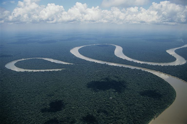
Oxbow Lake beside the Amazon River

Water in rivers flows faster on the outside of its curve than it does on the inside.  This creates erosion and decay that does not happen on the inside, creating the final curved shape.  The neck of the loop eventually erodes to the point of cutting itself off from the main river, creating the separate body of water known as the oxbow lake.  Oxbow lakes can also be initiated by humans in order to meet navigational needs.

Oxbow lakes are bodies of water that are cut off from the river in which it began.  They are unconnected but still close by since they were originally part of the river.  Oxbows get their name from the bow-like appearance of them, due to the nature of rivers’ curvature.  The water in these lakes no longer flows, but relies on precipitation, sometimes just becoming swamps.  Due to lack of outside water, these oxbow lakes often evaporate entirely within a few years of breaking off from the river.  As climate change continues to rise, these lakes will evaporate at faster rates.  This reinforces the rising issue of water scarcity and the impact that humans have on it.  In the United States, Oxbow lakes can be found along the Mississippi River and in Crater Lake, Iowa.

How Wildlife May Fare Under Trump

Link to the article: http://news.nationalgeographic.com/2016/11/wildlife-watch-trump-wildlife-trafficking-animal-conservation/

Since the recent presidency elections one of the major questions was about, what would Trump do for the environment? If he becomes the president-elect. The debates in this presidency election surround various of concerns, including some which focus on national security, trade, economics, and to a lesser degree in this election cycle, on the environment. Wildlife, however, plays a part in all those concerns.

“Given our demonstrably disastrous effects on wildlife, there is now recognition that humans have a certain obligation to protect wildlife for its own sake” (Rachel, Jani, 2016). Since 2013 president-elect Obama has worked greatly on the conservation and sustainability of nature and protection of wildlife besides that we even worked on reduction of the pollutants which effects the earth and its climate. Which shows the attempt by the president to really protect the environment for a better and sustainable future.

However, the concern now rises what is the new president-elect going to do for the environment, as some of his campaigns seemed to promote the idea of climate change being a hoax rather a real problem which deserves concern. Trump’s administration seems to promote trophy hunting and other unfriendly- environmental amendments which, may cause a disruption through out the ecosystem, especially the hydrosphere, atmosphere, and biosphere. Besides, the wall which Trump plans to build is going to disrupt the ecosystem especially the biosphere as its going to hinder animal migration which might end up being a cause for the extinction of these animals.

Stanford University Spatial History Project

The Spatial History Project is an attempt to conduct research within the humanities, specifically history, through the lens of spatial analysis. The team compiles both spatial and non spatial data together within geospatial databases. The differentiation between the Spatial History Project and traditional history research lies in several factors, including the fact that it places a strong emphasis on visualization, a conceptual approach to space, is more collaborative and depends heavily on the use of computers. The website allows you to access the research put out by the Project, as well as look at current projects. Some projects that are currently underway include A Chronology of Suburban Expansion for San Antonio, TexasA Global Atlas of OilFollow the Money, and From Forest to Vineyards: The Changing Landscape in Brazil, among many others. All of these projects begin by examing a central historical issue, and then trace itsdevelopment using geospatial methods. This provides a unique perspective on historical inquiry. The website also allows you to go into the gallery of past projects and immerse yourselg in the research through the use of visals and other forms of media. The research falls within the cross section of the biosphere and lithosphere, lookig both and human interaction and developent with nature as well as the pure enviornmental development over time. In all this website is a useful and intriguing resource for anyone from history buffs to budding physical geographists. 

http://web.stanford.edu/group/spatialhistory/cgi-bin/site/index.php

Project BudBurst: Community-based Plant Research

Large-scale data collection is an important aspect of understanding our enivornment and the patterns of change both seasonally and throughout history. However, analyzing the biosphere of communities all over the country, let alone the world, is both time-consuming and expensive. Similarly to the BioBlitz we experienced early this year, Project BudBurst (http://budburst.org/) aims to change the nature of data collection by recruiting volunteers from all 50 states to track seasonal changes in the plant species of their communities. The project partners with a number of organizations, including the National Park Service, National Geographic, and the US Fish and Wildlife Service, in order to maintain this initiative.

The aim of this project is to gain as much information as possible about national effects of climate change on various species. The data about plant phenophases is collected by the organization and made public through published reports. In addition to the data produced through this project, Project BudBurst also aims to educate the public about the importance of phenology in understanding changing environments. The group describes plants as the base of the food chain, which makes them the staple of any environment and a good way to measure changes in the entire biosphere of an area, since anything that affects plants generally affects all other areas of the related ecosystems. One major type of change that can be seen through the study of phenology is human impact on both small-scale and large-scale environments.  Project BudBurst gives people a way to personally connect to their surrounding natural environment and view first-hand the impact their community has through human activity. Hopefully, this type of national citizen engagement with the environment will lead to greater care and protection of our remaining natural spaces.