Gap Analysis Program (GAP) Protected Areas and Land Cover Data Viewer

This geographic website is for the Gap Analysis Program (GAP) Viewer of the USGS for Protected Areas and Land Cover Data.

Separated into two different viewers for user clarity, the viewers provide users ranging from the public to professional land managers a spatially explicit inventory of the Protected Areas of the United States and a consistent nation-wide inventory of vegetation and land-use patterns for the United States.

This compilation of data types for the Gap Analysis Program is being served by the United States Geological Survey for aid in conservation, land management, planning, and recreation, amongst other uses.  In order to increase collective knowledge, these interactive maps are designed to disseminate up to date, concise, and specific data to facilitate the planning and management of biological diversity on a local, regional, and national scale.

Data viewers like these can be exceptionally helpful to both grab data and see data without the need to use any local semblance of a Geographical Information System.  In accordance with our national park projects and our final projects, I could see these viewers becoming exceedingly helpful in data gathering and analysis.  I encourage you to check them out and see how you can utilize them!

PAD: https://maps.usgs.gov/padus/

LCD: https://maps.usgs.gov/padus/

Hurricane and Tropical Storm Tracker-Weather Underground

Weather Underground (https://www.wunderground.com/hurricane/atlantic/2016/Invest-90L?map=model), a weather forecasting website, has many different options for tracking weather systems around the world. The platform that stood out most to me was a global map that tracks hurricanes, tropical cyclones, and all active tropical storm advisories. This global map shows areas of low pressure and global sea surface temperatures. There is also satellite imagery and details of the specific storm activity in the North Atlantic, East Pacific, Western Pacific, Central Pacific, and Indian Ocean.

The most interesting part of Weather Underground is the archive that they have of past hurricanes and tropical storms. All previous storms year by year are listed and the maximum winds and minimum pressure are listed. For all previous storms you are also able to track them on a map of the ocean they occurred in.

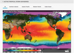
Below is a picture of the active tropical storm advisories for Sunday, November 20th. We are able to see one low pressure area around South America.

Screen Shot 2016-11-20 at 2.06.58 PM

Personal Water Footprint Calculator: The Results May Surprise You

Have you ever wondered how much water you use? Even though the average American uses 100 gallons a day, the actual amount you use may vary greatly. National Geographic has created this interactive (and in my opinion, pretty entertaining) water footprint calculator. It can be found at:

http://environment.nationalgeographic.com/environment/freshwater/change-the-course/water-footprint-calculator/

This is a very thorough questionnaire. It start off by asking where your zip code, household size, year of your house, and what water using amenities you have in it such as sinks, toilets, showers. It even asks if any of them have been replaced recently to use less water. It then asks you about your usage habits of these and any other things you may have that use water such as a dishwasher.

It doesn’t just stop there. It asks you about your eating habits because it takes a lot of water to feed America whether it is to water livestock or plants. It then follows that with your energy usage, and finally, the things you buy (especially clothing and paper products). You’re able to see how your water consumption changes as you answer each question and you can see the average American usage statistic for each question.

At the end, it’ll tell you your usage summary. For me, I use less water, on average, in my home in Charlottesville, my food consumption, and the things I buy. However, I can reduce transportation and energy usage. I urge all of you to try this: it takes 5 minutes and you may be shocked at how much water you’re actually using.

This directly relates to the hydrosphere and human water consumption. Because we only have 0.3% of freshwater available to us, we need to be smart about our usage. Additionally, our water resources vary based on the area we live in so there may be an abundance or shortage if people are using water without having an idea of how much.