Bill Nye the Science Guy on Climate Change

by Amanda Doyle

He taught us the physics behind flight, mechanisms in an eyeball, and layers of the atmosphere (all accompanied by pop music parodies), but now, Bill Nye the Science Guy tackles a much more difficult issue… climate change.  An advocate himself, Bill makes frequent appearances at universities and conventions, and on news broadcasts addressing this modern concern.  In February 2010, soon after a blizzard crippled Washington D.C.,  Bill spoke on MSNBC as a guest of Rachel Maddow.  Many disbelieving politicians utilized the blizzard to debunk the theory of global warming; however, Bill explained that climate change may have been the driving force that created the catastrophic storm.  Accustomed to educating an elementary audience Bill provided a clear and concise explanation of climate change, one both students and elders alike could understand and appreciate.


Bill Nye Science Guy on Rachel Maddow Talking About Climate Change
msnbc, “Bill Nye Science Guy on Rachel Maddow Talking About Climate Change,” Youtube video, http://www.youtube.com/watch?v=sm05Mcah0i8 (accessed October 1,2011).

First, Bill clarifies that global warming was the initial term to address this phenomenon but since global warming created numerous misconceptions the current accepted expression is climate change.  He continues to explain that more energy is being trapped within Earth’s atmosphere and all of this energy is “stirring things up.”  Consequently, the world is warming leading to more intense phenomena, such as El Niño, which has a profound effect on weather in North America.  When Sea Surface Temperatures (SSTs) increase during El Niño more energy is released into the atmosphere making conditions more turbulent and resulting in extreme weather that can range from extreme drought, excessive rain, and even atypical snowstorms.

Lastly, Bill states that disbelievers of climate change are “unpatriotic,” and he reminds us that the Intergovernmental Panel on Climate Change received a Nobel Prize for their extensive research that brought to light this phenomenon, which will remain a heated topic of debate for years to come.

THE ART OF GLOBAL WARMING coal + ice photography exhibition open at three shadows

by Avery Shackelford
Nadav Kander, Chongqing IV (Sunday Picnic)
 Series: Yangtze, The Long River,
 Chromogenic Colour Print

 2006
 Chongqing, China picture taken from: http://sites.asiasociety.org/coalandice/photographers/ , picture credit information taken from: http://www.prixpictet.com/2009/view/605/5211

An art exhibition open Sept. 24 – Nov. 28 at the renowned Three Shadows Photography Art Centre in Beijing features the works of 30 photographers hailing from across the globe including the United States, the United Kingdom, China, Norway, Russia, Italy, Canada, Malaysia and Germany.

These artists’ photographs tell a story from the base of the coalmine to the peaks of the Himalayas.

Photographs, including those taken by American photographer and filmmaker David Breashears, who co-directed the first IMAX film shot on Mount Everest, demonstrate how the use of coal emits greenhouse gases that are warming high-altitude climates like the Himalayas, where rapidly melting glaciers are affecting river currents, which in turn play havoc with the lives of downstream residents.

The photographs span an “arc” of phases showing how greenhouse gases resulting from coal use go up into the atmosphere causing the glaciers to melt, thus affecting the hydrologic cycle. The exhibition also includes time-lapse photos that show the changing landscape.

The goal of the exhibition is to promote environmental awareness as well as tell a beautiful, yet haunting visual story.

For more information, and to watch a behind the scenes video with commentary from the curators see the gallery’s Web site: http://sites.asiasociety.org/coalandice/


Hurricane Tracker

http://www.surfline.com/hurricanetrak/

Hurricanetrak is a great tool that can be found on surfline.com. It allows anyone to follow or track the path of a tropical system or hurricane anywhere in the world. You also can keep an eye on weather conditions. The primary objective of this tool is to help surfers know where the best surf is. By using other tools, such as LOLA and Google maps, you can zoom in and out of storms, display various layers of forecast data, and also use interactive shadows and rulers to see exactly where a storm is going. LOLA is a global surf forecast. During hurricane season you can click on  individual storm names to see the current storms path. You can also access historical data to research previous storm activity. Specific details, such as wind speed, pressure, wind and swell direction, and wave height can be examined as well.

WATERLIFE: Promoting Awareness of the Great Lakes

WATERLIFE is a highly interactive website that focuses on a documentary that tells the “story of the last great supply of fresh drinking water on Earth,” which happens to be the Great Lakes.  Upon entering the site, you can choose from a number of images that transport the viewer to subjects related to the Great Lakes, such as invasive species, bottled water, power, recreation and healing.  It is possible to click on any of the subject, which then takes the viewer to a page that explains that subject more in depth and involves imagery from the film.  WATERLIFE essentially is promoting the conservation of the Great Lakes due to its importance locally, regionally, and internationally.  It relays facts like only half of the Great Lakes wetlands remain intact.  Also, 100 billion gallons of water evaporate from the lakes each day.  The Great Lakes have been greatly impacted by invasive species, which harms not only the ecosystems but also the local economies.  These species include Asian Carp, Zebra Mussels, and the Lamprey.  A great aspect of the website is that although it speaks of many issues and negative impacts associated with the Great Lakes, it also focuses on positive action that can be taken.  Education is a major component of this positive action.  WATERLIFE is a part of that education tool, as it uses storytelling and beautiful imagery in order to promote awareness and the conservation of the vast supply of fresh drinking water in North America.

National Parks Infinite Photo

Follow this link to see some of the most stunning images of national parks. Keep zooming in to see amazing geographic features, bizarre animals, and fascinating rock formations. The fun goes on for hundreds of pictures. The pictures were submitted by normal people who shared their photography with national geographic. I have literally been playing with this for the last two hours.

http://travel.nationalgeographic.com/travel/national-parks/infinite-photo/

Just an example of one of the amazing images from this website.

Monster in Lake Baikal

As we have learned in class, Lake Baikal is the largest lake in the world; it is home to many species of plants and animals. This site explains why it is no surprise that a possible lake monster resides somewhere in the depths of this enormous freshwater lake. There have been many eyewitnesses to what is described as a “sturgeon-like monstrosity” with a cross between a seal-like mammal. Some theories of origin include the land locking of the beast within the lake as a result of the last ice age, possibility of a sea-serpent swimming up one of the many rivers or streams that feed into Lake Baikal, or the most popular of all theories, a remarkable mutation caused by the pollutants released into the Lake. The Baikalsk Pulp & Paper Mill is the largest contributor of pollution into the lake, this company “has dumped approximately 210,000 cubic meters of untreated waste into Lake Baikal every day since 1966.” Though scientists have not been able to apprehend and study this unknown monster, the possibility of its existence is highly likely since the bottom of Lake Baikal has not been explored to this day, which may contain many undiscovered species.

http://americanmonsters.com/site/2010/01/baikal-lake-monster-russia/

The Freshwater Initiative

The Colorado River Years Ago

This  National Geographic site focuses on fresh water initiatives in hopes of preserving what’s left of the Earth’s freshwater. As we know, we roughly have about 0.3% of usable freshwater. Today, humans use water from the ground, rivers, and other freshwater streams to supply water to cities, farms, and factories. Rivers and other fresh bodies of water carve shipping routes around the globe, and supply us with food and recreation. However, these rivers and lakes are slowly becoming scarce. National Geographic focuses on the Colorado River which was once winding 1,470 miles (2.366 kilometers) from the Rocky Mountains to the Gulf of California’s Sea of Cortez back when it was plentiful. Nowadays, the water level barely reaches the full circle.

The biggest problem these fresh bodies of water face is the manipulation WE do to them. For instance, chemical fertilizers and animal waste sprouting from agricultural lands and residential areas which are swept into local streams, rivers, and other bodies of water. This type of surface runoff eventually lead to what we drink today and even the ocean. The result: polluted drinking water sources and the decline of aquatic species, in addition to coastal dead zones caused by these contaminants. Not to mention, the other dam initiatives which end up displacing thousands of people worldwide in hopes of obtaining and “keeping” more water.

Through this website, National Geographic suggests a way for us to reduce our water footprint with a pledge. So far, there have been 7,624 pledges and a total of 1,398,030 gallons of water pledged through this initiative.

Feel free to take the water footprint test to see if you are using more than the average person in the United States. We might believe that we use the most amount of water through flushing, but nearly 95 percent of our water footprint is hidden in the food we eat, energy we use, products we buy, and services we rely on (such as transportation). As a college student at UR, I am currently using 5% of your water footprint alone through everyday processes such as showers, laundry, etc. The average American relies on nearly 670 gallons of water a day just for electricity production in order to produce food. Why not take a look at how your local conservation efforts connects to the preservation of rivers and wetlands globally. Small changes can lead to big and effective changes for the future.

Click here for the TEST and see how much water you can save by changing your way of life:

http://environment.nationalgeographic.com/environment/freshwater/water-footprint-calculator/

Chesapeake Bay Foundation

The Chesapeake Bay Foundation is an organization to save one of our most prized natural treasures on the east coast — The Chesapeake Bay.  The organization advocates for the cleanup and protection of the Bay.  As stated in their mission “The Chesapeake Bay Foundation’s (CBF) mission is to save the bay and keep it saved.”

Formed in 1957, The CBF has been recognizing the poor treatment of the bay and has been pushing for better treatment and care of the waters and the animal life in it.  They fight for bold and creative solutions to pollution across six states, the Chesapeake Bay Watershed, and speak to business, the government, as well as the public.  The CBF uses legal means when necessary to enforce already set laws and promotes education of environmental protection to those that wonder and have interest.

Growing up on the Bay I know how important it is to save the bay.  It is a beautiful area with an abundance of wildlife that feed off the rivers and environment both in the the Bay and the Watershed itself.  Conservation of the Bay is essential is keeping a thriving environment.  What have you done to help stop pollution of the Bay?

Save the Bay!

Census of Marine Life

 Free Stock Photo of Ocean Birds This is the official website of the Census of Marine Life, an international scientific initiative that is seeking to catalog marine biodiversity and explain the various distribution patterns of marine life.  There is a map that shows all the different sites that are being researched, along with color codes that show the boundaries of the site regions.  Clicking on the acronyms next to the color swatches on the left side of the map, will give a brief description of the work being done there, as well as a link to the individual site’s webpage. The main COML site has a photo gallery of some pretty crazy looking marine species, as well as a description of the research they have done.  The full report of the census will be released this October, so there is definitely going to be some cool things coming out of the organization leading up to this release.  People should definitely give this a look, if only to check out the pictures.

Tsunami’s

Fake Tsunami in Honalulu
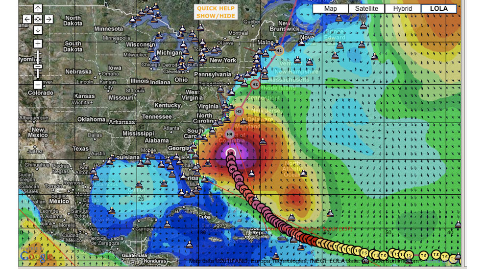
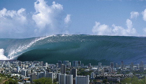
A tsunami is a series of ocean waves generated by sudden displacements in the sea floor, landslides, or volcanic activity. In the deep ocean, the tsunami wave may only be a few inches high. The tsunami wave may come gently ashore or may increase in height to become a fast moving wall of turbulent water several meters high. The National Oceanic and Atmospheric Administration (NOAA) has the primary responsibility of providing warnings but also carries out research and observations as well. On their website they educate on why tsunami’s occur, how to prevent them, what to do when one happens, information on past global tsunami’s, as well as photos and interactive demonstrations of the oceanic beasts. Check it out!