Oxbow Lakes

The website ThoughtCo. offers various articles on multiple subjects, including physical geography, political geography, urban geography, climate, etc.  Their goal is to provide resources for students and teachers of geography through articles, images, maps, etc. that explore these various topics within geography.  One article within the category of physical geography explains oxbow lakes.

https://www.thoughtco.com/physical-geography-4133032

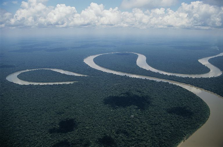
Oxbow Lake beside the Amazon River

Water in rivers flows faster on the outside of its curve than it does on the inside.  This creates erosion and decay that does not happen on the inside, creating the final curved shape.  The neck of the loop eventually erodes to the point of cutting itself off from the main river, creating the separate body of water known as the oxbow lake.  Oxbow lakes can also be initiated by humans in order to meet navigational needs.

Oxbow lakes are bodies of water that are cut off from the river in which it began.  They are unconnected but still close by since they were originally part of the river.  Oxbows get their name from the bow-like appearance of them, due to the nature of rivers’ curvature.  The water in these lakes no longer flows, but relies on precipitation, sometimes just becoming swamps.  Due to lack of outside water, these oxbow lakes often evaporate entirely within a few years of breaking off from the river.  As climate change continues to rise, these lakes will evaporate at faster rates.  This reinforces the rising issue of water scarcity and the impact that humans have on it.  In the United States, Oxbow lakes can be found along the Mississippi River and in Crater Lake, Iowa.

EPA & Urban Heat Islands

Heat islands are crucial to understand whether one is laying out the blueprint for a city, or just planning out their own home.  The EPA has dedicated a section of their website to teach the public about such heat islands.  The website is divided into two parts, the first is about understanding heat islands and the effects, and the second part is about reducing the effects of heat islands.

On the first part of the website, the EPA discusses how the dark and impervious surfaces (occurring mainly in cities and some suburban areas) reach higher surface temperatures than what the actual air temperature is.  Due to the increase in surface temperature, not only does the air temperature now slowly increase, but there is also an increase in the demand for electricity.  Since the demand for electricity goes up, the production of electricity must also go up; this in turn releases more pollutants into the atmosphere.  Heat islands and higher temperatures have also been linked to an increase in the number of hospital visits in both the young children, the elderly, and the homeless.

The second part of the website aims to inform readers about ways to reduce the effects of heat islands – such methods include planting more vegetation, both on top of and around buildings, and also using materials for pavements and roofs that reflect more energy than they absorb.  These methods to reduce the effects of heat islands are recommended on both the household level, and community level.  Further, cities and towns can change codes so that buildings comply with policies that make heat islands less prevalent.

As the younger generation seems to be the one more involved with climate change and the environment, I found it a little surprising that the EPA did not recommend any solutions for students or non-homeowners.  Just about all the suggestions to reduce the effects of heat islands were only applicable if one is a homeowner in a suburban area.  It would be beneficial for the EPA to market their solutions towards those who are most interested, yet at the same time, marketing effective solutions towards the younger generations is quite difficult given the circumstances of the problem.