
 The United States Geological Survey (USGS) is an agency of the government that studies the landscape, natural resources, and natural hazards of the US. These categories include information about the water, energy, minerals and natural resources in the US, as well as the health of our environment and the impacts of climate change and land-use change.
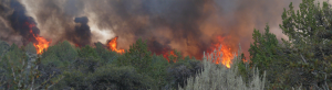
With the recent wildfires in California, the USGS is more important than ever. Its technology helps produce science, data, and tools that are critical in making decisions before, after, and during wildfires. On their Wildland Fire Science webpage, the USGS goes into the specifics of their fire research, data, and tools.
In the Fire Science section of this website, the USGS goes into greater detail about large fire forecasts, fuel mapping, and burn mapping. In the large fire forecasting portion, there is a map that uses satellite imagery to show daily fire potential predictions. In the fuel mapping portion, there is a map with over 20 geospatial layers that describes vegetation, disturbance, fuel, and fire arrangements for the United States. Finally, the burn mapping portion describes projects designed for mapping the perimeters and severity of wildfires in the US. Overall, the USGS provides advanced and useful tools for the government and individuals to look at in-depth data about forest fires.
https://www2.usgs.gov/ecosystems/environments/fireecology.html