Tag Archives: United States

Cartographic Irony: When Protesting Oppression Oppresses

This gallery contains 4 photos.

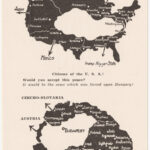
Protest maps allow marginalized groups to harness the “mythical power” of maps to challenge the status quo. But even protest maps can use harmful stereotypes and gross distortions to make their arguments about social change.   This map is important because … Continue reading

More Galleries | 2 Comments

The Corporate States of America

According to the map’s creator, Steve Lovelace, brand loyalty may soon take on a whole new meaning. Lovelace’s map, titled The Corporate States of America, is a visual representation of his theory that the modern nation state will soon no … Continue reading

Posted in Maps of the Week | Tagged , , | Comments Off on The Corporate States of America

Map of the Week 5 (October 7 – October 13): Territorial Growth of the United States

Source: http://maps.nationalgeographic.com/maps/print-collection/us-territorial-growth-map.html When the United States declared its independence from Great Britain in 1776, the country only consisted of thirteen colonies. In the matter of three centuries, the borders of the country expanded and transformed to create the fifty states … Continue reading

Posted in Maps of the Week | Tagged , , , , , | 1 Comment

Map of the Week 4 (September 30-Ocotber 6): The Racial Dot Map

Source: http://demographics.coopercenter.org/DotMap/index.htmlSource: The United States of America has had a tumultuous past regarding race relations, as you may have learned a thing or two about in history class. Borders of states were often shaped with race and culture in mind, namely … Continue reading

Posted in Maps of the Week | Tagged , , , , , , | Comments Off on Map of the Week 4 (September 30-Ocotber 6): The Racial Dot Map