
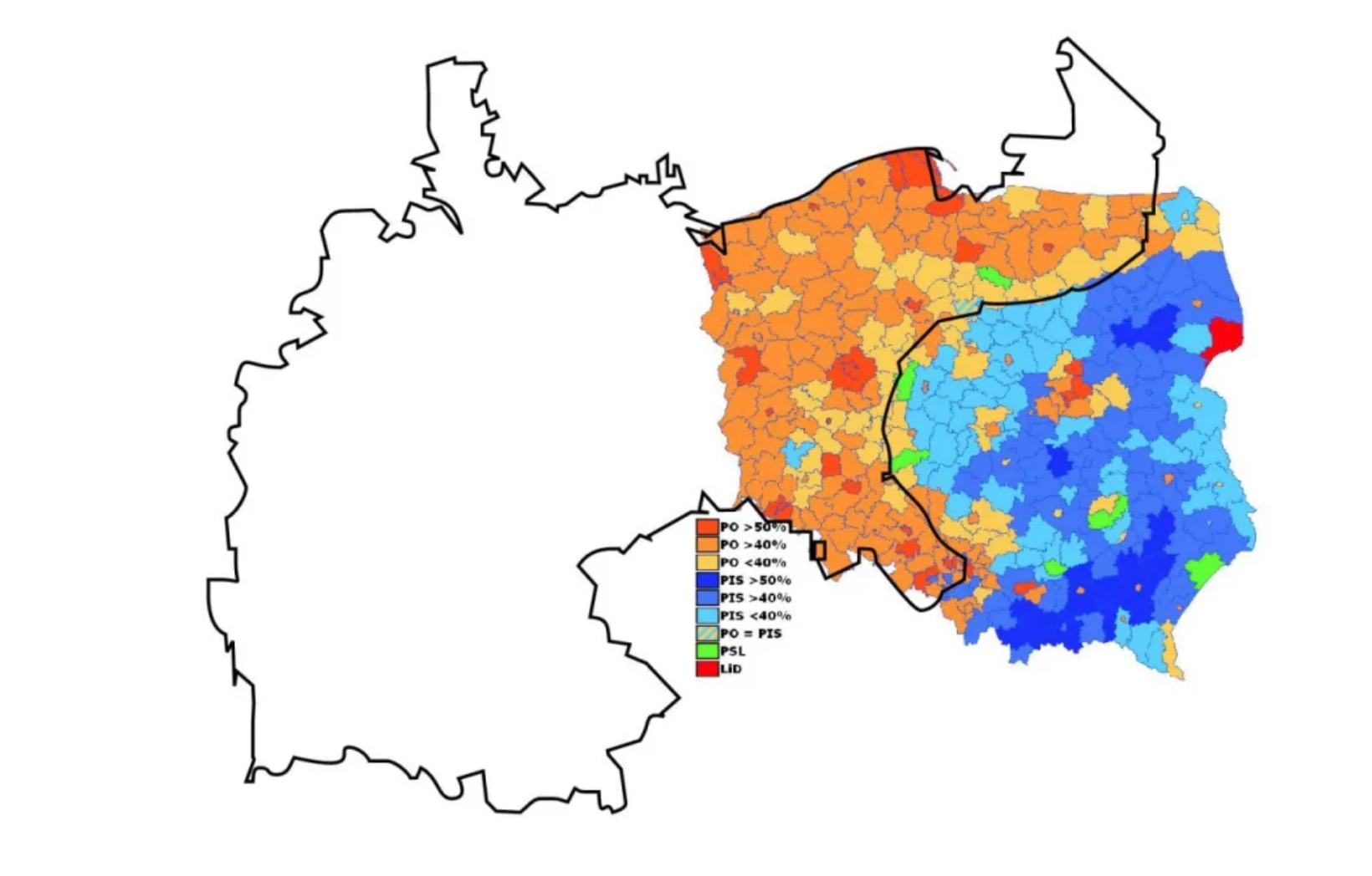
This map shows the boundaries of the German Republic before the 1st World War overlayed with the current boundaries of Poland and the 2015 Polish Parliamentary elections. This map portrays the clear divide between Eastern and Western Poland. The Eastern side has been heavily influenced by the politics and social conservative traditions of the former Soviet Union. Meanwhile, the Western Provinces of Poland, influenced by Germany, have more progressive voting tendencies. This election between the PiS (the more Eurosceptic party) and the PO (pro-greater economic ties to the EU) highlights the remnants of these former borders. From a cartographer’s perspective, this map is successful at encapsulating the persisting nature with which historical boundaries have permeated into contemporary political dynamics.
The Western Provinces of Poland are those contained within the boundaries of the former German Empire and are more economically developed than those in the East. Although the population of Western Poland has drastically changed over the past century, with the displacement of Ethnic German populations following World War One, the region still has the closest cultural and economic ties to Western European nations. Outside of Warsaw–the provinces of Lower Silesia, Greater Poland, and Silisia have the highest GDP per capita of the provinces in Warsaw. All three of the aforementioned provinces are heavily reliant on trade with the EU and tourism from neighboring European countries. The tourism industry of Lower Silesia in particular is composed of visits offered to the numerous medieval castles dating back to the German Holy Roman Empire and Habsburg Empire. The region is also a manufacturing hub–with coal mines, timber harvestation sites, and factories dotting the landscape. In 1988 the area underwent major environmental reform after major smog and deforestation affected the region. The regions within Western Poland also produce the most agricultural commodities with poultry, apples, rye, and potatoes being major staples of its export economy. For these reasons, it is unsurprising that the populace supports the PO party in Polish elections due to the party platform championing closer economic relations with the EU.
In contrast to the regions of Western Poland, the culture of Eastern Poland is dominated by its proximity to the former Soviet Union. Devotion to Christianity is especially stark within these provinces and the Subcarpathian region in the South West portion of the nation containing the highest percentage of Christians within Poland (90%). This region is also less economically developed with the five poorest provinces, calculated by GDP per capita, all being confined to Western Poland. The least economically developed province, Lublin, has a GDP per capita of 10,700 USD per capita compared to the national average of 18,321 USD. The region is dominated by agricultural trade with the neighboring countries Ukraine and Belarus. During the ongoing Ukraine-Russia conflict, the province of Lublin has accommodated 300,000 Ukrainian refugees, the most of any region. For these reasons, Eastern Poland maintains less stringent ties to the European Union and votes for the euroskeptic PiS party by large margins.
Although the contemporary political distinctions of East and West Poland appear to be straightforward, the map illustrates the susceptibility for metropolitan regions of Eastern Poland to be more favorable to the PO than the PiS. This trend is reflected in the three largest Polish cities, all located beyond the boundaries of the former German Empire. These cities–Warsaw, Krakow, and Lodz–are reliant on the burgeoning technological sphere and are cosmopolitan in nature. For these reasons, they broke with their regional trends and voted in wide margins against the PiS. Although the PiS has maintained control of the Polish government in the most recent elections, some analysts have acknowledged that the growing technological sector within smaller Polish cities may bring Poland closer to the EU sphere of influence. Others however, acknowledge that the recent uptake in immigration to EU nations may keep conservative Polish citizens from breaking away from voting for the PiS.
Stepping away from an analysis of trends within this map, the overarching concept of utilyzing trans-national historical borders overlaid upon contemporary phenomenons is a way to portray evolution or lack thereof over time. Maps displaying trends from the Austro-Hungarian empire overlaid upon recent elections in Romania have utilized such a tool to display such occurrences. Overall, this tool could be used to both stir nationalist sentiment reminiscent of past governance and portray shifting demands of given populaces. In the near future, I envision such maps to become commonplace within mainstream political thought as both globalist and nationalist parties continue polarize nations across the globe.
I really like this concept you talked about at the end of your piece about overlaying historic borders on contemporary ones to portray evolution. You explain it to great effect and it really is an effective tool to spot trends and explain phenomena. This is a pretty acute example of this method, and I’ve also seen it used to explain voting trends in America, for example, when maps of former enslaved persons are overlaid upon voting maps. I also appreciate the analysis done on this map in particular. There are lots of things to cover with just this map, and you have effectively demonstrated them all. Religion, politics, wealth, and economy have all been very well analyzed in the context of the map, and the analysis is very well done.
Nice Job Thomas! This breakdown of a map comparing the pre-World War I German Empire’s borders with present-day Poland and the 2015 Polish Parliamentary elections is pretty intriguing. The post delves into the East-West divide in Poland, tracing it back to historical influences and economic disparities. The breakdown of GDP per capita and specific economic activities in Western and Eastern Poland adds a layer of detail, linking economic factors to regional voting patterns. It’s interesting to see how metropolitan regions in Eastern Poland, like Warsaw and Krakow, defy regional voting trends due to technological advancements. The concept of overlaying historical borders on contemporary phenomena, as seen in voting maps in America, is a cool insight into understanding societal trends. Overall, it’s a well-rounded and informative piece that strikes a good balance between detail and readability. Good job!
Nice Post Thomas! It’s cool to see how this history connects to the different political views in Poland now, like how the west tends to be more modern and connected to the EU, while the east is more connected to the Soviet Union’s history. I also like how you broke down the geographical differences between places. For example, how Western Poland, influenced by Germany, is richer and more tied to the EU, while Eastern Poland, closer to the Soviet Union, is less wealthy and more supportive of a party that’s skeptical about the EU. The cities, though, show a different trend, with big ones like Warsaw and Krakow leaning toward the EU. Overall, I think you did a great job connecting history and politics using maps.