
The map above is the second map in series.
A Cold War is a state of conflict between nations that does not involve direct military action but is pursued primarily through economic and political actions, propaganda, acts of espionage, or proxy wars waged by surrogates. In International relations literature, it is the period between shortly before the end of World War 2 till the breakup of the Soviet Union in 1990 which is known as the Cold War. During this period, the old rivalry between the West, led by the USA, and the Soviet block, led by the USSR resurfaced souring the relations. The main causes of the Cold war would be Struggle for Hegemony/Resources and Clash of Ideologies. As we all know, the Cold War era saw an influx cartographic propaganda, particularly between the US. and the Soviet Union. Such influx appeared in many aspects during the Cold War for the two countries to compete for their political sphere of influence and economics benefit. The three Henry Cabot Lodge’s Maps would be representatives of such cartographic propaganda era.
RB-47 Incident and Henry Cabot Lodge’s Response:
In July of 1960 a U.S. plane was on an electromagnetic observation flight over
international waters bordering USSR territory when it was shot down by the Soviets. The Soviets claimed that the plane was in their territory so they had reason to shoot it down (during Cold War) but the U.S. navigational system said otherwise. In Henry Cabot Lodge’s speech he uses these maps to defend the U.S. against Soviets’ accusations by proving they had lied and were in the wrong. Lodge uses his maps to make comparisons between the U.S. and the Soviets and in his speech he says, “The difference between the United States and the Soviet Union is that we shoot their planes with cameras. They shoot ours with guns and rockets…”
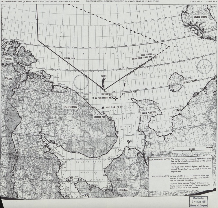
In the first map, the solid black line represents the planned route for the
American aircraft’s flight which shows that the planes were to fly over
international waters at all times (Never come within 50 miles of Soviet territory)
They took off from England and flew into the Baren Sea. This would’ve been the flight path if Soviet fighter jet didn’t force RB-47 off course. In the second map, the dotted line represents actual flight path of the plane. The large arrow labeled “Fighter” shows location of the Russian fighter jet. This fighter jet attempted to push the American Aircraft into Soviet Territory. The star labeled “Soviet Claim” is where the Soviets claimed RB-47 entered their territorial waters. However, the “Closest Point” dot on the map, determined by U.S. navigation systems, shows RB-47 still significantly outside of Soviet territory.
“1522Z Position” labeled by the cross/X ,where the solid line stops, is where RB-47 was shot down. The third map shows 6 Soviet flights getting dangerously close to U.S. territory for electronic reconnaissance. It is a great representation of how close the U.S. is to Russia. The dates ranged from March 1959 to February 1960, all before the RB-47 incident. In his speech, Lodge claims there are many more flights just like these that would help prove his point. The map also emphasizes how they were within 12 nm and we didn’t even get within 50 nm.
The three maps accurately shows maps from the US’s side of the Cold War. Maps prove that the USSR was lying about where they shot down the plane. With the maps being black and white large bolded symbols are used to
highlight important elements, such as large arrows, stars, and bolded lines.
Map #3 uses the small amount of space between Russia and Alaska to
reveal how close we really are and this could’ve been a fear factor during
the Cold War. It is easy to understand with a minimal amount of background info because of the simplicity of the maps.
These maps explains how the Soviets lied, why the Soviets should have committed a crime in connection with the missing plane event, and comparison of the flights actions with the fact of Soviets flights across the boundary. Such statements and demonstrations helped the United States to fight for more say and international attention in this event to gain international support and political benefits with a relatively just identity —asked the council to investigate the crime of the Soviet Union and demanded the release of the trapped people.
By showing the aircraft’s prescribed routine and other routes as well as the location information of each event points on the map, the map here realizes circulating through multiple contexts + cultures, driving theme on the map according to the term of “rhetorical life” of the map. The map is to help realize the transfer of ideas in the specific situation.