Team Map Presentation: Post-War New World Map

Maurice Gomberg is the author of this interesting map.  We don’t know a lot about Gomberg besides that he was teacher from Philadelphia and that he self published this map.  Gombergs ideas are radical and interesting. He is a pacifist and wants wars to end as he calls for the disarming of militaries. He believes that the United States has the responsibility to lead the world after the war is over. He says that United States is in better economic state and has the best geographic location to run the world. He wants to establish a world court and world league of nationalities to run the relinquished countries and to help re-establish society in Europe. He also wants to ban all Germans and Japenese from the Western Hemisphere.  A final interesting note is Gomberg’s idea to rename and consolidate countries like renaming South America and its counties to the United States of South America.
As Gomberg describes it, this map is an “Outline of Post-War New World Map as the U.S.A., with the cooperation of the Democracies of Latin America, the British Commonwealth of Nations and the Union of Soviet Socialist Republics, assumes world leadership for the establishment of a New World Moral Order for permanent peace, freedom, justice, security and world reconstruction.”   He created this post World War II prediction before the allied victory as a very optimistic forecast of the post-war “New World” that he envisioned, with regions (instead of countries) divided between British, Soviet, and U.S. control.   His ideas were very controversial because he eliminated the idea of countries, put all the world control in the hands of few, and made the north more powerful with his pro-US and allies viewpoint, especially through his use of the Mercator projection.   One particularly interesting feature of Gomberg’s map is his legend.   The map is colored in regions, the 3 primary colors being blue for the U.S.A. and Protectorates, red for the British Commonwealth of Nations, and pink for the U.S.S.R.   However, there are smaller regions on the map in various colors, such as green, yellow, orange, and purple, which he chose not to include in the legend, therefore indicating the author doesn’t view them as important and wants to draw attention away from them.
Posted in Uncategorized | Comments Off on Team Map Presentation: Post-War New World Map

World Oil Trade


This map, though simple, establishes a sense of internationalism and power through its visual rhetoric incorporated in intentional choices and silences about its perspective on world oil consumption. At first it appears a very basic map: it’s a rather traditional, all-encompassing view of the world with brightly colored countries set against a basic backdrop. Yet with further analysis, the map contains a number of decisions which set it apart from other similar maps. Through bright colors and linked trade routes, the oil map creates a global perspective backed by the biased influence of its creator, the oil company BP.

Though the countries’ design isn’t complex, the map’s top layer contains a series of interconnected lines which are somewhat puzzling at first glance. In fact they’re symbolizing the world oil trade in 2011, with the numbers given in millions of tons. Pieced together in a spider-web of lines, they appear to show common trade routes between the chosen countries. Although the continents are color coded, the colors seem somewhat sporadic and not very symbolically important. No land masses are directly labelled; instead a legend appears at the bottom left corner which strangely chooses to label only three countries: The US, Canada, and Mexico, while the rest encompass far larger regions. Without any explanation, the US appears in a unique color, a light green, while Australia and South Asia share a bright orange. Therefore an important question arises: why solely these three countries? Like any map, these choices aren’t made without motive, as mapmakers and those who sponsor them must make biased decisions. In this case especially, the business intended to showcase their own product as a crucial, globally connected good. BP chose to include the countries it found financially important while ignoring those of lesser monetary importance. Because they focus on North America in their labeling, this continent must be of importance and the map’s other details encourage this view.
Through including visually undivided countries while uniting the world with systematic trade routes, BP creates an integrated, easily conquered earth. Here the world isn’t cut in half by the Atlantic, but is easily connected through a number of routes. Product easily flows from one point across international borders to its final destination. These orderly channels create a structured network, creating a parallel between the actual process of oil trade and the map. They box in parts of the world while attaching countries to one another in a uniform, neat system. The regions proclaimed most important by the number of lines are the United States, Middle East and what the map deems “Asia Pacific”. This sense of internationalism is constructed through the flowing lines as well as the silence of boundaries. They connect certain regions in uninterrupted movement, while other parts of the map are completely devoid of any lines. The map, and therefore its creator BP chose to surround the most important sectors which its business manages. Cartographically the map ignores a number of common conventions while choosing to highlight the creator’s intentions of globalization. This map doesn’t exist solely to further knowledge about politics or even geography. Instead it ignores these traditional themes to focus on visualizing data of one particular commodity, while seeing the geography through this company’s corporate lens. Oil is an extremely lucrative world resource that consists of an extensive trade industry as indicated by the map.
Reflecting its creator, the map focuses on the nations where BP has its largest shares— hardly a coincidence. The map is largely interested in oil and ignores other features prominent on most maps, including any presence of water or indication of topography. By focusing on such a narrow theme, it creates the sense that this is the world’s most important product. Mapmakers define maps through their personal interests, where in this case they are asserting their world power and creating the idea that the world in dependent upon this one product. According to the map, millions upon millions of oil flow from nation to nation yearly. A title declares the routes shown to be only “major trade movements”, hinting there are even more existing trade routes than the ones depicted. By only including the routes deemed most important, it ignores smaller countries and those less financially dependent upon the product.
Even simple maps are layered with countless implications. In this case, BP wishes to appear as dominant and organized as it manages its single good throughout the world. With further knowledge of map rhetoric, a reader can more fully comprehend the nuances all maps include. Here a seemingly basic map becomes an object to further an idea of an interconnected, powerful world which is ruled by oil.

larger image here: http://www.businessinsider.com/maps-that-explain-the-world-2013-2?op=1

Works Cited
“BP.” In America. N.p., n.d. Web. 14 Oct. 2014. .
Wile, Rob. “36 Maps That Explain The Entire World.” Business Insider. N.p., 04 Feb. 2013. Web. 8 Oct. 2014.

Posted in Uncategorized | 3 Comments

Atlas of the Week: An Artistic View

http://atlas.esri.com/?p=home

This online compilation of atlases allows users to both search through a database of pre-created maps and to create new maps. It is very similar to CartoDB in its creation capabilities, yet offers some unique visual approaches. The “Featured Atlases” located at the bottom of the page are unique and visually appealing approaches to mapping just about every topic. The maps are also capable of layering dozens of issues together which are quickly sorted through in accessible, power-point like slides. I found it interesting to explore these projects and look at the topics they found most important as a part of their own maps.

Posted in Uncategorized | Comments Off on Atlas of the Week: An Artistic View

Europe: The Original Explorers

This map details the journeys taken by European explorers in the 1400-1500s

America is often recognized as being one of the greatest nations on earth. Truth is, this map of the week would argue, that America owes it to Europe, and especially the explorers in the 1400-1500s, for figuring out that their land even existed! This map entitled “European Exploration” coherently displays the routes taken by all the notable European explorers, many of which made maps of the world based on their journeys (off of which we’ve based most of our modern maps). This new land was stumbled upon and was, at first, thought to be the Eastern coast of Asia. Further exploration by Spain, Portugal, France and England made this map, along with every other modern representation of the world, possible. Through the historical context, intended audience, and cultural implications, this map provides an understanding of Europe as the leading nation in exploration due to the apparent time period, lack of professionalism, silences, and the concept of a shrinking world.

This map is clearly from a European perspective; the continent (namely, Western Europe) is dead center and all routes lead out form there. The emphasis of this map is primarily focused on the four countries taking part in the exploration, including the explorers of those countries. Notice the lack of detail on every other landmass that is not Europe. Furthermore, the little information this map provides about the other landmasses is clearly dated. The entire landmass known today as “Asia” is labeled on the left as “Russian Empire” and on the right as “Siberia.” The perspective here is far from modern-day. Although the rest of the land is hardly the focus of this map, it helps to establish the historical context.

The audience is likely intended to be European, as Europe is in the center and doing all the work; however, a more fitting audience appears to be just about anyone. Sure, this map wants to show Europe as the founders of the world. As bold as that may sound, this map gives Europe that identity as the nation that founded, explored, and documented all of these massive and unknown places. It could certainly function as a “weapon of imperialism,” as Harley would put it. The map empowers Europe as an empire; they explored, they documented history, and they possess that knowledge that no one else does. That being said, this map is not intended for the scholarly elite. The color-coding suggests a possible younger/less-educated audience. Anyone could read this map, but it would not benefit someone that was an expert in the field of European history. By the way, did you notice that “European” is misspelled in the title? There is an obvious lack of professionalism in this map, which suggests that it was intended for anyone that just wanted to get a basic visual understanding of European exploration.

The silences in this map really say something about the cultural context. The major “silence” in this map is the staggering lack of detail on any of the land that is not European. Granted, this information is unimportant for this map. This map reveals the exploration of unknown lands and conceals the details of those lands. The map is more about the journey itself and less about the actual destination. The explorers only knew of (present-day) Africa, America and Asia as giant landmasses; consequently, this map portrays them as such. There are practically no names or colors in the map except for Europe, because everything else was a mystery. The focus is on the coasts, not the inlands. European explorers concerned themselves with the size and shape of the world, not (yet) with what these new lands held on the inside. The information shown in this map also gives the perspective of a “shrinking world.” Europe never knew what lay beyond the horizon of the Atlantic Ocean; that is, until Magellan circumnavigated the globe (first voyage to ever accomplish this). This voyage gave the Europeans an idea of just how big our world is. Having conquered the horizons, the limits of the seas became more familiar and their world just got a lot smaller.

Historical context, apparent audience, and cultural implications of this map reveal a great deal about its message and its purpose. Each of these aspects contributes to the idea that this map portrays Europe as the nation of exploration; the ones who discovered the shape, size, and limits of the world; the nation that took the initiative to discover new and unknown places.

Posted in Maps of the Week | Comments Off on Europe: The Original Explorers

Atlas of the Week: Antiques


(pictured above: A Map of Virginia, North and South Carolina, Georgia, Maryland With Part of New Jersey &c.)


LINK

With everyone from Ptolemy to the 1890s, George Ritzlin Antique Maps & Prints has sold centuries-old atlases and prints for decades.  Not only does this online atlas connect you with multiple galleries full of cool old maps, but it also offers a place to learn more about cartographers and the history of mapmaking – not to mention a collection of scholarly references available to the public as a study resource.

I recommend visiting their “News” tab for a moment, which is updated sporadically with interesting or unusual maps.  Currently posted is a map of the Chicago Transit Authority elevated system tattooed on a woman’s foot.

“George Ritzlin Antique Maps & Prints.” George Ritzlin Antique Maps & Prints. Accessed October 2, 2014.

Posted in Atlases of the Week | 1 Comment

I’ll Have What He’s Having: GE Labeling Laws across the Globe

Unless he’s visiting the farm himself, the average American has no idea what GMOs, or genetically modified organisms are in his dinner.

However that’s not for lack of us condemning the practice. According to a 2013 New York Times poll, 93% of Americans want genetically engineered foods to be labeled, with about three-quarters concerned that GMOs could carry negative health side effects. Many feel it’s time for the United States to catch up with the sixty-plus other nations that have mandatory labeling on nearly all GE (genetically engineered) foods. The issue concerning GE food is transcribed in this map entitled “Genetically Engineered Food Labeling Laws.”

This world map, drawn simply with only the individual countries’ outline and title, is overwhelmingly political. It measures the strictness of GE food labeling regulations in shades of blue and green and represents the most stringent laws with a dark, forest green. The presence of green, traditionally a color of healing, gives the illusion that the dense, dark European epicenter is safest, most advanced. In contrast, the vast majority of North America isn’t highlighted at all, indicating the absence of government-enforced laws regarding food labeling. To further emphasize this point, the map includes a small pop-out – a close up of Europe – that brings to light which nations regulate and how very few do not. The mapmakers point out facts that would perhaps shock the US public to learn; even stereotypically disadvantaged, impoverished nations have GE food regulation, but we do not? Are big businesses and the government deliberately deceiving Americans by letting the food we eat go uninspected? The mapmakers here allude to the outdated system of First World vs. Third World. In the decades following the Second World War, countries included in NATO were classified as “First World,” those in the Communist Bloc were “Second World,” and all remaining unaffiliated nations were termed “Third World.” Much of the Global South, including Africa, was cataloged “Third World,” and the term consequently became synonymous with poverty, sickness, and civil unrest. As the majority of Africa and North America are uncolored in this map, it draws a connection between the former First and Third World countries. Given that these phrases have since been replaced in the post-Cold War era by the terms developed and developing, the mapmaker’s claim is deemphasized by using this obsolete method of comparison.

It’s also relevant to note that this map is produced by the Center for Food Safety, a national non-profit advocacy organization which asserts its mission as “working to protect human health and the environment by curbing the use of harmful food production technologies.” As a nongovernmental organization raising awareness on behalf of its personal goal, the Center for Food Safety uses the “neutrality” of the map to make a visual argument. The organization name draws the eye; it’s large and easy to read, with “FOOD SAFETY” bolded. The logo beside it is red, the only bright non-green, blue, or yellow color to appear on the map, a decision that argues its importance aesthetically. Both sit right in the center, between the legend and a close up of Europe. This institution is sending an obvious message out through this map: the labeling of GE foods should be government mandated and the US, as a developed nation, is behind in this regulatory business on the world scale. The cartographers are endorsing the belief, whether it is true or not, that public health is dependent on how sensitive we are of what we eat, and Americans are not at all attentive. As opposed to reading prose, where an author is clearly present, people often take maps as unrefuted fact since virtually only cartographers deal directly in their creation. Using a map as a public service announcement is in fact a mainly political tactic. Cartography as a medium of communication is extremely useful in creating the impression of total objectivity.

When discussing food production and distribution, it seems important to discuss the underlying origin of the issue as well. Who is growing this allegedly unsafe food? Who is buying it? How prominent are GMO seeds on a national scale as compared to non-GMO and heirloom varieties? Closely attached to the issue of consuming a product is the question of its origin, or, in the case of endangered public health, any harmful side effects. If this cartographer’s intention is to truly further our understanding of how health is affected by GMOs, the map could also list rates of sickness, perhaps, attributed to consumers ingesting them. Relatedly, such a minimalistic, broad map does little to highlight the economic situations of specific communities, or even general regions. The availability of non-GE foods can vary widely from place to place; high-priced non-GMOs could be unattainable to low-income citizens, which introduces a new disparity to the GMO vs. non-GMO food argument. This map does not illustrate any other related centent, leaving the viewer with partial, debatably unfounded information connecting public health and GE food. The map is arguably anti-genetic engineering propaganda, subconsciously connecting the idea of endangered wellbeing with harmless GMOs. The cartographers contend that we are blinded by our limited knowledge of GE food, and their map only confirms our blindness.

This map is a fairly recent publication, only published in 2013, and deals with a very current issue. Despite overwhelming evidence of Americans in favor of labeling laws, we have yet to embrace the system. Petitions and protests against GMOs is an ongoing battle between human health advocacy organizations and corporations claiming to help ease farmers’ woes concerning low harvests and supermarket price hikes. The pros and cons of using (and accordingly, overusing) GMOs are relatively unknown. Any long term studies observing the proliferation of negative side effects are only in their infancy. Hence, we can predict that national and international regulations will be fluctuating constantly in future years to reflect new findings and perfect laws meant to protect consumers and raise international discourse. The fact that the map was initially published as an interactive map means that it can be updated as time goes on to keep pace with the introduction, adoption, or alteration of new policies around the world. If we continue to add to our knowledge of foreign as well as domestic issues, our understanding of the world develops. Cartography, as demonstrated in this map of genetically engineered food, provides a medium for organizations to share their opinion. This map is, in essence, a timeless scale we use to measure our legislative progressiveness and compare nations of the world in terms of global policy changes.

Link to the interactive map in detail:  http://www.centerforfoodsafety.org/ge-map/#


“Center for Food Safety | About Us.” Center for Food Safety. N.p., 2014. Web. 01 Oct. 2014.

“Center for Food Safety | Reports | Genetically Engineered Food Labeling Laws Map.” Center for Food Safety. N.p., 02 Apr. 2013. Web. 01 Oct. 2014

Kopicki, Allison. “Strong Support for Labeling Modified Foods.” The New York Times. The New York Times, 27 July 2013. Web. 01 Oct. 2014.

Posted in Maps of the Week | 1 Comment

Maps of the Arctic Ocean


Maps of the land are circulated more than maps of the oceans, which gives land maps more power; however, this does not mean that charts cannot be just as intricate and bound up in issues of power and politics. In the atlas Ocean,1 National Geographic has published two maps of the Arctic Ocean, one shows the topography of the ocean and leaves the surrounding land in black, while the other contains the borders of the countries. These maps were made in 2008 and they are located on adjacent pages in the atlas. This is important to note because it allows the viewer to easily compare the two maps, thus drawing emphasis to their similarities and differences. The most pronounced similarities within the maps are the authorship and projection. These two things combine to give the viewer an overall sense of National Geographic as an institution. The differences in the map include the coloring of the land and the drawing in of country borders. Specifically, the inclusion of the country borders on the second map draws attention to the politics that surround the question of ownership of the Ocean. Both the similarities and differences in the map emphasize the social conventions that National Geographic perpetuates, as well as the international relations during the time period in which they were made.   Continue reading

Posted in Maps of the Week | 2 Comments

Atlas of the Week: The Ocean-An Illustrated Atlas

This atlas includes hundreds of extremely interesting maps. It is published by National Geographic, so many of the maps contain a lot of information. The maps are in all different styles with different projections and coloring. National Geographic does a great job at portraying a lot of complicated information, such as the temperature of the oceans and the currents, in a user friendly format. Many of the maps are choropleths and the colors add a lot of meaning. My favorite part about the atlas is that along with the maps, there are many beautiful photos of the wildlife and scenery in the area.

Posted in Atlases of the Week | Comments Off on Atlas of the Week: The Ocean-An Illustrated Atlas

Map of the Oregon Trail


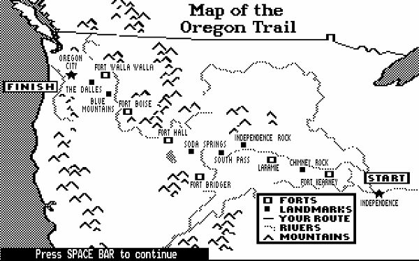
For those who grew up in the 80s and 90s, hearing the mention of “the Oregon Trail” brings back childhood memories of sitting in front of a computer screen – not sitting in an American history class. For those who grew up in the 80s, the mention of this video game brings to mind a slightly-pixelated black and white image of a Conestoga wagon pulled by oxen carrying a family of pioneers whose fates were controlled by the very hands that rested on the keyboard. Personally, The Oregon Trail was the only video game I every played and the Fifth Edition (2002) was much more colorful, cartoon-like animations than the original version. I can still relate, however, to the slightly pixelated-black and white image, titled “Map of the Oregon Trail,” that I’ve chosen to curate. Since its creation, The Oregon Trail has shaped the historical and geographic imagination of children by exposing them to a narrative of progress that consequently shaped our nation’s identity.

The success of this video game is largely due to how interactive and engaging it is for each player. Oregon Trail was originally created by educator Don Rawitsch who was looking for a more creative way to teach his middle school students about the American Western migration in the mid-1800s. In the 1980s, a Minnesota technology company developed the software for the program, using what was originally intended for a board game as the framework. Since its commercial release on the Apple II in 1985, the video game has been used as an interactive, engaging way of teaching children and adults alike about this period of American history. Starting a new game of The Oregon Trail means jumping into a virtual world to journey in a covered wagon across America’s Western frontier while still sitting in front of your computer screen.

This digital map in particular captures the essence of the game: to make an abstract simulation of the challenging and risky journey that pioneers faced on the Trail. What makes it even more captivating is that recreates a reality for each player that some 200,000 pioneers faced while trekking across America in the mid-1800s. It simultaneously recreates and reduces this reality, effectively trivializing this time period for the video game’s primary audience: children. It still, however, reveals some of the more unpleasant realities that the pioneers faced, such as when the wagon fords a river and its passengers drown tragically, or when pioneers suddenly, and uncontrollably, die of cholera. The video game, and map, looks even more realistic because the interface incorporates historically accurate data and geography, including the maps of the Oregon Trail that served as a model for the “Map of the Oregon Trail.” Therefore, in referring to this map I am also including the maps that were sourced to create it.

Wood said, “maps give us a reality that escape our vision…” (5). They allow us a glimpse into the past that we no longer have access to. We do, however, have access to all kinds of historical documents such as public records, journal entries, photographs, and maps that create a narrative of our past that we can understand and even relate to. At the same time, Wood also reminds us that we must use a critical lens in analyzing this map. It is important to understand that while the video game is interactive and allows players some control in its progress, they are also playing within the framework created by Don Rawitsch. We must focus on how the cartographer’s “interests” have crafted this framework and how the player is being exposed to his ideologies.

More specifically, these “interests” are Don Rawitsch’s set of values about American history and our national identity. Thinking about it from this perspective, the map is essentially a revision of the American history in the mid-1800s from the perspective of an American middle school history teacher in the 1980s. It looks at America in the 1850s, when our nation was a struggling provincial power, as an international power that has now fulfilled Manifest Destiny and expanded outside of its boarders during the twentieth and twenty first century. An analysis of this map reveals that the ideology promoted in this video game is that Western expansion was an inevitable journey towards progress. Since the map is a context-bound document, we should consider its historical background in order to reveal this hidden ideology.

One flaw of this map is that it is understated in terms of detail. It is simplified by the black and white color scheme, elementary shapes used for the five symbols in the legend, and bold print that labels the “start” and “finish” box on the Atlantic Coast and Pacific Coast, respectively.  The line at the bottom left, “Press SPACE BAR to continue”, immediately reminds us that we are looking at an interactive map. You are in control of the route that is drawn across the map as your pioneer figures journey from Independence, Missouri to Oregon City, Oregon.

Another flaw of this map is it portrays the relationship between the mostly white male pioneers and Native Americans as friendly and non-violent, completely dismissing the tension between these two cultures that escalated as white settlers pushed further West. It captures this period of aggressive land expansion characterized by white male dominance, though fails to reveal the devastating effect our presence in the West had on Native American culture. It also ignores the fear that pervaded settlers towards a culture that was portrayed maliciously and, therefore, terribly misunderstood. One symbol on this map that may allude to this tension is the presence of military forts, which usually began as posts that sold supplies to pioneers. When they eventually became established towns along the Trail, they often pushed out nearby Native American tribes from the community. This example illustrates Harley’s idea of silences, where maps exclude details that undermine the cartographer’s interests.

These silences are problematic because they contribute to an incomplete narrative of America in the mid-1800s. The map leaves out how the shaping of our national identity consequently had a negative impact on other cultures and the landscape during the same period. It fails to give a full picture of American expansion during this era; however, the lack of detail is appropriate, if not necessary, for the video game’s interface and its target audience, middle school students. Here in lies the challenge of creating educational tools such as interactive maps in video games: choosing what to include and what not to include. Thus, to analyze this map, we must primarily think about why the cartographer chooses to include certain information about a historical event or time period over other information.

Though it contains hidden ideologies and certain silences, “Map of the Oregon Trail” is still an effective tool for teaching children about American history. Rather than ruining a childhood memory, critiquing this map has only emphasized that behind every perspective on history lies an ideology that must be viewed contextually for a greater understanding a historical event or time period. Oregon Trail, as it has already proven, has the potential to teach players about the American Western migration in an interactive, engaging fashion for generations to come.


Works Cited

Scimeca, Dennis. “Why Oregon Trail Still Matters.” The Kernel RSS. N.p., 17 Aug. 2014. Web. 26 Sept. 2014.

Wood, Denis, and John Fels. The Power of Maps. New York: Guilford, 1992. Print.

Grosvenor, Emily. “Going West: The World of Live Action, Competitive Oregon Trail.” The Atlantic. N.p., 25 Sept. 2014. Web. 26 Sept. 2014.


This blog, Map Fail is a collection of erroneous maps. Each post highlights a mistake, for example, when a country isn’t where it’s supposed to be or when information is misrepresented.

http://mapfail.tumblr.com

West Point Military Academy has a nice collection of historical atlases on its Department of History website that show political and cultural conflict from Ancient Warfare to the First Gulf War.

http://www.westpoint.edu/history/SitePages/Our%20Atlases.aspx

Posted in Atlases of the Week, Maps of the Week | Tagged , , , , | 2 Comments

Current World Illicit Trafficking


            Regardless of the morbid content it holds, the chosen map is fascinating for charting black market activity worldwide.  While there is a distinctive lack of common cartographic labels for countries, the map remains intricate through projecting trade routes of four illegal commodities and growing areas for two supply plants.   The data itself is aged, being released in 2000 as a component of a National Intelligence Council release.  A collaborative effort of the NIC, CIA, and non-government scientists from universities or research institutions researched the original product.  Their report is designed as a projection for the state of the world in 2015, encompassing the rapidly expanding population of megacities in addition to predicting availability of water.  The Illicit Trafficking map is created to illuminate the international state of black market trade while simultaneously inundating the reader with the scale of the problem.

The map’s data strongly favors the visual and symbolic rather than textual.  Four different colors represent cocaine, heroin, illegal migrants, and women & children, with several hubs around the world for a mixed variety of these products.  Using both intuition and a labeled world map, Columbia is a nexus for cocaine production.  In creating the map, the researchers used an overwhelming network of arrows to emphasize the strength of the drug trade extending across the borders of the world.    Additionally instead of arrows, there are cores of growth scattered throughout the continents.  Coca is plentiful in the Columbian region, bringing logic to the mass of green arrows that form a spider web across Central American and the Atlantic Ocean to both Asia and Europe.  The northeast border of South America appears to have a very enthusiastic cocaine trade, for it is the only region solidly colored in on the map.  However, following the same path as cocaine into the United States is the influx of illegal migrants from South America. When juxtaposing these two routes the immigrants seem rather docile next to the network of illegal drug trade, highlighting one of the map’s flawed representations.  To consider illegal migrants as having the same paths and mindset as drug traders is detrimental to their population.  In addition to the flow out of South America, the southeast region of Asia is brimming with opium poppy plant farms, giving some validity the area’s nickname as the “Golden Triangle” of heroin.  The trade of heroin can be traced across Asia and the Pacific Ocean.  However the Triangle is not limited to simply the export of heroin, as the routes of women and children spread up to Japan and cross the Indian Ocean.  Again comparing to a traditional world map, another major port of black market trade can be found in Nigeria, where there is a plentiful flow of cocaine and heroin from South America and Asia, and an appropriately energetic export to the United States’ east coast and central Europe.

These frequent comparisons to a standard world map highlight a major flaw in the structure of the NIC map.  The mass of detailed arrows is an excellent consolidation of massive collections of data, yet their effectiveness diminishes without country data to accompany it. Therefore without consulting outside sources, the map is useful at only observing broad regional trends.  For example, Germany appears on the map unnamed, but a repository for all four trade factors examined.  As a result when referring to trade only generalizations such as “central Europe” can be used to quantify the trade routes.  Leaving the country names off the map was a deliberate choice by the group of cartographers in construction, intending to avoid rendering the map excessively cluttered.  Even in its current state it is difficult to read at times, in particular at the most active trade sites in Central America and Eastern Europe.    Their choice is enigmatic, adding a layer of confusion for the sake of reducing potential confusion.  For Central America in particular, the diverging mass of arrows used highlights the cartographer’s intentions to emphasize factors that the map’s supporting U.S. government institutions believe to be the most critical.  In the end their decisions are justified, leaving the map legible and coherent after labeling only the oceans.  While leaving the oceans labeled is likely a result of having more working space, it is also a reflection of desires to express the international scale of this trade and the effect it has on each continent.

In creating this map, the NIO, CIA, and the assisting institutions had precise intentions of what were necessary targets to highlight.  As a result highly addictive drug production and distribution was illustrated alongside human trafficking and illegal migration.  While the three primary trades are vastly different from each other, this illuminates the logic behind their choices.  For example, if all trade routes were of drugs the map would have little depth, being pigeonholed into a preexisting mass of War on Drugs propaganda.  Instead the audience is presented with a rich map enumerating the government’s foci of primary interest for the future.  The NIO’s map is carefully detailed and intricate, emphasizing that the span of the black market is global, crossing borders and touching nearly every major country.

Works Cited

US Government. “Current World Illicit Trafficking.” University of Texas Libraries. N.p., n.d. Web. 19 Sept. 2014.


Historical Atlas of the Holocaust. N.p.: Macmillan, 1996. 252. Web. 3 Oct. 2014. <http://we4mf3mv5e.search.serialssolutions.com/docview/38906638?accountid=14731>.

The atlas encompasses the entire span of the Holocaust, starting from the earliest actions of Nazi Germany into their final days.  Some unique maps included are different from the traditional Allied perspective, and instead include some Axis maps.  One in particular details the size of the Jewish population remaining in every European country.

Esposito, Vincent J. The West Point Atlas of American Wars. New York: Praeger, 1959. Print.

This is one of the older texts that was readily available in the maps section of the library.   True to its military background, it gave extraordinarily detailed accounts of United States warfare.  The information encompasses even the civil war, where troop movements were charted.

Posted in Uncategorized | Comments Off on Current World Illicit Trafficking