
Throughout the first six weeks of this course, The Rhetorical Lives of Maps, we have focused on how maps have much more meaning than just giving directions, and how they can tell a story. This was exemplified within the first few days of this course when we were assigned to create our own map by picking the five most meaningful locations from our hometown and explaining the importance behind each spot. Despite these presentations only being five minutes, I was able to learn so much about my classmates and gained a piece of who they were; maps tell stories and the cartographer is the author.
The creator of this map of the week, John G. Drury, realized the “power” of maps on his ship back to America after being stationed in Okinawa, Japan during WWII. Drury enlisted late into the war, in 1943, and was stationed as a technician in Okinawa after the U.S. won the Battle of Okinawa. This three-month battle had the highest death toll of any battle in the Pacific and was the last big battle of the war. Tragically, the reason this battle had the highest death toll is because rather than surrender, most Japanese soldiers either fought to the death or committed suicide rather than be in American hands. More than one-third of the civilian population of Okinawa died either from being caught in the crossfire or from committing suicide once the Americans took over. One American soldier even said that Okinawa left him with “the most tortuous and persistent of all the ghastly war nightmares that have haunted [him] for many, many years” (The National WWII Museum).
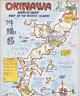
Despite all of the horrors Drury and the rest of the soldiers faced while stationed in Okinawa, during his free time on his trip home, Drury was inspired to create his own map of the Japanese island; however, he exchanged the bloody battles and chaos for more positive, eye-catching images of landmarks and vivid colors that include a boat labeled “a stones throw from Tokyo,” a traffic circle, and a “native hut.” All of his buddies on the ship took a keen interest in this map, so Drury had an idea. He made the maps customizable, by composing the legend out of symbols that each soldier could draw on their map. These symbols included places where they landed or departed from, where they were stationed, and where they had advanced or had movement. The idea of replacing the tragedy with more tangible things like the soldiers’ ships and dates was a way of coping with all of the deaths they had witnessed. Despite all of this, the map didn’t encourage the soldiers to completely forget those who had sacrificed their lives for their country, as it also included landmarks like the 77th Division Memorial, many airbases, and even the caves where U.S. and Japanese soldiers alike hid and fought. Drury called these maps “Mem-O-Maps”, something for the soldiers to remember their time spent at war with.
By the end of their journey, Drury had sold 232 copies of his map to the other soldiers on his trip, and he was inspired to make a business out of it. He and his partner, Corporal Richard G Bryant, converted Drury’s garage in North Hollywood into their studio and they got to work. They drew more maps of Okinawa and then new maps of the Philippines, Oahu, Japan, and the European Theater of Operations. Although there are a couple of conflicted copyright dates, these maps are presumed to have been published in early 1946. The pair advertised their new company “through American Veterans’ associations and the American Legion Magazine” (Barron’s Maps). They had the tagline “YOUR SERVICE – A MAP RECORD – with places you won’t forget if you live to be a thousand”. All of their maps overlaid amusing images and “memorable” landmarks (like strip clubs and bars that the soldiers often visited) over the true geography of the land. One European map even had a man peeing on Germany, either to comically show their distaste for the country and/or to represent many head figures such as Winston Churchill and US General George S Patton when they “relieved themselves” on German soil after their soldiers had won land-gaining battles.
“Mem-O-Maps” was a hit, and they continued to be popular into the late 1970s. Although their business died down decades after the war, these maps can still be found in the homes of WWII veterans and their families to document the bravery and commitment these soldiers gave to our freedom. These maps spoke to the soldiers (and honestly any other viewer) because they didn’t just document the land, but each location that a soldier customized onto their map represents a chapter of their life, one that they will never forget if they live to be a thousand.
Maps like Mem-O-Maps are so influential because they acknowledge the terrible history behind the map, however, they help potentially traumatized soldiers remember their time at war in a more personalized light-hearted way. The “Mem-O-Map” is just one example of how maps can have so much more meaning than just giving directions or displaying locations. They record history (even subjective history based on the cartographer). They contain memories and are able to share these memories for decades to thousands of years (much longer than the author can). They give the reader historical insight into the time. Lastly, based on what the author merits to be important enough to document on the map, they give the reader a glance into the mind and values of the cartographer. Maps can tell complex stories, but it is up to the reader to recognize them.
Works Cited:
Givens, Adam. “Okinawa: The Costs of Victory in the Last Battle: The National WWII Museum: New Orleans.” The National WWII Museum | New Orleans, The National World War II Museum, 6 July 2022, www.nationalww2museum.org/war/articles/okinawa-costs-victory-last-battle#:~:text=So%20close%20to%20the%20home,disaster%20for%20civilians%20as%20well.
“Map of the Week.” Map of the Week, University of Richmond, 11 July 2017, mapoftheweek.blogspot.com/search/label/military.
“The Mem-O-Maps of John G Drury, 1945-46.” Barron Maps, Barron Maps, 25 Jan. 2017, barronmaps.com/the-mem-o-maps-of-john-g-drury-1945-46/.
Atlas Link:
https://www.loc.gov/collections/general-maps/articles-and-essays/general-atlases/ortelius-atlas/
The Theatrum Orbis Terrarum was first created by Abraham Ortelius in 1570 and is generally regarded as the world’s first true atlas (or compilation of atlases). It was originally written in Latin and was a collection of 70 maps on 53 sheets of paper. What’s unique about this particular atlas, other than its incredible accuracy for the time, is that the majority of the atlas were based upon sources that no longer exist today.
Blog link:
I found this blog fascinating because it focuses on exactly what this assignment (and class) entails. It has a “map of the day” page where the creator, Jonathan Crowe, either finds or picks from an outside submission a map that defies the stereotypical map.
This map is an interesting take on wartime mapping. The map throws out most previous notions of standard cartography in favor of personalization. It’s also interesting how they were sold more commercially for pleasure and comfort rather than for strictly education like most maps. I like how you related the map to the hometown assignment we did earlier in the year because maps definitely can be personalized to have meaning to the cartographer. The point you made about how the map is a tool for remembrance but also for mourning the losses on both sides is spot on, and I also like how you made the point that these memories can never be forgotten.
I really enjoyed this choice of map because of its interesting historical context as a map that came as a product of a war rather than the more common war-time map. One area in particular that I enjoyed was the part about the soldiers adding their own personal details and points of interest to their maps. This is a great instance of the benefit of the subjective nature of maps and the ability to utilize cartography to map an area in an infinite of number of unique ways. I think this map is an excellent example of the power of maps to influence our perceptions of places and events. You made a great point about how the creation of these maps was likely a really effective coping mechanism for the soldiers, and I think this reflects on the way cartography helps shape our thoughts and contextualize information.