
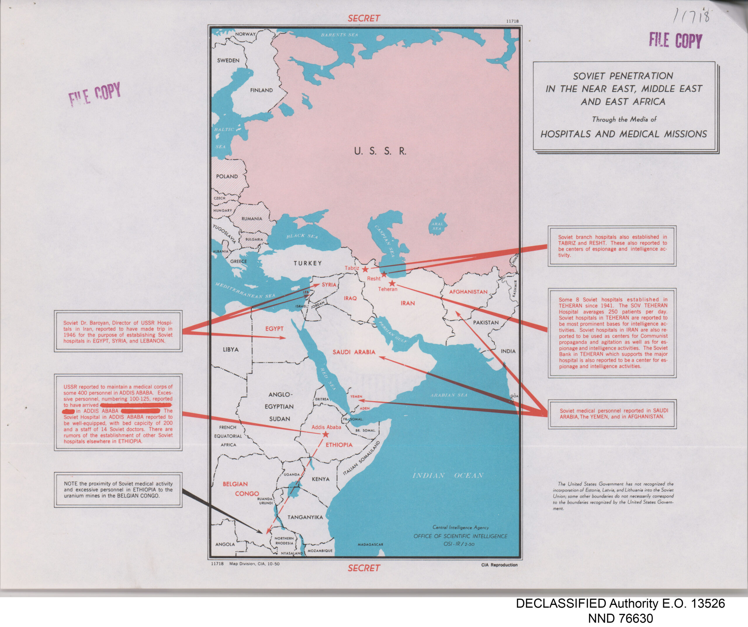
Whether it was espionage, space races, or the Red Scare, Americans have been fascinated, and at times terrified, by the formation of the Union of Soviet Socialist Republics (USSR). While most of the understanding we have from the time of USSR’s prominence is to-an-extent fabricated from Hollywood, there still was a level of intense intelligence work that was classified to the public. The featured Map of the Week, “Soviet Penetration in the Near East, Middle East and East Africa Through the Media of Hospitals and Medical Missions,” was published as a Classified Document by the Central Intelligence Agency (CIA). This map contains a “perimap” that includes more than the actual map itself. It is composed of the map, arrows, and texts. All these aspects of this perimap, work to create a code of what the CIA was thinking and going through at the time of the creation of the map. This helps us to better understand the geopolitical tensions that still exist today between the two countries that were built throughout the Cold War.
The United States (US) and the USSR, alike, used several, sometimes questionable, methods to gain intelligence on the other. This intelligence was gathered as a part of the Cold War, which included an arms and space race, to try to stay one step ahead of the other country, whether that was ahead technologically or in security. The USSR, due to its authoritarian state faced less push back from the public and court system for its intelligence-gathering techniques. This meant that the USSR had the uninterrupted ability to conduct covert operations on several countries, including Ethiopia, Iran, Afghanistan, and South Yemen, which all are represented on the posted map.
This is where American Intelligence services come in and form this map. The creator of the map was the CIA and everything on the map was chosen to be there through careful deliberation. For instance, a large majority of known Soviet intelligence hubs are now connected with Soviet ran hospitals on the map. This connection, while factual, also forms the relationship in the viewer’s head that they are in some way connected. Even the scope of the map helps to set up relationships between the marked countries because they are seen on the same plane. Furthermore, the map shows the extended relationship of Soviet hospitals, Ethiopia intelligence, and the location of uranium mines in the Belgian Congo. One also must remember during this time that most of the Soviet hospitals that the public would hear about in America was filled with horror stories. Soviet hospitals would service political dissenters and prisoners through methods of abuse, drug usage, and experimentation. This map would paint a very different picture in the 1970s as opposed to modern day. In the 1970s, this map would represent the fear of Soviet intelligence and indoctrination growing in our world. Today, socialist hospitals generally take on a different image, one of free healthcare for all.
This is not to say that there is no connection between Soviet hospitals and gathering intelligence, as these hospitals were widely known to be highly interconnected within the government. It instead proposes a new way of thinking. Maybe a map was what the Americans needed to see the connections between the two. Maps set people up to think in terms of relations and correlations, the danger lies when there are cases of correlation being misunderstood for causation. Looking now at the present, there has been many instances of these charted relationships becoming true. Ethiopia and Russia continued a partnership with each other that started in the late 1800s and has grown to include the joint mining of uranium in Ethiopia’s neighboring nations, just like the map suggested.
It becomes clear that the makers of the map wanted to show what the agreed upon “facts” were, and maps have the special power to be able to do so. When a map is made, it is taken to be factual, when maps can be political and manipulative. There is a note at the bottom of the map that reads “The United States Government has not recognized the incorporation of Estonia, Latvia, and Lithuania into the Soviet Union…” In other words, while the US Government did not acknowledge the growth of the Soviet Union, the CIA does and because they are the ones that put it on the map, they took a political stance saying that this is what should be believed. It should be noted that because this map was classified, it was only available to a small group of people meaning its information wasn’t, at the time of publication, open to the general public. The secrecy of the map is even more intriguing because it shows the government controlling what information is exposed to the government. It shows the audience today that the US Government most likely agreed with the map behind closed doors and the increasing threat of the Soviet Union, but simply did not want to spread widespread panic on the issue. One can imagine a world where this map was freely published during the Cold War and the fear and panic that it would’ve brought to the masses truly demonstrates the power of maps.
Works Cited:
“Ethiopia, Russia Enter New Frontier.” AllAfrica.Com, 5 Apr. 2018. ProQuest, https://www.proquest.com/docview/2023435410/citation/58E1ACED5BAD417DPQ/1.
“Mind Destruction in the USSR.” National Review, vol. 31, no. 43, Oct. 1979, pp. 1347–48.
National Archives NextGen Catalog. https://catalog.archives.gov/id/175514357. Accessed 11 Oct. 2023.
Stack, Kevin. “The Cold War Intelligence Score.” American Intelligence Journal, vol. 18, no. 1/2, 1998, pp. 69–72.
“The Essence of the Soviet Health System.” American Journal of Public Health, vol. 107, no. 11, Nov. 2017, pp. 1736–38. PubMed Central, https://doi.org/10.2105/AJPH.2017.107111736.
Blog of the Week: https://catalog.archives.gov/id/305945
This link connects to a collection of archival declassified CIA Maps from 1947-2015.
Atlas of the Week:
Woodbridge’s Larger Atlas: Atlas On A New Plan, Exhibiting The Prevailing Religions, Forms Of Government, Degrees Of Civilization, And The Comparative Size Of Towns, Rivers And Mountains
This atlas would typically be used in schools to show different religions in relation to geography. The various maps have several legends to show which populations practice which religion. The atlas was published in the 1820s, but the exact year is contested between 1821 and 1824. Throughout the atlas, the word choice shows and reaffirms students the ideals of xenophobia and racism. One map explains how lower classes are often unsophisticated and ignorant. Additionally, the atlas generally favors towards Christianity , often using the terms “barbarous” and “pagan” interchangeably. This atlas is useful to understand how and why people in the 1800s thought the way they thought, including general public morals and beliefs.
Amazing job Grace! I really liked how map exploration provides an amazing glimpse into the world of Cold War intelligence and the power dynamics between the US and the Soviet Union. The classification of the map adds mystery and emphasizes the great nature of geopolitical moves during the Cold Era. I loved your insight into the changing perceptions of Soviet hospitals over time. The map, which reflected 1970s fears and concerns, painted a different picture than current associations of socialist healthcare as it focuses on the changing narratives and ideologies surrounding specific symbols, such as hospitals, in the context of global politics. The note you added about the non-recognition of certain countries’ incorporation into the Soviet Union, which highlights the agency behind map-making and highlights the understanding that maps can be political and manipulative. The classification and restricted accessibility of the map highlight the government’s controlled information leaks during the Cold War and highlight the relationship between public awareness and secrecy. Overall, I really enjoyed reading your map of the week and amazing job!
Incredible work Grace! Your post was useful to me as I didn’t know that building hospitals abroad was a way of getting intelligence. I believe this is one only maps about the Cold War I have seen so far that isn’t propaganda. As the map wasn’t published to the public, there was no one to convince or scare, so the map must be true as it served as intelligence.
Moreover, I found your mention of the non-recognition of countries as a part of the USSR very interesting. This clearly shows that governments purposefully conceal information that could impact the people, or that they could purposefully hold positions that contradict reason or the common good.
Finally, I took a look at the Atlas you included, and I have noticed that called Christianity in East Africans as “Corrupt Christianity”, which I believe shows that at that time, maybe because of East African’s skin color or because of their culture, they were not considered by European Christians as legitimate worshippers or followers of their faith.
This is a very good analysis of the map, Grace! I agree this is a big piece of propaganda. I don’t understand why they would keep this a secret considering it was propaganda. One thing I want to point out is the hypocrisy of the U.S. because they spread the propaganda of how Soviet Union uses horrible torture methods in these hospitals to gain intelligence, when the U.S. does the same. Which could also be something that they kept quiet like you mentioned in your last paragraph. I find the soviet hospitals in Ethiopia interesting because I want to know the lasting implications that it has on Ethiopia itself. This partnership between the U.S.S.R and Ethiopia is something I haven’t heard of even though my parents are Ethiopian, but the socialist ideals that Ethiopia has been run on could be from the influence of the U.S.S.R. Excellent analysis, Grace 🙂