
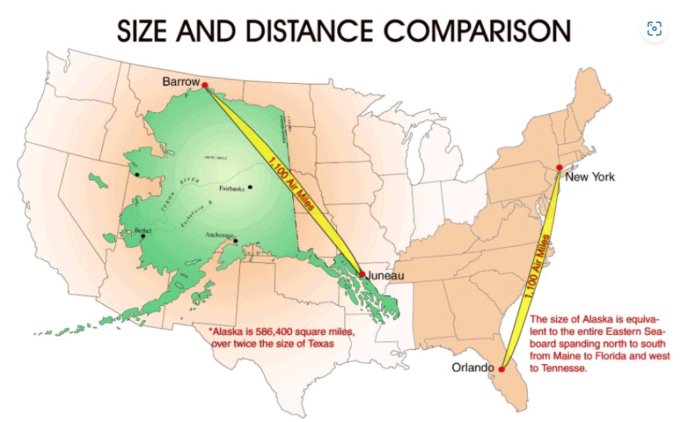
When viewing the Mercator Projection of the United States map, how often do we consider the relative sizes of the fifty states? This map presents a graphic illustration of the size of Alaska in comparison to the entire continental United States. Alaska is 586,400 square miles, which is over twice the size of Texas. The length of Alaska is equal to the entire Eastern seaboard spanning from north to south from Maine to Florida and west to Tennessee. This raises the question, other than its massive size, why was the United States interested in making Alaska the forty-ninth US state? To examine this question, we need to look into the history, natural resources, and geographical location of Alaska.
The history of Alaska reveals why the US became interested in this faraway land. The Russian Empire first colonized Alaska in the late 1700’s. However, the Russians had difficulty maintaining this vast territory and feared losing the land to Great Britain in the future. The Russians viewed the United States as a potential ally. Therefore, they agreed to sell Alaska to the United States in 1867 for 7.2 million US dollars, equal to 2 cents per acre. Alaska, the largest state in the nation, was once referred to as “Seward’s Folly.” Members of Congress ridiculed William Seward, the United States Secretary of State who pushed for the purchase of Alaska. When the potential purchase of Alaska was discussed, several politicians and journalists were opposed to what they called a “barren wasteland.” During World War II, America realized Alaska’s importance for national defense. In 1942, the Japanese took over two of the Aleutian Islands but were driven back by US troops. This led to the construction of military bases in Alaska and a highway that connected Alaska to the US mainland. Alaska became the 49th US state on January 3, 1959. Today, Alaska provides a place for air and missile defense for the nation.
Located on the northwest point of North America and in close proximity to Russia, Alaska’s geography was a major consideration for statehood. Alaska is bordered by Canada on the east, the Arctic Ocean in the North, the Bering Sea to the west, and Pacific Ocean in the south. This consists of 36,000 square miles of coastline. The Bering Strait is home to two major shipping routes, the Northwest Passage and the Northern Sea Route. The largest city, Anchorage, is less than a ten-hour flight to Tokyo, Frankfurt, or New York City, providing quick transfer for air freight. As a result, Ted Stevens International Airport in Anchorage is one of the busiest cargo airports in the world.
A major motive for the United States to grant statehood to Alaska was its vast natural resources. Oil was first discovered here in 1957, and Alaska now contains the largest oilfield in North America which covers over 200,000 acres. There is more than twice the amount of oil in Alaska than the next largest field found in Texas. Nonrenewable resources are mined throughout Alaska. The Red Dog Mine is one of the world’s largest zinc mines, the largest known graphite deposit in the world is found at Graphite Creek Prospect, and Ambler Mining District contains large copper-cobalt deposits. Alaska is the second most gold producing state with five major mines and also excavates a significant number of rare earth elements (REE). Over half of Alaska is made up of federally owned national forests, national parks, and wildlife refuges. Tongass National Forest, which covers over seventeen million acres in southeast Alaska, extends over five hundred miles in length along the Alaska panhandle. The second largest national forest in Alaska, Chugach National Forest, curves around Prince William Sound and covers over five million acres.
The word Alaska comes from the Aleut word alaxsxa, which means “great land.” When Alaska became a state, it increased the size of the United States by nearly 20 percent. This fact is clearly supported by the visual provided by the map. Other states appear insignificant when compared to Alaska. The image of Alaska projected over a map of the forty-eight states seems to glorify its size. If Alaska were not so big, would it have become the forty-ninth state or would it have been overlooked? However, the geographic location of this state and the valuable assets it possesses seem to be more important than size. But because of its size, it can supply more of everything – more oil, more coal, more trees, and more coastline. So perhaps Alaska’s acreage wins out.
Works Cited:
“Alaska Maps & Facts.” WorldAtlas, WorldAtlas, 7 Mar. 2023, www.worldatlas.com/maps/united-states/alaska.
“Alaska.” Encyclopædia Britannica, Encyclopædia Britannica, inc., 18 Oct. 2023, www.britannica.com/place/Alaska.
Alec. “33 Maps That Explain the United States Better than Any Textbook.” All That’s Interesting, All That’s Interesting, 24 June 2021, allthatsinteresting.com/maps-that-explain-america.
“Battle of the Aleutian Islands.” History.Com, A&E Television Networks, www.history.com/topics/world-war-ii/battle-of-the-aleutian-islands. Accessed 21 Oct. 2023.
“Top Five Gold Mining States across the US Profiled.” NS Energy, 11 June 2020, www.nsenergybusiness.com/news/top-five-gold-mining-states-us/.
Blog Link:
100 Amazing Maps of the World | Far & Wide (farandwide.com)
This blog includes several unique maps displaying random data from the United States and worldwide.
Atlas of the Week:
For my Atlas of the week, I chose the Digital Atlas Project which contains a variety of themes of world and regional maps. Categories of maps include demographics, urbanization, climate, and geopolitics. Within these categories, additional information is provided on trends and relevant data. Many of these maps are interactive, allowing the user to focus on a specific location or time period. A particularly interesting map found under the demographics theme is an interactive world migration map showing net migration of countries throughout the entire world.
This map stuck out to me initially because although it is common knowledge that Alaska is the largest of the 50 states it is seemingly never put into comparison. I thought it was a great point that Alaska was used for national defense during WW2, and I think that this same logic should apply to both the Cold War and even current times. The presence of a large piece of U.S. land so close to Russia is extremely helpful for proximity and makes threats of nuclear/missile strikes more viable. The United States has used Alaska’s land as a military tool for a long time and the size of the state is yet another important factor in this.
The map was so shocking to me because I had never seen the size of Alaska being compared to the entire United States. I knew it was the largest of state by a decent amount but this map really puts its size into perspective. I like how you brought the history of Alaska and its purchase by the US into your analysis because it brings to light the significance of the territory and again its enormous size. I thought that the comparison the map made with Alaska being equivalent in size to the entire eastern seaboard was so important for the map because it further adds to the land representation. When I looked at this map the first thing I thought of was the Mercator Projection that we looked at in class and which you happened to also point out. This is because it was the first map that accurately displayed countries and continents’ sizes on a map which is what this map is doing with Alaska and the United States.