
The map I have chosen may not look like much, but its details and the rich history behind it help give appreciation and meaning to the U2 program. (And no, this is not a map of Bono’s U2 world tour or anything like that.) Getting an insight into one of the countless clandestine, Cold War-era CIA missions is a great privilege. Before discussing the intricacies of this map, however, it is necessary to understand the context of these U2 operations and what these developments meant for the trajectory of the United States. For this, I will be referencing “The CIA and the U-2 Program, 1954-1974,” a declassified internal CIA report. While this report has been declassified since the 1990s, the map in question only became open to the public in 2013, over twenty years later.
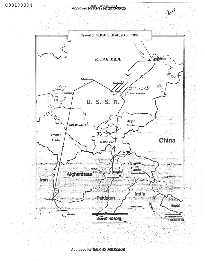
A comprehensive program aimed at reconnaissance worldwide was launched by the CIA in 1956, utilizing the new technology of the U2 plane. Reaching altitudes of 70,000 feet, this plane could often travel very far while still evading enemy radar detections and taking detailed pictures from above. Pilots were even required to wear spacesuits while riding. Launched during the Eisenhower administration, these maneuvers helped put the United States “on top” because the technology was unrivaled even by the Soviets. “Operation Square Deal” in 9 April 1960 was the last successful mission against the Soviet Bloc before the anti-Soviet recon program was ceased following a U2 plane being shot down by Soviet missiles. Former Soviet Premier Nikita Khrushchev noted in his memoirs that, but for an error, the 9 April plane would have promptly been shot down. Now that some of the map’s history is put into perspective, a deeper analysis of its details, silences, and implications can be conducted.
“Operation Square Deal” appears very plain due to its lack of color and overall simplicity, though this visage really just masks its strategic approach and shows how a map can mislead its readers. From first glance, you can clearly tell the direction/trajectory of the plane, which departs from Peshawar, Pakistan and lands in Zahedan, Iran. The bottom half of the map is shaded while the U.S.S.R. is not, which could be intentional. Soviet cities along the path of the U2 likely represent the key points of interest for the mission, as every city listed in the U.S.S.R. is directly in the plane’s trajectory and most in the bottom half are not. In the bottom left of the map is a line representing scale in both kilometers and miles. The decision to include the bodies of water and their names on the upper half of the map is an important decision of the CIA cartographers that could be interpreted differently depending on the reader. For the targeted audience of CIA members and U2 pilots, these inclusions would probably just serve as notable geographic reference points, while a civilian reader may not see them as strategically.
While this map appears rather innocuous, there is undoubtedly more than meets the eye, chiefly concerning implication and intent. It resonates an aura of science and veracity, offsetting the obvious bias ingrained within its confines due to its being a direct production of the U.S. government. Photography from such high altitudes tends to mask the conscious decision of what is being shown with the unconscious scientific truthfulness that tends to be associated with these pictures. This form of cartography seems less likely to manipulate than a hand-drawn map because technology seems to separate itself from human folly and prejudice. Despite this, the map itself is not a photograph from a U2 plane so it does not intend to be a perfect representation of this Asian sub-region. Instead it focuses on borders and significant landmarks pertaining to the mission. The U.S.S.R. is centered and positioned in such a way that it immediately catches the eye with its larger font and spacing between letters. Its representation is meant to be daunting, as its reality is a direct threat to the mission path and objective. The vast expanse surrounding the Soviet Socialist Republics and lack of cities labeled in this region – including China – seems to indicate an “all or nothing” approach relating to the clandestine nature of the mission at hand. It is truly deep within enemy territory, even if it is tens of thousands of feet in the sky, implying the importance of sticking to the mission at hand – pure espionage.
The establishment of the United States as a global power is a crucial detail reflected in this depiction of U2 routes. The plane, and likewise the country it represented, were capable of winding around and maneuvering the great deal of the region with ease, certainly not allowing any overarching confinement from the USSR. The delineation of Pakistan and Iran as the takeoff and landing zones, respectively, helps shed light on the relations these countries had with the United States at the time this was drawn. An American military base had to be present in both countries simply due to the gravity of the U2 program missions – no pun intended – and their highly classified nature. It is now quite evident that the U2 plane was used not just in these areas, but throughout the Middle East. Whether this was predominately during periods of conflict or simply to stay up to date on British and French activities is debatable, however the “all-seeing eye” of the U2 plane was and in many ways still is a vestige of US containment of Communism. This anti-Soviet movement dominated US policy from Truman throughout the Cold War and helped amass a great deal of tension between the “Western world” and its rivals.
The US government has used a wide variety of methods within this map itself to portray a fight against the evil and inferior Communist ideology and the US effort of spreading peace worldwide. This map cynically portrays Communist nations and their prevalence and in turn displays both the threat to Western democracy and the fortitude that democracy has shown. Maps have an often overlooked yet incredibly important power in advancing a state’s strength and agenda through the (perhaps photographic) lens of reality, which certainly influences the reader and calls for reaction or sentiment in often unexpected ways.
Bibliography
Gregory W. Pedlow and Donald E. Welzenbach, “The CIA and the U-2 Program, 1954-1974” (Central Intelligence Agency, 1998).
“Synopsis: The CIA and the U-2 Program” (Central Intelligence Agency, last modified March 19, 2007).
-Bryan C. Carapucci
The Square Deal map of the U2 spy plane route is a great choice for map of the week because the U2 plane is a little-known topic for most people. The Cold War era is still very important for today’s international relations and even just studying the changes in our own society over in the post-war years. However, much of this information is still unknown because much of the military and espionage is still classified, such as this very map which was classified until 2013. This shows how important that time period was and how it can still impact us today. The spy plane was the cause of a major incident when Kennedy denied its existence completely just before it was shot down by the Soviets. As Bryan explained the plane on this map could have been the first plane shot down and the source of great tension between the USA and USSR. It is important to note that while this map was not a picture, it still tries to come across very plainly in an unbiased fashion. The picture of earth by Van Sant, as analyzed by Dennis Wood, was published by national geographic which is popularly considered as a trustworthy source for information about the world and nature. Similarly, this map of the spy plane route by the CIA would, to us, have the same level of credibility as being an unbiased view of espionage because this map comes right out of the classified files from the Cold War. The act of concealing through silences in a map is not the only form of deprivation which can fool a reader unknowingly. Classifying a map can hide the same biases as that of a map missing details just by being secretive in distribution. The fact that this map was not available until recently makes us, the viewers of this map, inclined to believe the information on the map as completely factual just because these “facts” had been previously been too important for anyone outside the intelligence community to view. This particular map of the U2 flight pattern is a great example of our Cold War history, but an even better example of the subtle lies that go into producing a map.