
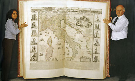
The Klencke Atlas was created in 1660, and is considered one of the largest atlases in existence. The atlas is around 5’9” tall and 6’3” wide when opened. This atlas contains 37 maps that can be removed from the atlas and displayed on a wall. In 2010, the atlas was put on public display for the first time in approximately 350 years at the British Library. This atlas was created to serve as an encyclopedic summary of humanity’s knowledge of the world’s geography at the time of its creation. The immense size of the atlas as well as the wide range of regions it covers, allows the atlas to convincingly suggest that its maps are accurate reproductions of reality. Furthermore, the ornateness of the atlas reminds us of a maps ability to serve as not only a utilitarian object, but also as a work of art.