
by Alex Beran and Abra Granger
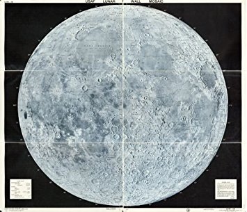
The USAF Lunar Wall Mosaic was created in 1962 and was intended for astronauts to land on the moon. This map allowed the United States to win the space race against the Soviet Union. The ability to win the space race revealed which country had better resources and technology. Astronauts needed to know the exact slope and composition of the surface in order to land on the moon. If a country can map the moon, then it is likely that they can map any other place as well. The power to map the moon is a form of psychological warfare. The moon is way further away from the U.S. than the Soviet Union is. If the U.S. can map and get to the moon, then they can most definitely accurately map the Soviet Union too. Another theme of power is that a country can exert their dominance by “owning” and “naming” territories on the moon.
Lunar mapping began in the 1600s, reached its peak during the space race, and dwindled after the U.S. landed on the moon. Cartographers began mapping this moon using Earth-like techniques which they ditched due to the lack of air and water erosion on the moon. Cartographers, in fact, used airbrushing techniques instead to make the map look less like the earth. To impose a sense of power, a country can express ownership by naming territories on the moon.
In class, we discussed how political power is concomitant with the map’s existence. With questions encompassing what it means to have the technology to map the moon in relation to the concept of a “Space race”, we guided the class through the political power and scientific advances that were employed to carry out the making of the lunar map. Proceeding the warm-up questions, we invited the class to participate in a debate on whether the Lunar Wall Mosaic was more scientific, or more political. This debate furthered the depth of conversation about the overall ideology and context of the map. On the one hand, the map could not have been created if not for the U.S. Air Force’s military agendas. On the other hand, the longevity of the scientific advancements outlive the political agendas of the time. However, we can conclude that both political and scientific influences play major roles in the creation of this map.