
First Map:
Second Map:
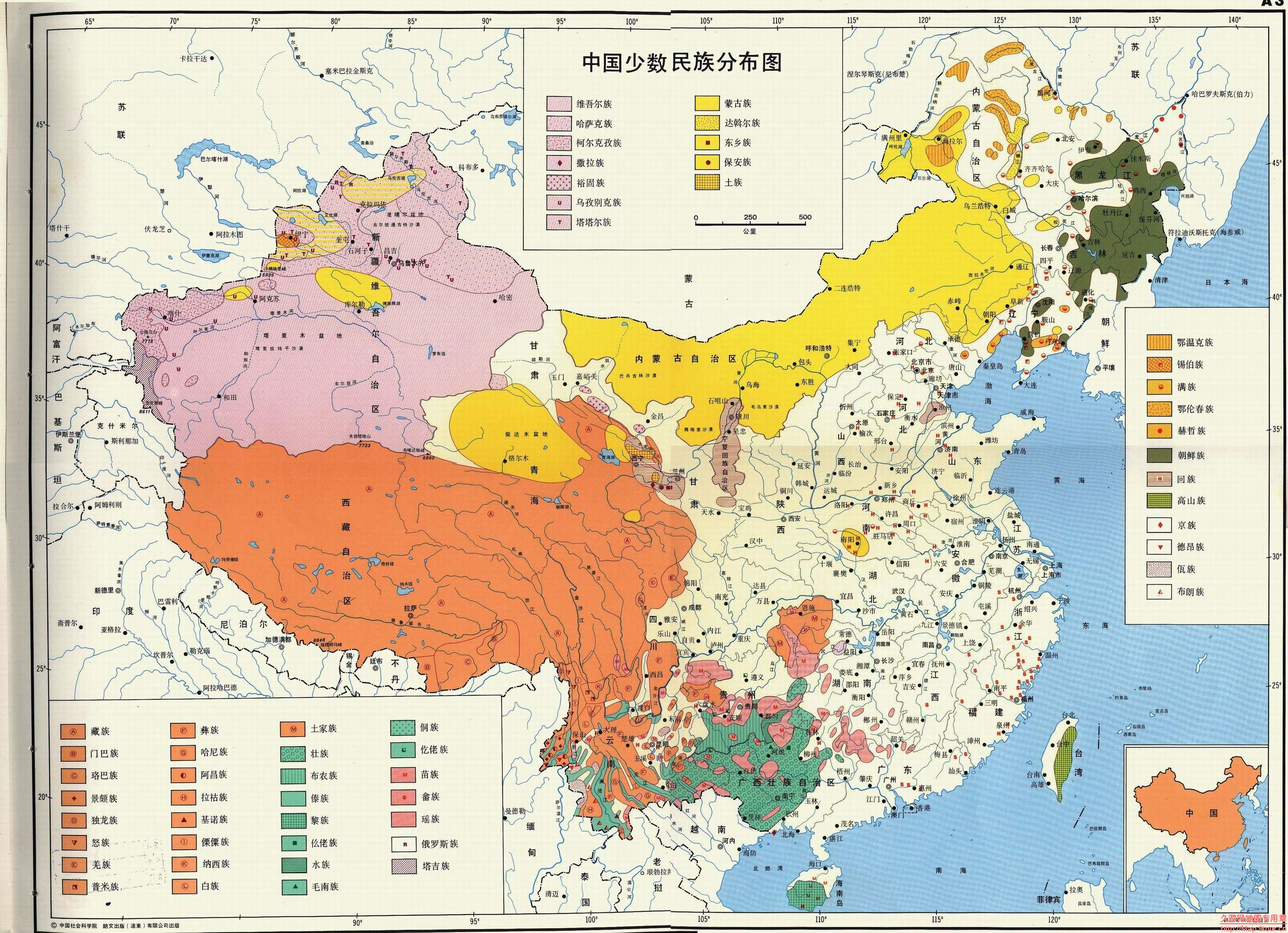
We all know that America is a diverse nation. It embraces people from all over the world. China is also a diverse country, but its diversity is not same as America’s. Even though most of Chinese are yellow race, they are distinctive in their ethnic groups. This is the reason I chose these maps, in order to introduce the special Chinese diversity-the ethnic groups. There are two maps. The first one is the original map of Chinese ethnic groups’ distribution, and the second one is the translated map. I am going to focus on the comparison of these two maps. Maps about a nation can be created by the native people or by foreigners. From various perspectives, the maps can look totally different, and they can be embedded with diverse values. From native people’s perspectives, the map can show more details and reveals more national values, but it also can be misleading. As foreigners, they can make the map straightforward and clear, but sometimes they will leave out important contents, which I will explain more later.
Looking at the first map, which is created by Chinese authors, we can see how Chinese people deal with their own nation’s map. The authors of this original Chinese map may know the pattern that the places where ethnic minorities live are related to geographic environment, so they embedded this idea in the map, which allows the readers see the pattern from the map of the ethnic groups. Therefore, even though this is a map about ethnic groups’ distribution, it also reveals the topographic features of China. In the southwest part of China on the map, there is a mix of green and orange and also many symbols that represent different ethnic groups. That is the Hengduan Mountain Range, which contains many mountain ranges, creating one of the most complicated landforms in China, mostly run roughly from north to south. The distributions of ethnic groups also show the same trend that are mostly in a long shape from north to south. Due to the living environment, people normally lived in the valley, so the mountains cut off the relationship between nearby ethnic groups. It was hard for people who lived in opposite side of mountains to communicate, so then they formed as two distinguished ethnic groups. In this way, the map introduces more information to the readers by suggesting the relationship between ethnic groups’ distribution and Chinese topographic features. However, this information may only allow people who are familiar with Chinese topographic features to see it, so it is not very helpful to other readers.
However, as we all know, every map has its own point of view. Therefore, when Chinese authors make a Chinese map, it is understandable for them to intend to make China look better. When first looking at this map, readers will easily be astonished by how diverse China is. There are 55 ethnic groups showed in the legend. Different ethnic groups are displayed by different colors and symbols. China has 56 ethnic groups in total, including the largest one—the Han ethnic group, which is not showed in the legend. According to the National Bureau of Statistics of China, the Han ethnic group takes about 91% of the total population last year. This number is slowly decreasing these years because the policies on ethnic minority have more advantages than policies on Han ethnic group. If you look up for Family Planning Policy, you can find that before last year, families of ethnic minorities can have more than one child, while for the Han ethnic groups’ family can only have one. Same as the National Higher Education Entrance Examination, students from ethnic minorities can gain bonus points in their exams. Therefore, when people can choose between Han ethnic group and ethnic minority due to their parents’ ethnic groups, they normally choose to become the ethnic minority in order to gain more benefit. However, the ethnic minorities still only take a small part of the population, but the map actually makes the readers think that nearly half of Chinese people are ethnic minorities. That is because of the special color coding method. The areas are colored based where different ethnic groups live, not on the percentage of the population. Therefore, even though the population of ethnic minorities is small, due to the large living area, the map exaggerates China’s diversity. The viewers of this map are both Chinese people and foreigners. As Chinese viewers, especially those ethnic minorities, by looking at this map, they will have a sense that they are no longer the minority in the population and they are important to other Chinese people. Therefore, it will enhance the sense of unity within all ethnic groups. To foreigners, it helps to show China diversity because if the ethnic groups’ areas are colored base on data (population), then the whole map will only have the Han ethnic group.
The second map is a translation of the original Chinese map. However, it was not just a simple translation. The changes in the map also reveal the translators’ ideas, as foreigners, how they viewed this map and what they thought was important to this map. Comparing the new map with the original one, we can see that the map only displays China rather than other connected countries. It is understandable because the purpose of this map is to show the ethnic group distribution in China not other countries, to serve as an introduction of China, so eliminating other countries can emphasize China and let the readers focus on China. Since on the original map, it shows not only the boundary of each country, but also the main rivers, lakes and even some cities in those countries, the map looks really messy and complicated. However, the editor of the new map makes China stand out, and everything is more clear since most of the readers find out this map to look for Chinese ethnic groups, rather other countries’ information.
However, this elimination also weakens some meanings that the original author wanted to reveal. Since foreigners might not be able to know what is important to this map. Not only the China itself is essential in this ethnic groups’ distribution map, many other parts are also crucial. First of all, in the lower right corner of the original map, this is a small map showing the position of China in East Asia and its boundary of both land and water, which is one of the most important pieces of information on the map. China takes its boundary problems very seriously, especially in the South China Sea. In these years, the South China Sea is one of the most sensitive political issues. According to Chinese history, almost in every dynasty, there was a clear statement that the South China Sea was part of Chinese territory. However, as more countries were established in Southeast Asia, and the growing awareness of the wealthy natural resources and benefit around the South China Sea, many other countries started to announce their sovereignty on the South China Sea. I cannot conclude that China has the sovereignty on the South China Sea because of the lack of consensus. However, since this is a Chinese map and it represents Chinese perspective, the boundary on the South China Sea must be clear. In the new map, it excludes the small map, which prevents the readers from seeing how Chinese think about their country’s territory. Secondly, the original map not only shows the distribution of different ethnic groups in China, it also helps readers to understand the distribution by showing other connected countries. However, because the translators did not know this background knowledge, they ignored and deleted this essential value of the map. China has 15 connected countries, so it is normal that people in China are actually from the same ethnic groups with the people in the connected countries. For example, on the upper right part of China, there is an olive color showing the area of the Korean ethnic group, which is the same group of people from Korea, and most of them even use Korean in daily life. The Dai ethnic group on the south part of China, showed in green, is also the main ethnic group in Thailand and Lao People’s Democratic Republic. By deleting the connected countries, the information provided by this map is reduced.
This map of ethnic groups in China provides us the basic information of Chinese ethnic groups. More importantly, it allows us to see how maps created by different people can be different. A person who is familiar with the map’s background can make the map contain more values, but it can also exaggerate the author’s point of view. A map created by foreigners might be a lack of information, but it can be simple and clear. Both of these maps have advantages and disadvantages. Neither of them can be objective and accurate. All maps reveal and conceal important contents to show the authors’ point of view intentionally or unintentionally. As a result, it is better for readers to see maps from different perspectives to gain a relatively objective view.
Reference:
National Bureau of Statistics of China: http://www.stats.gov.cn/tjsj/pcsj/rkpc/6rp/indexch.htm
This map immediately stood out to me. I take Mandarin Chinese classes this year and am planning on studying abroad in Beijing, so learning of the sheer amount of ethnic groups living in China, aside from the Han, is incredibly intriguing and thought-provoking. It is interesting how, besides “zhong wen,” the term for Chinese language/grammar in Chinese is “han yu.” Being the same ‘Han’ as the ethnic group, it shows the indisputable prevalence of this ethnicity in China both throughout history and even today. Given how the ethnicities are spread across China, the maps give an initial impression of a more diverse country than it is, however 9% of a population well over a billion people is still a significant number of ethnic peoples that even surpasses the total population of many other countries around the world. I liked how you elaborated on the changes of the second map, as well as how foreigners would likely view it. This added a lot for readers like me. Great post and thanks for sharing!