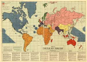
This map was created by Maurice Gomberg in 1941 to predict a “New World Moral Order” after the conclusion of World War II. This map is broken up into two parts: the visual and the written. The visual component of the map illustrates the breakdown of the new world powers in the new world order their influences on the territories that they patrol and protect. The written part is a detailed breakdown of the rules established under this new world order and the actual governing bodies that would possess all of the real power. The written part, broken down into 41 points, essentially acts as a constitution for the world. The written part shows the United States’, U.S.S.R’s, and British Commonwealth’s place and relationships in the world. In addition, the map sets up international law under the “World League of Nationalities” which is a much more powerful form of the United Nations. It also creates “Demilitarized Independent Republics” which do not have armies and are therefore less powerful then the United States, U.S.S.R, and the British Commonwealth. Some of the later points in the constitution detail punishment for the parties responsible in the war, which places Germany, Italy, and Japan in quarantine zones. This punishment includes the expulsion of people of these ethnicities from other nations as well as areas captured by axis powers, such as the Rhineland, who could cause problems if not put into isolation. The quarantine zones would be used to shape the people within them into eventual transition back into “The Family of Nations”. In particular, point 29 shows how the World League of Nations” oversees repartitions and education of the people inside these zones. To prevent another catastrophe, industry and economy has been nationalized so that the new government can control all aspects of society. Gomberg seems to indicate that if this new “Order” is put into place the problems of Nationalism and colonialism that were seen during World War II would not occur.
One of the most important parts of the analysis that showed in our presentation was the rhetorical critique of the map. We showed how the United States’ blue swaths of color in the Pacific Ocean are larger than necessary which influences the perception of the reader. Secondly, FDR’s quote in the lower left which describes a new moral order points toward the validity of the map and its author.
In the class discussion, we discussed the aspects of the map that related to our readings and the rhetoric behind maps. We discussed how the Ural Mountains and the Burma road were specifically included and not silenced like many other features. It was brought up that the Burma road was quite important in the Sino-Japanese War as a supply line. We looked at the possible motives behind placing this road and mountain range there. For instance, we discussed how the Ural Mountains acted as an indicator of the creeping advancement of the U.S.S.R into Western Europe, possibly showing Gomberg’s opinion on communist advancements. Finally, we discussed the aspects that Gomberg got right and wrong in the post war era. The students discussed how he got the influence of the major nations correct, but incorrectly predicted the power of an international governing body and necessity of demilitarized zones worldwide.
Reference:
Gomberg, Maurice. “Outline of the Post-War New World Order Map.” Philadelphia, 1942.

