

After reading the 2003 article by Elliot A. Norse titled “Marine Reserves: the best option for our oceans?” and the partially opposing views of Peter Kareiva, I decided to research more on this subject of Marine Protected Areas. The timeline we created in lab stopped around the year 2003 but this topic appears to still be of high interest among the scientific community. Upon searching the web, I found NOAA’s National Marine Protected Areas Center main page to be particularly useful. To learn more about MPAs and how you can get involved, check out the links below!
About MPAs:

Ways to Get Involved!

Each day, the website displays a different headline story to inform everyone about this growing concern. For example, today the topic of “Preserving our Maritime Heritage” is featured, with related sub-news articles about Cultural Heritage MPAs listed below and other articles listed to the right.
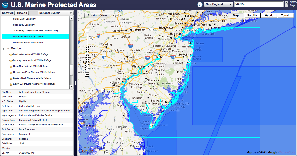
The main story featured yesterday was about the MPA Interactive Mapping Tool, which I found really unique and entertaining. Before you actually arrive to the map, they present details on the history, metadata, uses, help with the different tools, and contact information. This online mapping tool provides data for over 1,600 MPAs across the world, offering access to spatial boundaries, conservation based classification data, and about the site management. All of this information can be obtained at any time during your visit on the map by clicking on the small, round icon labeled with a letter “i” on the top menu bar.

To operate the tool based on a specific subject matter, you can either click the drop-down menu in the box on the left and choose one of the following options: National System, Level of Protection, Government Level, Fishing Restrictions, or Management Agency. For example, one can investigate what level of protection different MPAs are currently classified (No Access, No Impact, No Take, To Be Determined, Uniform Multiple Use, Zoned Multiple Use, or Zoned w/No Take Areas).
 An additional option for operating this tool is to search the MPAs by particular regions. A drop down list is located on the top right-hand corner of the screen where the following selections are available: All Regions, New England, Mid Atlantic, SE Coast, Gulf Coast, Caribbean, Great Lakes, Pacific NW, California, Alaska, Hawaii, or the Pacific Islands. For example, Virginia is displayed under the Mid-Atlantic region.
I really recommend taking at least 5-10 minutes playing around with this awesome new tool and the MPA websites, as they are extremely informative and offer constantly updated information about this question of MPAs that we previously addressed during the class discussion.
Suggestion: check out the MPAs near the coast of your home state! Here is the site from New Jersey’s coast and information about it: “Waters off New Jersey Closure”
I think that this site is really fascinating. I especially liked that the website posted a new headline story everyday. I think that that will keep people informed on many different issues. I also thought that the interactive mapping tool was awesome. You could look at any MPA that you wanted and receive tons of data. I did not know that there were different labels for MPAs and I did not know that there were so many MPAs. Overall I thought that this site was very informative and fun!
I really enjoyed this article and find the site very interesting. The interactive MPA mapping tool was really fun to use. I liked how it showed the wildlife refuges that were located on the coasts throughout the US as well as the areas where there were fisheries closures. After doing a lot of research for another class on bycatch, I found it really interesting that it also locates areas where certain types of fishing gear are used, as the type of gear usually determines the amounts of bycatch being caught. It also helps that many of the marine protected areas are labelled by the type of animal certain preserves are protecting. Overall, I think that the interactive tool is really informative because it shows how many different types of protected areas exist for marine habitats.