
Emilie Mannino
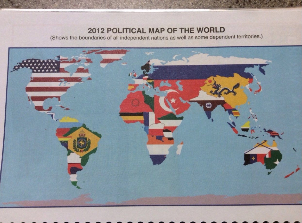
This 2012 political map was chosen as my “Map of the Week” since the cartographer shows an absurd amount of bias, along with some humor to engage the audience in an interesting way. The absurd exaggeration the map has to offer pulls the audience in with humor as the audience knows that the world map is not actually designed this way. The map depicts all the powerful and wealthy countries, leaving out the ones with a low population number and may not be as technologically advanced. This may be because the map is designed to reach a certain audience; where someone in power may be looking at specific countries to favor, depending on the world’s relationship status, audience, and technological advancements.
How could we interpret the over exaggeration of the map in terms of how large each country is shown? We can see how each country on this map is represented differently, where some countries have more or less land than the realistic amount. In simpler terms, when looking at the map, America is emphasized as much more significant than it truly is, overtaking all of North America. Ironically, the American flag represents North America; however, Mexico and Canada are nowhere to be found. Additionally, even though Europe is split up more, Turkey is heavily dense and inaccurate within a modern-day map, and France is nonexistent.
This map’s skewed perception of the landmass diverts the resources away from smaller countries with equal or even greater economic potential. The bias in how land is depicted in this map has the potential to influence the economic and social dynamics on a global scale, which may belittle certain countries that are shown. Larger countries are frequently considered more powerful and influential, while smaller countries may be overlooked, contributing to the perpetuation of regional biases; these factors may affect trade agreements and political alliances within certain countries.
Denis Wood and Susan Schulten frequently agree on whether specific maps are “correct”. Throughout each of their books and opinions, the researchers study old maps to understand the complex connections between culture, society, and cartography. Schulten and Wood’s research is known for their critical cartography, investigating maps of their perception and power. Their research and values relate to my map of the week because of a mixture of the complexity of their sarcasm, connections and power. There would be a variety of pros and cons within Denis and Susan’s opinions on this map, such as the over exaggeration of the countries, and how inaccurate the map is shown to be.
A number of the maps we study in class have different points of view that each cartographer wants to achieve. Whether it be certain types of bias or an audience they want to reach, there is always a more profound meaning within it. Looking at this 2012 political map, with no background information, one could assume that there is a direct audience that this map is aimed toward. There is a bias, and this cartographer is possibly from a first-world country.
Great work Emilie! I agree with your statement regarding the bias of this map. It is clear that countries with higher global status are given more attention in regards to their size on the map. Even more so, the iconography and use of countries flags asserts the dominance of certain countries over others. Such as how you noted the widespread domination of America’s flag over Mexico and Canada. This goes to show the economic and societal impact America has had on those countries and in a lot of ways is accredited for their success. Many lesser known or less influential countries are not given the recognition they deserve on this map, as you pointed out, which I agree goes to show the regional bias this map exhibits. I think Denis Wood would want to know about the motives behind this map. How does displaying only major countries on a map impact the economic and social status of the countries left behind. It would also be interesting to look further into the economic status of these countries when the map was produced and how it would compare if a map like this were produced today. Would the dominating countries be different or the same? I think this map is a good example of the ideas we have talked about in class this semester regarding the dangers and influence of circulating a bias map.
Nice job Emilie! Your post provides a thoughtful and insightful examination of the 2012 political map, highlighting its absurd exaggerations and bias. Your observation of how the map disproportionately represents powerful and wealthy countries, omitting those with lower populations or less technological advancement, adds depth to the interpretation. The way you go into the impact of the map’s distortion on global economic and social dynamics is particularly noteworthy. Your exploration of how the perception of landmass could divert resources from smaller countries with significant economic potential sheds light on the potential real-world consequences of such bias. Connecting this to Denis Wood and Susan Schulten’s work on critical cartography adds dimension to your analysis, and showcases a strong understanding of the context. Your last paragraph about the dangers and influence of biased maps resonates well with class discussions and further emphasizes the importance of critically examining cartographic representations.
It’s obvious that this map is extremely biased. Such designs have huge economic implications. The decision-making of many countries will be affected to some extent by this map. Objectively speaking, the bias brought about by this mapping strategy of only considering countries with large influence and ignoring small countries clearly shows the design intentions of the mapmakers and the world economic pattern they want to convey. Very good example of a bias map.