
When looking at the mystical creatures in the map above, we get a striking feeling of déjà-vu. We have all seen a map like this in one of the fantasy books we read as children. But this map is indeed a real map.
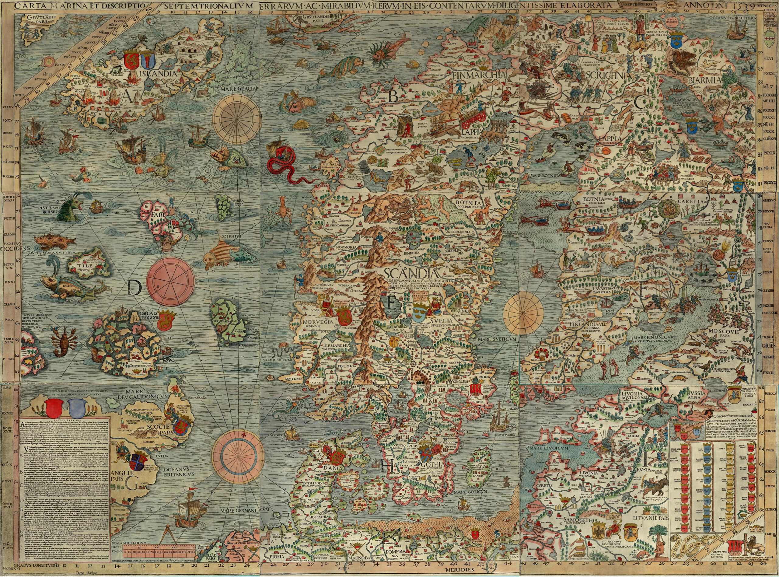
The Carta Marina et Descriptio Septemtrionalium Terrarum (Latin for Marine Map and Description of the Northern Islands) is one of the earliest maps to depict Scandinavia: it is the third map to portray the Nordic countries, and it is the first to give details about place names. The map was drawn by Swedish Catholic Ecclesiastic Olaus Magnus (1490-1557) between 1527 and 1539 while he was exiled in Rome, and was published in Venice. It is believed that Olaus arrived in Italy on a diplomatic mission on behalf of the Lutheran King Gustav I of Sweden, but stayed on because of his brother Johannes’s religious feud with Swedish authorities. Due to their Catholic attachments, both Olaus and Johannes were banished by the reformed Church of Sweden and later enjoyed successful careers in Italy.
The Carta Marina is a large-scale map that measures 5.5 feet by 7.5 feet, and that is divided into 9 parts ranging from A to I from left to right. It uses latitudes and longitudes to measure distances, and its perimap contains lines of longitudes and latitudes, the title of the map, what appears to be a family tree, and a passage of text. It is an intriguing and meticulous historical, geographical piece of art: it is precise. It provides a vivid and detailed portrayal of Northern Europe, especially the Scandinavian region. It includes detailed coastlines; depiction of cities; towns and villages; accurate place name;, mountains and rivers. During this era, the Carta Marina served as a valuable reference for sailors and travelers especially as the region started gaining increased interest due to the Scandinavian countries’ strategic location and natural resources: in the 16th century, the Nordic countries were home to a number of important trade routes, and they also possessed valuable natural resources such as timber, iron, and copper.
The Carta Marina was made at the beginning of the Age of Discovery, when a residual belief in fantastic beings such as unicorns and hybrid human-animal races such as mermaids, still persisted in the European imagination. As a result, the map abounds with imaginary sea characters such as the Kraken which was said to be so large that it could wrap its tentacles around entire ships; giant sea serpents that were a common feature of medieval and Renaissance maps and who were thought to be the largest creature on Earth; and sea monsters that were thought to inhabit the uncharted and undiscovered waters of the world, and were used to represent dangers. The inclusion of sea monsters and mythical creatures shows that much of the world’s phenomena weren’t discovered or explained yet. But that is not all. The map also shows a variety of marine activities, commercial traffic, fishing, the measuring of water depth, boats in distress, a fisherman casting his net, a sea monster attacking a ship, a group of sailors singing and dancing, and a historical battle scene, which is unusual for the time. It is believed that Olaus Magnus likely included those elements in the map to promote Scandinavia as a maritime power and assert Scandinavian sovereignty over the Arctic Sea.
In his map, Olaus Magnus included depictions of indigenous people of the North. This cultural insight is extremely valuable as it offers us and people far from Scandinavia in that period a window into their customs and ways of life: their dressing, their dwelling – in tents, huts, … -, their subsistence habits – hunting, fishing, … -, their religious habits. He also, as a Catholic Ecclesiastic, incorporated religious elements into the Carta Marina. We can observe depictions of saints and churches, reflecting the importance of the Church in the context of the time. Some other religious ideas were related to the presence of sea monsters in the sea: the scary creatures were also used to show that every being, no matter how imperfect, was a creation of God and played a role in the providential order. These ideas helped maintain a balance in the world and in the larger cosmos.
I chose this map for my post because, on top of its unmatched precision, the Carta Marina map is an interdisciplinary map that bridges history, geography, art, culture, cartology – the creation of carts and maps – and religion. The Carta Marina is also a fascinating reminder of the power maps have to tell stories that transcend time and place. The Carta Marina speaks to the universal human experience of exploration and discovery. It is a map that not only depicts the physical landscape of Scandinavia but also the cultural and intellectual landscape of people who lived there. The map is a testament to the power of maps to transport us to different worlds and different times.
The Carta Marina will remain a chef d’œuvre of Renaissance and Medieval cartography and an amalgamation of geology, art, and sociology: it serves as a testimony to the spirit of exploration that defined the 16th century, and the innate sense of curiosity in human beings.
Citations:
Nordström, Tore. Olaus Magnus: Gothus Archipiscopus Upsaliensis. Samfundet Pro Fide et Christianismo, 1993.
Larsson, Lars-Olof. “Olaus Magnus och hans karta”. Atlantis, Vol. 50, 1978, pp. 8-78.
Larsson, Lars-Olof. “Olaus Magnus och hans karta”. Atlantis, Vol. 50, 1978, p. 63.
Map link:
https://www.oldmapsonline.org/
Atlas link:
https://historicmapworks.com/Browse/Maps/
I really enjoyed reading your blog post here, as the map you’ve chosen to discuss is a very creative one with a lot of background and content to talk about surrounding history, geography, culture, art. You did a great job of presenting the history behind the map, whether it is dates, location, context, creators, size. I’m a huge fan of history, and with that I can say I really enjoyed reading your first 2-3 paragraphs where you talk about the context of the piece (the creator and how he was exiled in Rome, how him and his brother were banished and moved to Italy etc). Furthermore, a great part of your writing is where you discuss the lifestyle depicted on the piece of the indigenous people of the North, specifically the religious side of it, with all the Saint and churches painted on this large map, as religion was the grandest of prospects at that time. Something I find really interesting on this map is its incredible detail, whether that is the simplicity of the color and illustration, or even the perception of landscape and terrace of the Scandanavian land on the map. Overall, I really enjoyed this reading!
Fantastic map choice! This is so unique and interesting! I really liked how you went over the history of what the map shows and then the details of the map itself. This map is an intriguing combination of facts and human beliefs. It’s the whole idea of how human biases can impact the production of a map, this one is less bias and more how human thought can collide with fact from the incorporation of mythical creatures within the map. I also think it is interesting how this map was intended for the purpose of traveling and trade, whereas today most people would see it as a more satirical map based on the creatures and pictures. I liked your point on how the map might have been used to prompt Scandinavian power as well, it reminds me of the North Carolina State Map that we went over earlier in class and how it was used to promote the state along with being a means for traveling assistance. Overall, great job!
I also really enjoyed reading about this map as I find learning about how people of the past saw the world spatially to be quite interesting and fun. For this map, seeing that Europeans in the 16th century were able to gather enough spatial information to get a fairly accurate shape, but also include lots of sea monsters and mythical creatures in the map is interesting as it represents this transition stage in how people saw Europe in history. As you said in the paper, the imagination of fantastical creatures still exists and is present rhetorically as fact by the authors, but I also found it interesting how the map makers put in details about past cultures alongside these mythical creatures. I found it very interesting how these cultures and arts depicted on the map must have also been through a Catholic bias and how the importance of Catholicism is stated throughout the map. Finally, I found the historical description, depiction of how the map was psychically, and how the map was used to be interesting as it shows how this larger map was meant to be used for navigation, but still depicted many fantastical things. Overall, I thought you did a very good job with choosing and analyzing this map!