
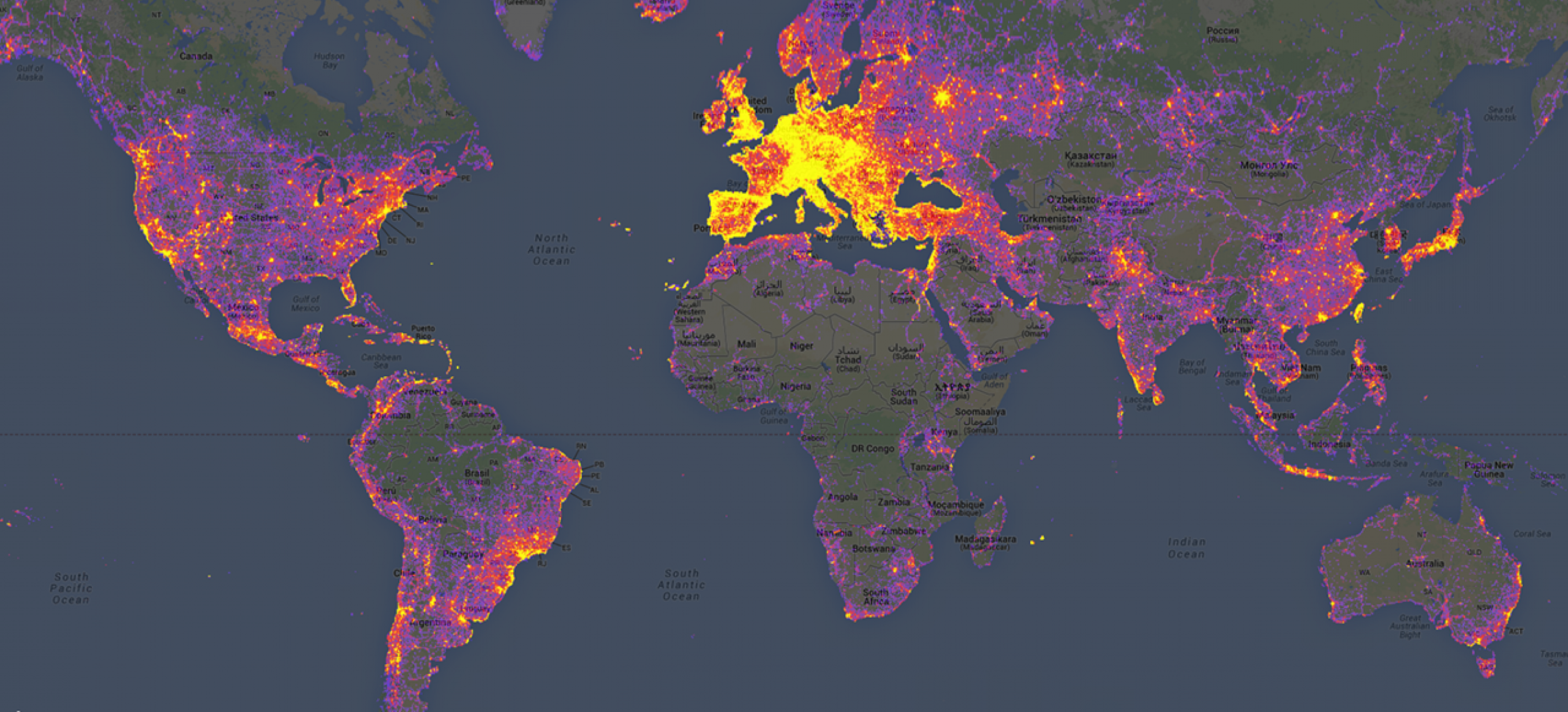
Ever wonder why everyone wants to go to Greece or Italy for summer vacation? Or even to Austria or Switzerland for a skiing trip? The answer is simple: it’s really beautiful. Cities in Europe are built around the natural landscapes of the Earth, while also keeping a touch of each countries’ ancient architecture, giving it a much different feel from the modern day cities and skyscrapers and perfectly built roads we are used to here in the US. The map above is a depiction of the most photographed places in the world. It is evident that, by the collected data, Europe is the most photographed region in the world by a margin, specifically Western Europe. From landscapes with tall mountains, bright green forests, lakes and rivers, to cities with modern architecture, classic cars on heavily trafficked roads, Europe has a lot of places that are photograph worthy that we see in our everyday magazines, or, nowadays, our Instagram Explore page. By looking at the map, we can tell that the most photographed country in the world is Italy. The heaviest density of gold color lies in the region where the Alps range. Countries such as Germany, Switzerland, Belgium, Austria also have high data on this map. Moscow is an outlier of Northeastern Europe, being just a single spot of heavy photography. Eastern China and Japan are two of the very few heavily-photographed locations around their proximity. In the United States, New York City, Florida, and California are the top three, and rightfully so. The sharing of these photos of these places throughout the mainstream media through the internet had me, as a European myself, only knowing these three locations from the whole country of the USA.
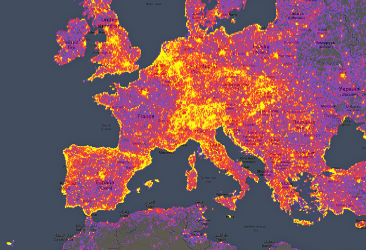
Being from Greece, half of my camera roll is scenery of the country, from ancient Greek landmarks, to the most beautiful beaches in the world. Greece is up there with the most photographed countries in Europe, with most of the “golden” areas laying on the coastal parts of the countries, highlighting the beaches and oceanic skyline. Whenever I’m back home, which is usually during the summer, I notice tourists spend more time taking photos of the beach rather than actually swim or suntan. They spend more time looking at the Acropolis through their phone screen while taking hundreds of photos without subconsciously realizing that they’re not admiring it with their own eyes. Even in restaurants, they’ll take a picture of their Greek salad and their Moussaka before they eat it. Got to have the moment filed in their phone, better not forget to take a photo! I’m 100% certain that this is evident in other popular European capital cities that are heavily photographed: Paris, Madrid, London, Athens, Rome, Moscow. Each countries’ signature plate or famous ancient landmark, tourists will most definitely take hundreds of pictures before departing.
Thus far, only the continents of Europe and North America have been brought into discussion; so what about the other 5 continents? The simple answer would be that they just aren’t photographed as much. Yet, what if it’s just a lack of data? What if it’s just the lack of smartphones in those dark areas that are the modern day cameras everyone uses. We can all agree that Africa is a beautiful continent made up of healthy jungles and landscapes inhabited by animals. What if this map is just another biased image trying to positively endorse European countries? Well, Europe is the most visited continent in the world (worldatlas.com). Tourists mostly visit European countries and islands, which all have their own unique characteristics of natural landscape, cuisine, architecture, that is not seen anywhere else in the world. It’s a subconscious motive to take pictures of these things, and I’m speaking from personal experience seeing how tourists operate when they visit my home country. Additionally, not everyone has the opportunity to make such a big trip to European countries, so they look for all these photos online, which are all shared heavily, which increases this data even more.
Works Cited:
Lalueta, Inés. “Holidays vs. Mapping the World’s Most Photographed Locations.” Holidays vs. Mapping the World’s Most Photographed Locations | The Strength of Architecture | From 1998, www.metalocus.es/en/news/holidays-vs-mapping-worlds-most-photographed-locations
Blog Link: https://twitter.com/Amazing_Maps
This Twitter/X page posts maps focused either on the US and specific states, or can show data from the whole world. The maps posted provide really random yet interesting data and information that may not really help us in our life, but can entertain us to some degree.
Atlas of the Week: https://storymaps.arcgis.com/stories/0a56aa3a277741bc9c6825880103d465
This page talks about the growth of “green life” within urban cities and counties in the US during the constant population growth. This page provides a lot of data about population growth over the years, its pros (economic development) and cons (pollution, energy consumption), and how urban trees can improve these cons. It later has an interactive map about the amount of trees in counties over the years. A really interesting and well thought out presentation about a problem of todays world.