
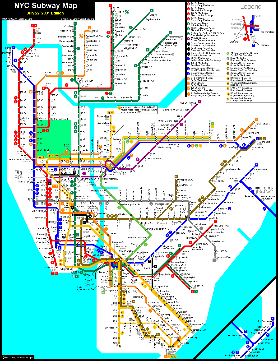
Links to higher quality maps: https://www.nycsubway.org/perl/show?/img/maps/calcagno-2001-07-22.gif
https://transitmap.net/post-911-subway/
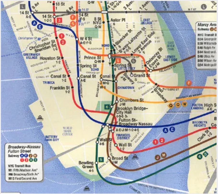
In large metropolises like New York City, transportation infrastructure is crucial to the function of the city. Public transportation such as metro lines, bus routes, and taxis along with road infrastructure like interstate highways and bridges can make or break the economic success of the city. As a result, when loss of function of these systems occurs, cities attempt to resume service as quickly as possible. This map looks at a comparison of New York City’s subway service and general public transportation systems before and after the terrorist attacks of September 11, 2001. The first map provides background information on the New York City subway system before the attacks, around July 2001, and the second map was released six days after the attacks, on September 17th, 2001, showing the altered service around the lower Manhattan area as a result of the attacks. This post also includes information gathered from a report on the effects of catastrophic events on transportation operations done by the USDOT.
The attack began during the morning rush hour on Tuesday, with the first plane flying into the north tower at 8:46 AM. According to the report on the effects of catastrophic events on transportation operations done by the USDOT, one minute later, the MTA Subway Control Center was aware of an explosion at the WTC and began emergency protocol. Within the next few minutes, both the NYC Transit and NJTransit were aware of the situation and began to evacuate the area using both the subway and the NJ PATH trains. Less than 30 minutes after the first impact, the port authority closed all bridges and tunnels into New York City. Airports in the metro area were grounded soon after due to an order from the Federal Aviation Administration. After the south tower collapsed at 10 AM, the MTA suspended all subway service in the entire city. At this point in the late morning, New York City had ground to a halt. Bridges were closed, the city was gridlocked, and no public transportation was available to commuters. People were getting out of their cars and walking to their destinations, and if they didn’t have anywhere to go, they just walked north, away from downtown Manhattan, and away from the dust cloud that had risen from the collapsed towers. Lower Manhattan’s subway infrastructure had been completely crippled. The World Trade Center station at Cortlandt Street had fully collapsed, cutting off the rest of the 1-9 subway train down to South Ferry near Battery Park. Stations on the A train had also been damaged. Despite the complete shutdown on the island of Manhattan, NYC Transit got to work. By 1 PM, partial subway service had resumed throughout the city, with many trains avoiding lower Manhattan or diverting their routes. By nightfall, two-thirds of the NYC subway systems except those in lower Manhattan had resumed and were beginning to function as normal. In the following days, Manhattan’s public transportation system started the return to normalcy, almost impossible to think about considering what had happened. The second map shown in this blog post was released six days after the attacks, showing how service in lower Manhattan was affected. The 3 train became a de-facto Manhattan shuttle, and the 1 train replaced the 3 train with service into Brooklyn. The E train stopped its service into its World Trade Center station and bypassed that branch of track while repairs commenced. Bit by bit, lower Manhattan repaired and healed from the attack, and more services started to come online towards the end of 2001 and into 2002. Almost a year after the infamous day, NYC transit resumed its service to South Ferry and the World Trade Center on September 8th, 2002. The US Department of Transportation’s report on the response to the catastrophic events of 9/11 found that transportation officials had been prepared well for some level of system failure, but not at this scale. Even though, officials handled the events well and kept the safety of rescue workers and civilians at the highest priority.
Maps are essential partners to transportation systems around the world. You wouldn’t just hop on a bus or a train without checking a map to make sure you know where it’s going first. As a result, it is imperative that maps of public transportation accurately represent the systems they depict. We take their effectiveness for granted, but a lot of work goes into designing transportation maps to ensure they are accurate, simple, and easily understood by the general public. When events happen that hinder or change the way the systems work, the new maps that are produced quickly become a medium through which the public can adapt to these new changes.
These maps show the resilience and strength of the New York City community and government as they worked to overcome the greatest challenge the city has ever faced. The New York City subway map changed nine times between the attacks and when the system was finally repaired a year later. Not only does this represent the physical change the city underwent in the rebuilding process, but it also is a metaphor for the healing process – healing takes time- it doesn’t happen overnight. As we all know, maps are not permanent. As the real world changes, the symbols and designs that represent it on a map also change. The life of the New York City subway map went through many changes during the early 2000s, but it never stopped serving its purpose.