
The Piri Reis
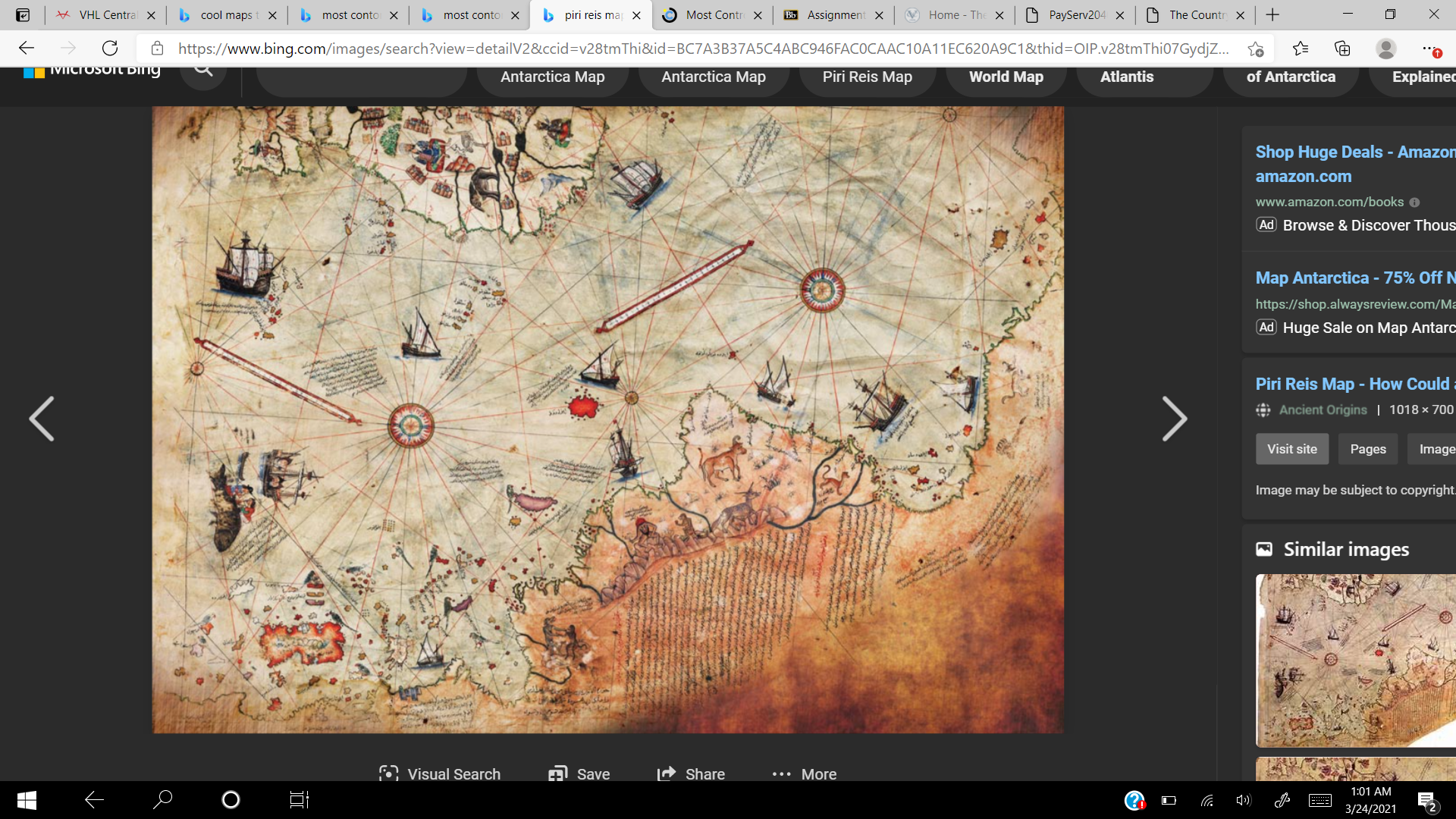
When people talk about controversy regarding maps, there is no conversation that is able to be had without bringing up the map, the Piri Reis. This map has been around since the age of great geographical discoveries, from the 15th to 17th century and was created in 1513. Some researchers that have studied this map see it as evidence on old research of the Antarctic coast before the era of Great Geographical Discoveries. This leads to much controversy and different theories about this map since there is no actual evidence supporting the claim by these researchers. This map has caused much commotion since the moment it was discovered, (Tchakarov pg. 1).
A German theologian by the name of Gustav Adolf was the man who discovered it on October 9,1929. He was hired by the Turkish Ministry of Education to catalog different works and findings. When he discovered the map, he realized that he could be holding a unique and important piece, and gave it to an orientalist named Paul Calais, who identified the map as Piri Reis. After that, this map became a sensation because it was the only known map of the world that was “discovered by Christopher Columbus”. As we now know this is untrue, but at the time this is the land that they thought Columbus had gone to. Also, it was the only map to that date that showed South America in its correct longitudinal position to Africa. What they found was only a fragment of the entire map, and due to the damage, some of the dimensions are fragmented, but some numbers were able to be seen, so they were able to interpret it, (Tchakarov pg.1). In the legend of the map, it is said that using twenty graphics, and mappae mundi, which is the maps of the world, Piri Reis assembled this map. These maps included eight Ptolemaic maps, an Arabic map of India, four newly drawn Portuguese maps of Sindh, Pakistan, and a map of the lands that Christopher Columbus had supposedly discovered. This map is currently being kept in the library of Topkapi Palace in Istanbul but is not often shown to the public.
The biggest controversy and overall confusion regarding this map is the fact that it could possibly depict Antarctica 300 years before the southern polar continent was discovered, (Tchakarov pg 2.). The other, even more outlandish statement is that Antarctica is shown as it was before it was covered with an ice cap, which was more than 6,000 years ago, (Ancient Code pg. 2). There are several anomalies that do not match the timeline that this map would have been created. One of them is that it uses the Mercator projection. The Mercator projection is a cylindrical map projection that shows north as up and sound as down while preserving local directions and shapes. While this projection was created in the mid 1500’s, since this map was drawn and signed in 1513, it causes confusion due to this projection being used over 50 years before its alleged creation. The other large anomaly is the inclusion of Antarctica without its ice cap. Studies done by a college professor, Charles Hapgood, and his class from New Hampshire College concluded that to have this kind of depiction and description, this map would have had to have been based on sources from 4,000 BCE. What is more is that to have this kind of topographic representation of the area inland of the coast, one would have had to have aerial capabilities in addition to normal abilities, which is unheard of at a time so long before any sort of realization into airborne capabilities,(Tchakarov pg 3). There is still no proof proving or disproving that the Piri Reis map shows Antarctica or not. If people believe it is Antarctica, then it is conceivable that some ancient civilization must have had advanced navigational skills that would be centuries ahead of their time. The other more sensible idea is that it is a depiction of the lower coast of South America, which is the more probable idea, but no one knows for sure yet. However, either way, with the use of the Mercator projection years in advance of its “founding” and the orientation of this map cause it to be unique and one of the most talked about maps from the great discovery This map presents a lot of historical context that calls into question a lot of different events from the past, but the one thing that comes to my mind when looking at the background and description of this map is that it can show that even though advancement in maps and technology happens with time and more and more progress, this map can show there were people or there were maps that can show this advancement much before the time it was told to have happened. Especially like the Mercator projection and how this map used it almost half a century before it was so-called created, it is interesting to see how no matter what the era, or where in the world, there can always be new findings and new developments in the making of maps.
This map also calls into question the ideas of politics a bit with the usage of Christopher Columbus in this map. As we all know now, Columbus landed in North America and called it the New World. But back then people thought he landed in the West Indies and and the places that are regarded too in this map. So, when people looked at this map and defined some of these places as the land discovered from Christopher Columbus, it could cause some political controversy because many may not like that in the present. Especially with some of the backlash that Columbus is getting in the United States now due to what he did to the natives already living in the New World, some may take offense to being called the land that Columbus discovered like these lands are called in this map. It just shows that there is always a political and historical side to each map that is created, especially ones that stem as far back as the Piri Reis.
Citations
Tchakarov, Vladislav. Most Controversial Map in History; What Secrets Does the Piri Reis Map Hold? 3 Nov. 2020, curiosmos.com/most-controversial-map-in-history-what-secrets-does-the-piri-reis-map-hold/.
Team, Ancient Code. “Before Antarctica Was Covered in Ice-Someone Mapped It with Extreme Precision.” Ancient Code, 27 Feb. 2018, www.ancient-code.com/antarctica-covered-ice-someone-mapped-extreme-precision/.
This map is super interesting to me because I’ve never seen it before. I like all the historical context you gave surrounding the time period in which the map was made. I was most interested in how the map could possibly depict Antarctica 300 years before people agree that it was discovered. This makes me wonder if maybe the time that historians generally agree that it was discovered is wrong. Even more so than that is the idea that it was depicted without its ice caps, even though that would have been thousands of years before the map was made. I think you explained some of the anomalies and unique parts of this map very well.
I absolutely love this type of History and Mapping. The mystery surrounding this map add to the intrigue immensely. I think that you expertly delved into the map’s inner-workings and discovered truly interesting things. You also did a great job of leading me, as a reader, on a rollercoaster of mystery. I also think this is great choice of map because the maps we have studied in class have almost always been a definite not an unknown. I think this unsureness adds to the era in which the map was made and the character of the map.
Great job with this find! What an interesting find considering the age and unknown origin. I found the Historical context, or lack of, in its origin fascinating. I am left with many questions that you touched on. How did they have such great knowledge of the coastline? Why was Antarctica depicted as being lush and green and how would they have info about the continent that is from 4000 BCE? Finally, where are the other pieces of the map, and how did they know the Mercator projection. It is clear to see why this map is used in many controversial conspiracy theories but I’m cautious to say whether it’s advanced tech or dumb luck, or maybe a combination of the two! It doesn’t help that they don’t display the map publicly that probable fuels the chatter around the mystery. I’m also intrigued on how it was rediscovered. Maybe we will uncover more of it in the future? So much to talk about with this map. I’m glad you brought this map up for discussion and I’m sure it will keeping turning heads for years to come. So much of the past, the people, and the society which commissioned this map can be seen in it. How they viewed the world and their place in it. One can hope that more of it will show up!