
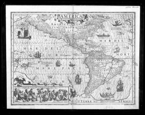
My choice for the map of the week is the “Map of the Western Hemisphere” from the Mercator-Hondius Atlas published all the way back in 1606. Hence the name, the atlas includes work from Gerard Mercator and Jodocus Hondius. Living in Europe at the turn of the seventeenth century makes it hard to accurately map the western hemisphere due to the lack of full exploration and knowledge of the land. Despite this, Mercator and Hondius were up for the challenge of creating a map that resembles the general shape of what we know as North and South America. Unfortunately, Mercator died in 1594, during the atlas’s creation, which forced Hondius to complete most of the map. Although it still uses a Mercator projection, the map is credited as Hondius’s work.
The significance of the map being published in 1606 is important because of the events that took place shortly after. The following year in 1607 Jamestown, the first English settlement in the Americas was established. This marked the beginning of European settlers permanently living on this land. The map serves as a foundation for what was known about the land to the people that were now living there. Although the continents are shaped differently than how we see them on maps today, the general shape is close enough to the point where we know what is being mapped. Certain landmarks can be seen that are still known today such as the Gulf of Mexico, Baja California, and the Caribbean. Also, California, Patagonia, Brazil, and Cuba, among others, are all names that can be found in the same spots we see now over 400 later. These names have been around for many years leading up to the time they were mapped by Hondius despite no Europeans living there. The indigenous people living in the Americas already had locations mapped and named in the region. The European explorers took this knowledge and claimed it as their own. This was the first step in the colonization of the region; first, they took the information, then the land.
The bottom left corner features an illustration of the indigenous people from South America. The image depicts women cooking food while the men are eating. Based on the clothing and pottery it seems that the map makers had accurate information on who lived there. Due to the size of the region, I believe that these people were the ones that helped give the explorers the information they needed for all of the names and topography we see on the map. There is too much on the map for it to have been made without outside help. Another piece of information that I’m surprised about the map was the known topography of the area. The centers of the landmasses are much more empty when compared to the coasts but still have mountains and rivers. Since boats can only reach the coasts, that information cannot be mapped by explorers, and anything more inland had to be indigenous information. Although it is not hard the map coastal mountains, all mountains and rivers are clearly labeled and follow a very similar direction to the way we know them today. Before they officially settled on the land, explorers encountered the indigenous people and used their knowledge to gain an understanding of the area.
In addition to the people, the map also includes fish and ships, a British delicacy… or is it fish and chips? Anyway, scattered throughout the ocean are fictional sea creators and large explorers’ ships. For me, these both express the idea that although the land has been “discovered” there is more that is unknown. The Spanish Empire claimed that they found America despite the fact that they used information from people already living there. They felt they had the right to claim it solely based on the power they had. The ships scattered throughout the map show that they are still attempting to understanding what is unknown and conquer more land. Without saying it, this map shows the power of colonialism and what was going to happen in the coming decades. The fact that the map had so much detailed information despite no Europeans settling there shows the power of exploration at the time.
On the surface, this may seem like an outdated map of the western hemisphere. This makes it deserving of the map of the week because of the hidden story within the map. Knowing that the map was made before Jamestown was established shows the control that Europe had all over the world. Hondius was able to create a labeled map of a region that hadn’t been fully explored by Europe. Access to guns and ships allowed Europe to have power over less developed areas of the world. Reading into the narrative of the map changes it from a harmless “Map of the Western Hemisphere” into a map of the upcoming events of colonization that will take place. This course has allowed me to understand that maps have a narrative beyond the image it appears to show.
See Map here