
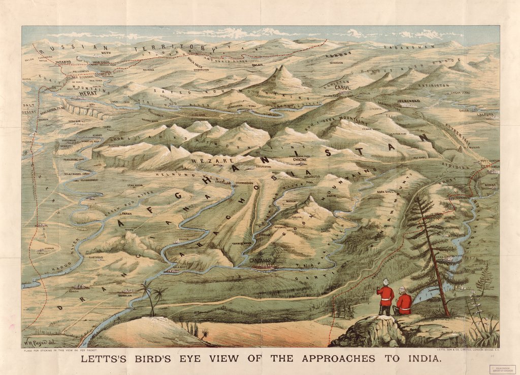
At first glance, most people would be deceived by the well-chosen color and the exquisite details of the map, and hence consider this piece as a painting. Actually, Letts’s Bird’s Eye View of the Approaches to India is a panoramic map made in Britain in 1900. It conveys the ideas of maintaining British control over her colonies and expanding the empire into Afghanistan, by applying the bird view, mapping the borders of surrounding nations, and adding artistic details.
The map looks over to Afghanistan, the border of the Russian Empire and of Persia from the northwest border of British India, present-day Pakistan. The bird’s eye view provides a good sense of the Afghani territory, where the rivers and mountains are clearly drawn and labeled. This perspective includes most of the territory of Afghanistan and extends further to the north. In the time when strong European powers spread their colonies all over the world and competed with each other, the impression of unlimited territory suggested the idea that there were infinite land and resources beyond India, waiting for Great Britain to obtain. Borders are represented by red dotted lines. The bright color makes the borders more obvious. Moreover, mapping out the border of the Russian Empire reduces the distance between the two great powers, and hence gives a sense of competition and tension to the reader. Another little detail of the red border line is that they are labeled as British, Russian and Persian borders but not the Afghani border even though they encircle the Afghani territory. This design reveals the author’s understanding that Afghanistan was not considered as an independent nation, but rather a piece of land that can be taken over by the surrounding stronger nations. The finishing touch of the map is adding the two British soldiers in their red uniforms located in the lower right corner near the British border. The soldier on the left is pointing to Afghanistan and seems to be talking about the future, where Afghanistan becomes a new colony of Great Britain.
The political message of the map is clear due to the way that the author drew the map and the elements he added to it. He did not focus on exact geographical locations or accurate scale. Instead, he emphasized the overall structure of the territory and artistic details like using red dotted lines to represent borders and adding British soldiers. Considering its geological accuracy, artistic style and intention, this map is not geographical cartography, but more of a historical cartography that reveals political and historical information. In this sense, this map is a propaganda map that introduces the idea of colonizing Afghanistan to the readers and appeals for public support on colonial expansion.
Ironically, the results did not turn out as the British empire expected. In 1919, the Third Anglo-Afghan War ended British control over Afghanistan foreign policy. In 1947 Britain passed the Indian Independent Act and soon the Indo-Pakistan war took place. As Denis Wood claimed in his book The Power of Maps, the map is outdated the moment it is completed. It belongs to the past and can hardly foresee the future.
This is a very interesting map! It has a very unorthodox style as it looks like more of an artistic drawing rather than a map that could be used for navigation. Adding on to your analysis of the political agenda of this map, I found the title very interesting. The use of the phrase “approaches to India” makes it seem as if the British are trying to conquer some kind of foreign land. It gives them a sense of power and reveals that they want this territory for themselves. Again, nice map choice!
Anni, your map choice is an unique one. I like your analysis of the map being a historical piece of cartography and not geographic. It shows the political agenda of the great powers of the world at the time. You make this very clear when you point out Russia’s territory and explain how Afghanistan is a contested piece of land between Russia and Britain. This spotlights the imperialism of the time.
Additionally, it was important you pointed out the artistic nature of the map. This shows that the mapmaker was not concerned with the accurate portrayal of the land, but more with taking over the country of Afghanistan.
Also, I enjoyed the Dennis Wood comment at the end.