
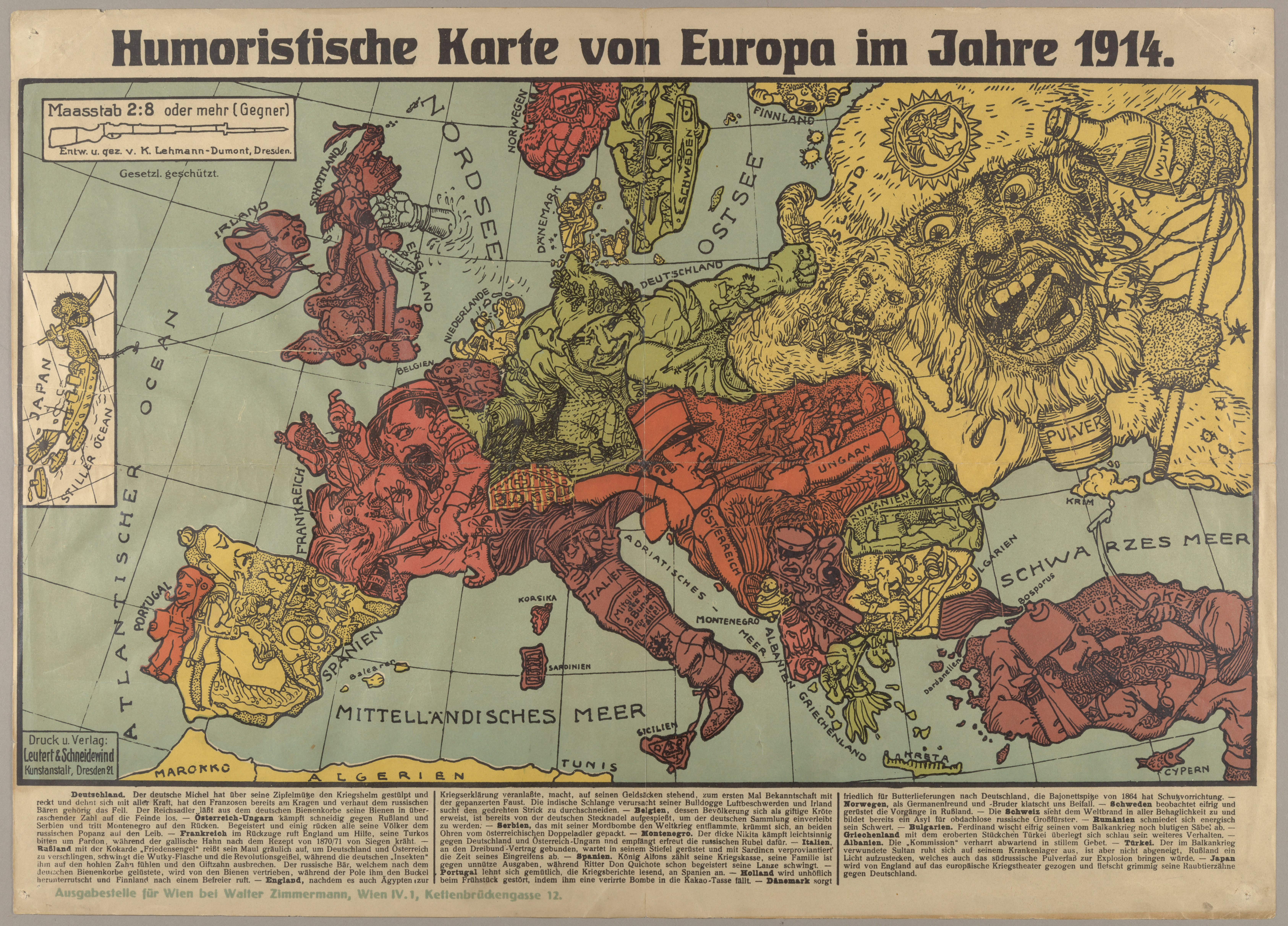
Humoristische Karte von Europa im Jahre 1914 contradicts traditional western cartography in its depiction of World War I. World War I began because of a system of entangling alliances. After the political assassination of Austrian Archduke Franz Ferdinand by Serbian political terror group, the Black Hand, Austria-Hungary declared war on Serbia one month later. This had a tremendous trickle-down effect. Austria-Hungary was a member of the Triple Alliance which included Germany and Italy. On the other hand, Russia backed Serbia in war because of their common Slavic heritage. The larger issue was Russia was a member of the Triple Entente with France and the United Kingdom. When Austria-Hungary declared war against Serbia one month later, a majority of Europe went to war. Following the outbreak of war, Humoristische Karte von Europa im Jahre 1914 served as a piece of German political propaganda that utilized caricatures to mock cultural stereotypes of their adversaries.
The overwhelming feature of Humoristische Karte von Europa im Jahre 1914 is the use of caricatures. Before the 20th century, caricatures were predominately used to satirize a subject, often politics or cartoons. Humoristische Karte von Europa im Jahre 1914 takes a different approach. Caricatures are utilized as political propaganda. Caricatures are a hallmark of political propaganda and reduce geographic areas to stereotypical characteristics based on ethnic or national identities. Reducing nations to human faces is anthropomorphism. On one hand caricatures simplify global war, but instead distort and exaggerate ethnic composition. An example in Humoristische Karte von Europa im Jahre 1914 is Russia’s caricature. Russia is characterized as monstrous figure with a bottle of vodka and bear. This illustration is validated by Russia being stereotyped as a society of heavy drinkers and the bear as a symbol of their empire.
Each nation is depicted with a distinct caricature that resembles their country. In comparison, the Central Powers are portrayed more favorably than the Allied nations. Considering the map is from the German perspective and current political conflict, the author intentionally drew Germany and Austria-Hungary with no derogatory stereotypes. Instead stereotypes were to applied to every other nation. For example, the United Kingdom is harshly criticized. A portion of the caricature illustrates a man standing on a pile of money while being punched by a fist of water. Embedded in this caricature is a series of codes. The piles of money the caricature is standing on is a representation of the wealth England has accumulated from being an Imperial power. However, England is punched in the face by its global colonies for dragging them into a European conflict. Both the pile of money and water fist can be viewed as signifiers. A signifier is a symbol that stands for a signified, a deeper meaning. Therefore, the pile of money symbolizes wealth and the water fist portrays angry colonial holdings which are the signified explanations of the symbols. From a propaganda perspective, the author is able to criticize the shortcomings of each country.
Humoristische Karte von Europa im Jahre 1914 is an unorthodox cartographic depiction of World War I. Standards for western cartography traditionally emphasize geographic accuracy and detail. Although, accuracy is a cartographic choice. Instead of replicating geographic terrain, the author chose to socially construct reality. He implemented his own agenda into his work. The map has a distinct red coloration. Dull and opaque shades of red are used for most of the major Allied Forces and Ottoman Empire. In comparison, the Austria-Hungary Empire is depicted in a brighter red. The author utilizes different shades of red to highlight German attitudes towards nations. Dull and opaque coloration for enemies and weak allies while a brighter red for a favorable ally. Another unique attribute is a legend situated at the bottom of the map. The legend provides the significance behind each nations caricature. At the time of publication, the legend would have been a expendable feature of the map. Any individual in Europe would have been able to view the map and understand the cultural stereotypes each caricature portrays. Viewing from a modern context, the legend is more relevant. The legend delivers a story narrative. It allows viewers to understand the cultural stereotypes that persisted throughout Europe in the early 20th century.
Overall, Humoristische Karte von Europa im Jahre 1914 takes an alternative approach to illustrating the start of World War I. Caricatures are the overwhelming feature of the map and illustrate cultural stereotypes of each nation. Code is embedded throughout the map and serves as signifiers that represent a deeper meaning, the signified. Various shades of colors are used to reflect positively or negatively on countries. A legend is positioned at the bottom of the map and provides context to the caricatures. With an unorthodox approach and appealing attributes, Humoristische Karte von Europa im Jahre 1914 is a relevant map that should continue to attract modern audiences.