
![]()
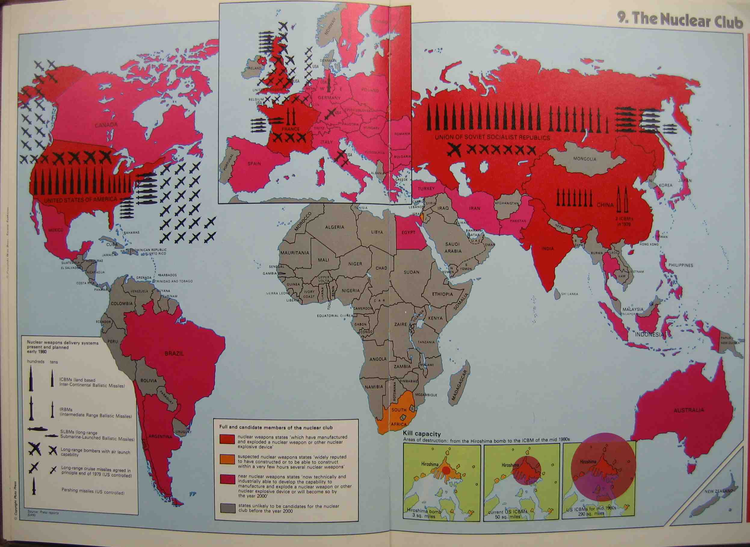
The “Nuclear Club” map was released as a part of the 1981 “State of the World Atlas” by Michael Kidron and Ronald Segal. Published by the Pluto Press – a radical leftist group based out of London – this atlas features a myriad of fanatical maps. The map doesn’t attempt to hide its strong anti-American bias, and could have possibly been designed in protest of the then-recent election of conservative Ronald Reagan to the presidency. The stiffly anti-nuclear stance taken by the Pluto Press was ridiculed at the time of publication, but grew to be the mainstream position overtime.
The map itself divides the countries of the world into those who have manufactured and exploded a nuclear weapon (i.e. members of the ‘nuclear club’), those that are able to or soon will be able to, those that are suspected to have the capacity, and those that are unlikely to before 2000. Countries that are part of the ‘nuclear club’ have their nuclear arsenals depicted in large black symbology that seems to almost comically spill over the boundaries of the states. An inset at the bottom of the map entitled “Kill Capacity” visualizes the explosive radius of the ‘Little Boy’ dropped on Hiroshima, current American ICBMs, and projected American ICBMs for the mid-1980s. Interestingly no mention of Soviet weapons is made here, despite the fact that the USSR detonated the Tsar Bomba over two decades before the publication of this map, and it remains to this day the largest explosion ever recorded. The map also places an unconventional emphasis on Europe by enlarging the continent with an inset in the dead center of the layout. This serves to only elevate European nations onto the same geopolitical stage as the U.S. and the U.S.S.R., but it also conveys the notion that any missile launched by the Americans or the Soviets would have to travel over Europe. Finally, the map’s projection of Siberia and Alaska is problematic because it artificially enlarges the space between them. The Bering Strait is made to be roughly the size of a sea and the Aleutian Islands are simply not included on the map. This strange method of depicting the spatial placement of the U.S. and U.S.S.R.’s extreme boundaries again serves to elevate Europe’s centrality in the nuclear conflict by essentially eliminating the possibility of sending missiles over the Pacific.
I thought you did a great and thorough analysis of the map considering its dense biases you had to untangle. I liked how in addition to exploring the historical context behind the map, you referenced its stylistic and iconographic choices. By talking about the various emphases of the map, you brought light to choices such as projection and geopolitical significance. I also liked the points you made about Europe, which before I believed to be completely neutral in the Cold War nuclear conflict. Overall, I thought this map was interesting and that you had a strong critique.