
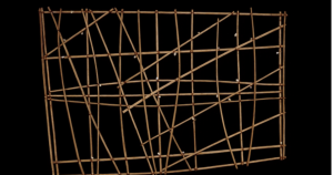
While this map may look like nothing more than a piece of modern art or a failed attempt at woodworking, it is in fact a 19th century Navigational Chart from the Marshall Islands of Micronesia. Although it is commonly referred to as a chart and its appearance may differ from that of a “normal” map, the navigational chart serves the same basic functions of all maps: to visually present information with hopes of deepening or clarifying one’s overall understanding of a topic or layout of an area.
The Marshall Islands are composed of more than one thousand islands or islets that extend over hundreds of miles. Due to the large distance between islands, Marshallese (inhabitants of the Marshall islands) had to become proficient sailors. As the Marshallese became more skilled sailors, they began to expand their routes, traveling to farther islands. With this expansion of travel and addition of routes came the need for a tool that could map out routes, this tool took the form of the Navigational Chart.
While each chart differs slightly in appearance, the majority of them are made from interwoven sticks with shell detailing, representing islands. The horizontal and vertical sticks support the structure and the diagonal sticks show wave and tide movement. The Marshallese would study the map by focusing on the locations of the shells and the positioning of the diagonal sticks, adjusting their routes as they saw fit. Unlike 21st century maps that are portable (either on your phone or collapsible paper maps) this map did not travel and would instead be studied before the voyage was made.
This map is particularly unique as its simplicity reflects both its function and the culture that created it. Unlike world maps being created during the 19th century, this map does not include any extravagant borders, fancy font, or eye catching colors. The Marshallese did not include these details, not because of their lack of sophistication or elegance, but rather because they were more focused on the functionality of the map rather than the artistry of it. The Marshallese did not need the map to be grandiose, they just needed it to show them where to go. The materials used to create the map not only add to the simple appearance but are representative of the resources that were available and important to the Marshallese culture.
Maps are out of date as soon as they are printed. Our world changes so quickly that it is impossible for a map to be perfectly up to date. In order to ensure that the navigational maps were as useful as possible, the Marshallese had to update the maps quite frequently to show new islands or a change in the tide movement. Fortunately for Marshallese cartographers, the simplicity of the maps made the updating process rather quick. If each map included extra details, like that of an extravagant border which is not necessary to its function but more for show, the maps would take longer to update and the function and reliability of the map would be sacrificed.
While this map may not be of any use to you, as you are not sailing around the Marshall Islands in the 19th century, it is important to recognize how powerful this map was and continues to be. In the 19th century, the peak of this maps power, the navigational charts aided the expansion of the Marshallese culture by providing a way to chart new discoveries and find new routes. Today, these charts are being made not as navigational tools but as souvenirs. These souvenir charts do not function like that of a 19th century navigational chart but they symbolize the power and importance of navigation charts in Marshallese culture.
We, members of the western culture, have a very specific idea of what a map should look like and how it should be used, often putting more emphasize on familiar looking maps. This navigation chart forces us to step outside of our comfort zone and acknowledge that our westernized concept of maps limits our exploration of other cultures. Looking at maps like this allow us to expandour concepts of maps and see that although different cultures produce different maps, they all have similar functions and goals. Overall, this chart, and navigational charts like it, should be admired due to their relative simplicity and immense practicality, and should be remembered because of the tremendous power it held in the Marshallese culture.
Sources:
“Marshall Islands.” Wikipedia. October 03, 2017. Accessed October 04, 2017.
“Navigation charts.” Khan Academy. Accessed October 04, 2017. https://www.khanacademy.org/humanities/ap-art-history/the-pacific/a/navigation-charts.
I also used some prior knowledge about these maps that I learned in Art History
Katherine,
This is a very interesting and fascinating choice! Yes, I thought it was an exquisite artwork at the first glance too, and it was so hard to relate it to maps. However, you gave an insight about the history and the functions of the map, which really helped me understand the significance of this map to the Marshallese culture. I also really like your critiques about the flexibility to adjust and the cultural perspective we should hold when watching this map. Nice work!
Rong