
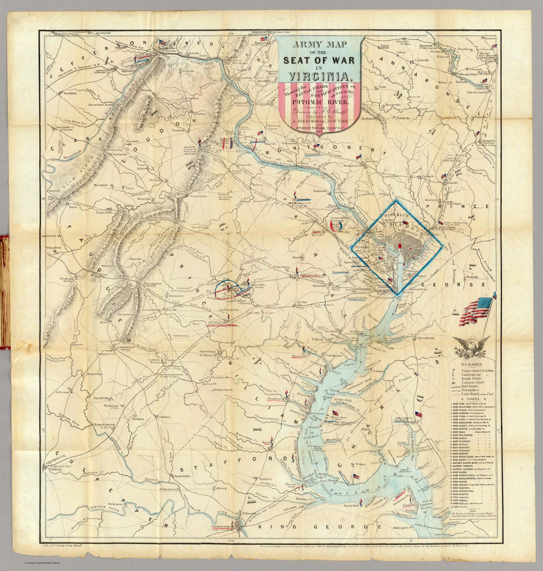
Have you ever thought of maps as a vehicle to sway opinion? What if I told you cartographers of The Civil War used maps in order to gain support for the war and boost morale? “The Army Map of the Seat of War in Virginia” was created by JG Bruff of Washington D.C. in 1862. The map portrays positions, battlefields, railroads, and a plethora of other landmarks in a detailed scientific manner. It includes major battles such as The Battle of Bull Run and also includes a list of 34 U.S. forts in the vicinity of Washington D.C. If we look carefully at Bruff’s work, we realize it is prone to having political interest beyond that of reporting the war; his map strives to influence the social and economic opinion of the public in order to favor the war. The map provides a textbook example of how maps can be used in a rhetorical context to shape the thoughts and identities of its audience.
We can begin to expect political interest to be prevalent due to the fact the map is created by a cartographer who works for the United States government as opposed to that of a neutral party. The political interests are first seen when analyzing the legend of the map. Bruff provided two different symbols for United States Positions as well as Confederate Positions. Although at first sight this small difference appears to be meaningless, if we look at the map from afar we may assume that only the United States had positions due to the proud flag blowing in the wind that represents their positions. In contrast, to mark Confederate positions the cartographer used a much smaller, less proud, dilapidated flag that is not as easily seen as that of the United States. Therefore we can infer that the cartographer chose to draw the audience’s attention to only the United State’s’ positions in order to gain support and hope for the ongoing war, which was just in its infancy. This tactic results in unity and backing for the goals of the government, which increases the government’s odds of achieving their goals.
Furthermore, the cartographer made the choice to showcase Washington, D.C., the Union capital, by encompassing it in a large blue diamond. By doing this the cartographer made Washington D.C. the center of attention, as well as, the fortifications surrounding it. The cartographer goes as far to include a note in the bottom right hand corner stating: “48 Works of Defense around Wash and The District of C. mounting 300 Guns”. We could infer this is another ploy to shape the opinion of the audience by making them believe that Washington D.C. is the mecca of the country and is well- protected against its Confederate enemies. In addition, Bruff only included a list of Union forts rather than mentioning the Confederate forts as well. Therefore Bruff portrays the Union Army to his audience as a significantly stronger force than the Confederate Army for the goal of gaining Union support for the war.
In order to help hide these political interest the cartographer employed a scientific style when drawing the map by adding a significant amount of detail. By articulating his work in this fashion the cartographer is able to convince the audience they are viewing a work of science and fact as opposed to a government made map. Most people are unaware of any rhetorical strategies due to the fact that they use maps as a window into reality and overlook the fact that there is someone who creates this tool of social construction and someone who chooses what to reveal and what to conceal. The cartographer’s use of concealment is arguably their most important tactic. This is because the map claims to encompass the war in Virginia, which was at this point part of the Confederacy, but Bruff only included a zoomed in portion of the state strategically not including the southern half of the state where the new Confederate capital of Richmond was. From this we could infer that the cartographer chose not to include this portion of the state due to the fact that the Confederate troops had a stronghold near their capital as well.
Evidently, “The Army Map of The Seat of War in Virginia” includes multiple political goals that are not apparent to the audience at first glance, given the cartographer employs a method of concealment to disguise his creation as a work of science. Therefore this map illustrates how a work of cartography can be used in a rhetorical manner to shape the identity of its audience.
Excellent analysis of this map as an influence tool during the Civil War! This seemingly dull and unbiased map has several underlying themes and messages which make it very fascinating to analyze. The relevance of this map as a weapon of Union propaganda is particularly interesting in that the cartographer utilizes the soft power of subtle influences to rally support for the Union army. This map very well demonstrates the use of soft power. The subtleties such as the emphasis on Union camps and other information plays a key role in influencing the audience to support and trust in their cause. The cartographer also put much Confederate information to silence. The focus is clearly on the Union side and many readers would take this for granted in a map. Since most readers assume maps to be accurate (which is more of a standard than a reality), the messages in this map would likely influence large amounts of readers to support the Union army as opposed to the Confederates.
The map looks confusing and complex at first. There are lines going through the map and different landmarks everywhere. The analysis of the map was great and very insightful. The cartographer’s choice to only show the American Flag tells the audience right away that this map has a political interest with Union Army. That political interest is continued within the map as the cartographer chooses to outline the Union capital, Washington D.C., in a huge blue diamond. The little things like the roads, battlegrounds, and forts are fascinating and it is impressive to see so much information packed into one map. This map proved to be a tool for the Union Army and was definitely relevant during the Civil War. Once again the analysis was very informative and the map was great to learn about.
The critical analysis of this map is excellent. I commend you for explicitly highlighting the biases of the map and not mincing words when it comes to what the intentions of the map are. The “Army Map Of The Seat Of War In Virginia” is a very complex map that does hide it’s propagandist message very well, but you were able to extract the subtle themes of the map and word it into a poignant, witty analysis. This map is an interesting historical artifact because it shows the fight between the Union Army and the Confederate Army while being a pro-Union Army artifact. While this map was much more relevant during the Civil War and Reconstruction, this map is still relevant to understand our American history and to give us context on how our nation has formed its identity.