
Source: http://www.loc.gov/item/2011593044
The roots of promotional road mapping date back to the 1920s when societies first began to convert from railroads to automobiles as their main means of transportation. As stated in Akerman’s reading, automobiles were infeasible to the majority of Americans until about 1908. Since 1908, the number of families who owned automobiles practically quadrupled in numbers by the late 1950s. The expansion of automobile ownership went hand-in-hand with the necessity of an organized highway system and the indispensability of road maps. Regardless, the concept of a national highway system was ignored for decades until Eisenhower entered office in 1953. Eisenhower, who would later be known as the “Father of the Interstate System” witnessed firsthand the importance of a connected highway system for both domestic and international reasons. In 1919, Eisenhower accompanied the Army’s first transcontinental motor convoy from Washington D.C. to San Francisco; this convoy would inspire Eisenhower to create a National Interstate and Defense Highway System when he realized the current poor road conditions. He believed the national highway system would not only allow efficient mobility for families and workers who commute, but also for the military and its heavyweight equipment across the country. In World War II, Eisenhower recognized the German’s autobahn highway system as an advantage for the Germans because they had multiple means of transportation. With just railroads, attackers could bomb a railroad line, disrupting the entire railroad system for days at a time. Highways would also serve as an accessible evacuation route for cities in case of a nuclear attack, a common fear among Americans due to the Cold War.
The 1950s launched the Cold War into full force as well as the emergence of suburban towns across the country. Towns like Levittown began industrializing, which created a colossal demand for automobiles to commute from the suburbs to cities. This caused social class segregation between the suburban and urban areas because only certain families could afford to transport with a family-owned automobile. There were many advocates for this national defense highway system, but many opposed it because of its costliness and believed it would hurt the economy. In actuality, dozens of industries benefited by providing goods for the construction of it like lumber, paint, rubber, etc. The defense highway system boosted productivity, alleviated unprecedented automobile traffic, and has earned the title of being “the greatest public works project in history.”
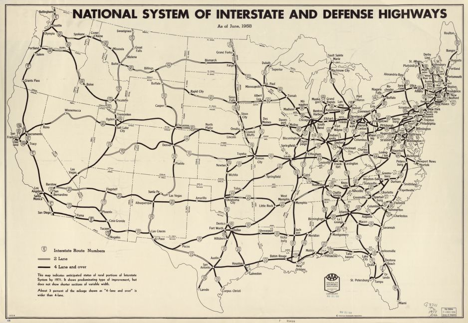
After the National Interstate and Defense Highways Act of 1956 was signed by Eisenhower, there was a need for a map to display the vision of such a massive project. There is where one of the main proponents of the National highway system AAA, came into play. With the organization being around for half a century it established credibility for holding the public’s best interests at heart. This is shown through education programs enacted in schools, providing service to stranded motorists, legally taking action to seemingly unjust laws, and making available touring information open to the public. Eisenhower wanted to launch the United States into a secure future where all the people would have access to the splendors of the country by solely having ten fingers make contact with a steering wheel and therefore granting endless opportunities. But like any visionary there are obstacles that are imposed, and Eisenhower couldn’t oversee every detail. This resulted in a committee of men each with his own interests at heart having to come together to make a national highway, while simultaneously balancing each state’s values. The attempt to appease the states can be conveyed by the physical establishment of the veins of the interstate that seem to have been ensured passage in each state at least twice. Whether the concept is highlighted through the tension amongst revealing and concealing or Newton’s third law of motion, there seems to be an unspoken side along with every visible story. Such hidden details brought up in class were:
· Waterways
· Names of states and the country on the map
· Accuracy of cities along the interstate routes
· Cities once well known are no longer on map
· Values
In conclusion, as scientific, innocent, and unbiased as a map may seem there is sufficient evidence to support the claim from Dr. Salisbury that “every map is a lie,” each in its own particular way.
Marissa Nino and Vanessa Kowalski
thanks for sharing this information with us. i enjoy read this article and great conclusion