
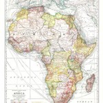

In the words of Denis Wood, “mapmaking fuses its growth and development with history, in the transformation of the world” (Wood 47). The National Geographic Magazine map of Africa from 1909 shows modern viewers the continent of Africa in a time of European conquests and commercialism. This map is particularly significant because it shows one of the first views of the continent of Africa through American eyes. With advances in technology, education, and a growing sense of American identity, the nation was steadily on its way to becoming an international power. Along with this growing power came an interest among the people to discover more about the world outside of their American bubble. The National Geographic Society, founded in the 1880s, allowed Americans to explore the geographies, relationships, and cultures of the other continents of the world through pictures, essays, and maps collected and published in the National Geographic Magazine. Though young America took no part in the conquest and colonization in Africa, this map shows a snapshot in time of the influence of European nations in Africa in 1909. It indicates the territorial claims in 1909, resources and goods located throughout the continent, and railroads and ocean liner routes leading within the continent as well as out onto the ocean.
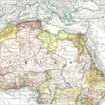
The first thing the viewer notices on this map is the motley of pastel colors. These colors represent the territorial claims to Africa during this time period. During the late 19th century, European nations began to colonize the continent, beginning the “Scramble for Africa.” The Berlin Conference in 1884 allowed the nations of Britain, France, Germany, Italy, Portugal, Spain, and Turkey to divide the land up into territories (“Imperialism”). During the conquest of these lands, the powers faced resistance from the Africans, especially in West Africa, but the natives were overpowered due to the Europeans’ superior weaponry (“Expedition Africa”). The viewer perceives that most of the northern area of the continent is colored pink or a darker variation of pink, signifying French and British territory respectively. A large area labeled “French Territory,” located mainly in the northwestern area, includes a number of countries such as Algeria, French Guinea, Senegal, Dahomey, and the Ivory Coast. These territories were conquered by imperialists largely in an effort to regain power lost after France’s defeat in the Franco-Prussian War (“East Africa in the 19th Century”). The lighter pink in the northeastern area, including “Anglo-Egyptian Sudan,” shows Britain’s claims. The Anglo-Egyptian Sudan refers to the area of East Sudan which was ruled by a joint British and Egyptian government from 1899 to 1955 (“Anglo-Egyptian Condominium”). Other British territories shown include Uganda, Nigeria, Gold Coast, and Sierra Leone, all territories kept by Britain for purposes of commerce and production (“Southern Africa”). A noteworthy number of territories are also colored with the yellow signifying “Independent Territories and Congo State.” Abyssinia, a territory of modern day Ethiopia, became independent in 1889 with the compromise of the Treaty of Wichale in which Italy was given an area north of the territory, Eritrea, which we see shaded in the dark orange signifying Italian control (“Abyssinia”). The Congo State was a colony of French Congo beginning in 1891, becoming a republic within the French Community and later acquiring complete independence in 1960 (“Republic of the Congo”). This map is primarily an artifact telling the history of European imperialism in Africa. The color-coded areas of control demonstrate the power inflicted by those nations on the natives of Africa. One thing this map does not convey is the fact that natives were often treated with brutality and disrespect from the Europeans, who were forcefully exploiting their resources. The map shows the influence of the empires with no perspective on the native people of the area. The various colors of the map, upon close inspection, represent a very intricate story of each territory’s history with foreign relations in Europe.
Another important topic this map demonstrates is the production of natural resources throughout the territories of Africa. This is a significant detail because the products available to harvest or cultivate in any specific area were an important factor of interest in the territories of Africa. The “Principle Products” appear in red lettering over the map, marking the locations of products such as wine, iron ore, pearls, myrrh, coal, gold, ivory, palm oil, ebony, and rubber. Because of the continent’s vast supply of these materials, European conquest brought Africa into the global economy, which was a big step for the continent. However, they were brought in on unfair terms due to European control over the territories where the materials were found (“The Scramble for Africa”). A prominent example of this is the British control over the Cape Colony. As we can see from the map, the Cape Colony located at the southern tip of the continent is rich with minerals, in particular gold, silver, copper, and coal. Britain quickly annexed this area in the late 18th century, right along with Germany’s annexation of South-West Africa and Portugal’s annexation of Portuguese East Africa. By 1895 all of the African territory south of the Congo State were annexed (“Southern Africa”). Similar stories apply for the other territories claimed by European powers for the purpose of production and commercialism. The red markings on the map are an important piece of the story of European imperialism in Africa because they reveal why countries chose to conquer the territories.
Another significant piece of information we can draw from this map is the transportation systems both within and outbound from Africa. This information is an important factor in understanding the means of exploration and transportation for the powers controlling much of the continent. Inbound, we can see that the railroads (both in operation and proposed) run all across and up and down the continent. There are also many caravan routes running mostly in the northwest territories. The ocean liner routes appear to have very frequent ports along the coasts of the continent, but particularly on the western coast. The Canary Islands, a supplier of wine, sugar and bananas, has six different routes running through their waters. Large ports seem to be located at Freetown in British-controlled Sierra Leone, a supplier of sugar; Monrovia in independent Liberia, where gold and wine are marketed; Lagos in British Nigeria, a provider of many products including cotton and sugar; and most prominently, Cape Town in the British Cape Colony. There appear to be about six ocean liner routes leading in and out of Cape Town, with destinations of Hamburg, Southampton, and Australia. The great number of routes leading out of the southern tip is justified by their high supplies of minerals, especially gold. Though the ports on the eastern coast are far between, there seems to be much interest in the ports of Suak-in in Anglo-Egyptian Sudan, a producer of tobacco and gums; Dar-es-Salaam in German East Africa; and several in Portuguese East Africa. The ports are an important feature of this map because they emphasize the importance of trade routes from the territories. Likewise, the railway and caravan routes show the means of transportation of goods for countries not located on the coast. These routes, clearly not a part of the native Africans’ culture, show the forceful European modernization of the native land for the purpose of exploitation of goods. The transportation system markings on this map add depth to the story of European control in Africa.
This map offers a powerful insight into the culture of Africa in 1909. It is important to consider that the map was created by American National Geographic, while we had no part in the actual goings-on in Africa at the time. The production and publication of this map reveals American interest in affairs abroad, a sentiment caused by our growing sense of identity and presence overseas. Through the color coded territorial claims it is easy to see the power of predominantly France and Britain along with other countries at the time. The resources written along the terrain help provide perspective to the issue of production and commerce. Lastly, the transportation routes, in particular the ocean liner routes, show the viewer both how the people of Africa and goods were transported among countries as well as to the rest of the world. Though at first glance the map appears to be a standard representation of the continent, deeper examination reveals the powerful story of European imperialism in Africa, gained largely through force and incivility toward the natives. National Geographic provided not only a resource for early 20th century America to see this perspective on Africa, but also an insight for viewers today into the world in 1909.
Lily Calaycay
Works Cited
“The French in West Africa.” The French in West Africa. N.p., n.d. Web. 24 Sept. 2013. <http://courses.wcupa.edu/jones/his312/lectures/fren-occ.htm#algeria>.
“The British in West Africa.” The British in West Africa. N.p., n.d. Web. 24 Sept. 2013. <http://courses.wcupa.edu/jones/his312/lectures/brit-occ.htm>.
“Abyssinia.” Encyclopædia Britannica. Encyclopædia Britannica Online Academic Edition. Encyclopædia Britannica Inc., 2013. Web. 19 Sep. 2013. <http://www.britannica.com/EBchecked/topic/2494/Abyssinia>.
“Southern Africa.” Encyclopædia Britannica. Encyclopædia Britannica Online Academic Edition. Encyclopædia Britannica Inc., 2013. Web. 19 Sep. 2013. <http://www.britannica.com/EBchecked/topic/556618/Southern-Africa>.
“Anglo-Egyptian Condominium.” Encyclopædia Britannica. Encyclopædia Britannica Online Academic Edition. Encyclopædia Britannica Inc., 2013. Web. 19 Sep. 2013. <http://www.britannica.com/EBchecked/topic/25025/Anglo-Egyptian-Condominium>.
“Republic of the Congo.” Encyclopædia Britannica. Encyclopædia Britannica Online Academic Edition. Encyclopædia Britannica Inc., 2013. Web. 19 Sep. 2013. <http://www.britannica.com/EBchecked/topic/132321/Republic-of-the-Congo>.
“Algonquin College – Expedition Africa – Small World Big Picture.” Algonquin College – Expedition Africa – Small World Big Picture. N.p., n.d. Web. 24 Sept. 2013. <http://lyceum.algonquincollege.com/swbp/africa/main/articles/History-Scramble.htm>.
“East Africa in the 19th Century.” East Africa in the 19th Century. N.p., n.d. Web. 24 Sept. 2013. <http://courses.wcupa.edu/jones/his312/lectures/eastafr.htm>.
“Imperialism.” History Haven. N.p., n.d. Web. 24 Sept. 2013. <http://www.historyhaven.com/APWH/unit%204/IMPERIALISM.htm>.