The Middle East definitely receives a substantial amount of global media attention; however, it is often a misunderstood region. Even outlining the Middle East on a world map creates controversy amongst scholars. Should the region’s border be based on common history? Language? Religion? Culture? The fact of the matter is that the Middle East (wherever that may be) has such a diverse background that trying to fit it into these ridged categories does not do justice to its true diversity. The Middle East Mapping Initiative at Richmond (MEMIR) strives to illustrate the unique characteristics of the contested expanse utilizing a geospatial platform.

Rather than looking at a chart with quantitative data, ArcMap (ESRI’s Geographic Information Systems (GIS) software used by the University) projects statistics onto a map, giving it a place and context – a key tool for young academics unfamiliar with the layout of the Middle East.
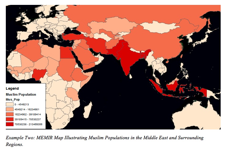
In the Spring of 2011 the Middle Eastern geographies class utilized GIS to create informative visuals illustrating key concepts discussed in the classroom. With no prior GIS experience all of the students executed great maps by extracting data from the University’s extensive MEMIR database. With these visualizations students learned that Muslim populations are not concentrated in Western Asia, but rather they are more prominent throughout India and Indonesia, clarifying the misconception that the Middle East is the same as the Islamic world (See Example Two).
Students also constructed an illustration of the different extents of the varying definitions of the Middle East (See Example One), and even compiled images to create a mini movie showing the growth of populations in urban areas throughout Middle East (See Example Three).
Urbanization in the Middle East
Example Three: MEMIR Video Illustrating Urbanization in the Middle East and Surrounding Regions
I know for me at least that these exercises really expanded my true understandings of the “real” Middle East. Therefore, I encourage all academics to employ this powerful technology into their work in some shape or form, and we (the interns) are in the Spatial Analysis Lab to aid in transforming your vision into a tangible and informative project.