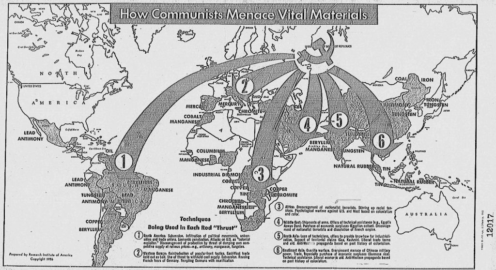
“How Communists Menace Vital Materials” of 1956 conveys deliberate and overt American biases as the U.S. finds its place within the Cold War climate. During the 1950s, American life was wracked with the paranoia of the Red Scare, which was only magnified with Joseph McCarthy’s strong accusations and the following espionage trials. The map itself was published in a 1956 Congressional report by the Research Institute of America, and the report arose out of the Committee on Un-American Activities. With large arrows and stark contrasts between darkened and lightened countries, the map depicts how the Soviets attempted to “conquer world capitalism” by exploiting raw materials around the world. The text at the bottom of the map reveals the tactics by which the Soviets managed to acquire these resources, such as by subversion or negotiation.
Regarding its point of view, the map portrays an extremely conspicuous American bias with the usage of words like “menace” and “thrust”, and the size and expanse of the arrows instills a sense of urgency within viewers. Nevertheless, the map hosts other more covert interests; it also holds a very economic purpose. Some of the resources included rubber, copper, and lead, all of which could be used for war-making or industry-building. The U.S. demanded these materials for its operations, as well, so the Soviets’ “menacing” of these materials creates an economic motive for the U.S. to aid these exploited areas. By the same token, the map connects the regions and countries to their resources. With this clear visual, these countries possess larger economic power, and audiences can more easily understand what drives the economies in each of these areas. Furthermore, the usage of projection inherently stirs up more bias. The map appears to demonstrate a Mercator projection that is more Euro-centric. Therefore, the cartographer guides the primary focus back to the brewing conflict between the U.S. and the U.S.S.R.
One anomaly is that there is no legend on the map. Many would argue that it does not quite need one, but this lack of a legend distinguishes the map from most others. In addition, the map essentially defines countries by their resources and economic power. Their names and other functions are either difficult to read or not present on the map; therefore, in this sense, they are stripped of their sovereignties and defined by solely one trait. A third critique is that although the mapmaker criticizes Soviet methods of resource extraction, the U.S. used similar methods during the colonial period to obtain economic and political dominance. Americans thus contradict themselves by illustrating themselves as saviors and models for others. Finally, the mapmaker made conscious decisions to include the listed resources over others. Why were these resources chosen? They likely served some sort of military significance to both the Americans and the Soviets, but this choice is most certainly a political one.
By Nora Geer and Heather Neiman

