
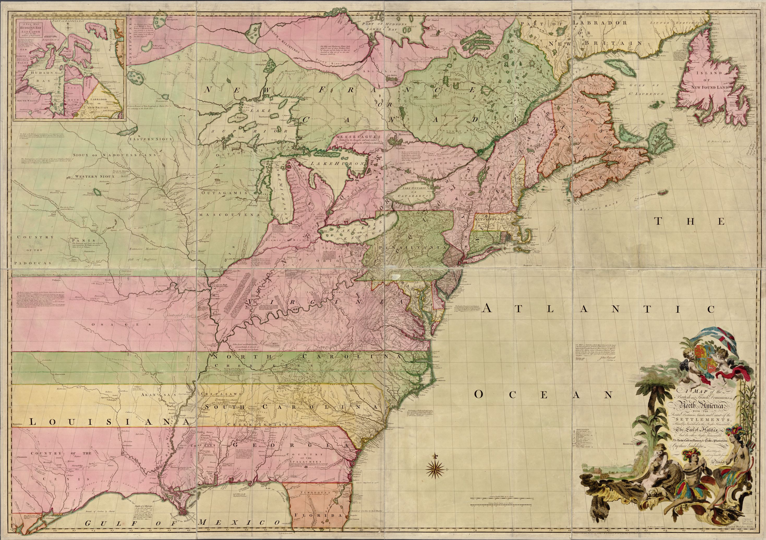
The absurdity of the portrayal of the colonies’ extension across America is not quite like any other map that I have seen. Few maps are as dramatic in their presentation as John Mitchell’s map of the colonies. Its colonies sweep out all the way to the pacific coast without even knowing what lies beyond the east coast. This map of the territories in North America is pivotal in its rhetorical power and geopolitical influence on those who viewed it. The full name of this map is “A map of the British and French dominions in North America, with the roads, distances, limits, and extent of the settlements, humbly inscribed to the Right Honourable the Earl of Halifax, and the other Right Honourable the Lords Commissioners for Trade and Plantations.” (Congress) This map came about before the Revolutionary War and during the French and Indian War. John Mitchell was commissioned by the Board of Trade of Great Britain to produce this map in the year 1755. By viewing this colonial map three themes occur in regards to its appearance and power. This map is highly detailed, rhetorically significant in its manipulative power over foreign policy, and shows colonialism in its portrayal of the colonies.
The attention to detail can be seen in almost every part of the map. Inscribed at the lower right hand corner is a cartouche that identifies the recipient of the map – The Earl of Halifax. The Earl of Halifax at that time was George Montagu-Dunk who was the head of the Board of Trade. He had major influence over the colonies including expanding trade in the region earning him the name “father of the colonies.” (George Montagu-Dunk, 2nd Earl of Halifax) Maps such as this act as a symbol of power. By having a map with his name on it George Montagu-Dunk can legitimize himself through the ownership of the map. The attention to detail can also be seen in the inset on the upper left that examines the Hudson Bay and the areas around it showing its importance to the population in that region. In addition, there are strategically placed comments throughout that map pointing out information about the natives and French and English settlements. On the overall appearance of the map, some of the thirteen colonies are identified in bright colors and New France is identified to the north of these colonies in green. The map itself is brightly colored and hand drawn, identifying different territories during that time period. In regards to points of interest, the map includes, “roads, distances, limits, and the extent of settlements.” This attention to details plays into the maps function as a rhetorical device.
Rhetorically this map has a significant amount of power over British foreign policy. The comments in this map exist to shape the viewers understanding of the situation in the colonies. These comments are as much of a rhetorical device as the selection of one map projection over another. All maps make decisions about leaving things in, versus taking things out. These comments are an example of those decisions. For instance, there are two long paragraphs explaining Native American movements in what is today Illinois. These comments and others serve as a way to purport a major Native American influence in this region. This serves to use fear to convince the British people that the Native Americans were a problem that needed to be dealt with. This map was produced during the French and Indian War and helped to gain support for Britain’s involvement in the war. The Colonial Williamsburg Foundation owns this map and has done research on its origin and overall context. The Foundation has concluded that this map was extremely influential in its ability to swath the British people to keep control of the colonies. (Foundation)
The rhetorical decisions do not stop with the remarks about the Native Americans. In addition, comments about the French are sprinkled throughout the map creating the idea that the French are sweeping through North America. For instance, on the south of Lake Erie a comment states “usurped by the French 1751”. (Congress) By placing this comment the author creates a narrative that points toward French encroachment.
In addition to these comments, the way the colonies are portrayed shows a noticeable colonial arrogance. The colonies of Virginia, North Carolina, South Carolina, and Georgia are all extended to the edge of the map. This is done in a manner that lacks regard for any people groups in the areas that are bulldozed over by these arbitrary borders. These lines seem to be drawn arbitrarily westward with no real understanding of the implications that the boundaries create. This was a time period when the seeds of rebellion were being sown and discontent with the Crown was more evident every day. It could have come off as a major insult that the Crown was claiming almost all of America for itself and fueled rebellion. The colonies seem to push infinitely into the west claiming all of the territory in the name of England. The map shows the British claiming land that they barely knew existed. This creates an incorrect perception that the British people have a right to all the land. Unfortunately, today, we seem to forget that we were once a colony that was taken advantage of by a stronger power and not given a say in how it wanted to be governed. We must see that this map, in its attention to detail and rhetoric, points toward us today and asks what kind of country we want to be in our dealings with our less powerful counterparts.
References
Congress, Library of. A MAP of the/ British and French Dominions in/ North America,/ WITH THE/ Roads, Distances, Limits, and Extent of the/SETTLEMENTS,/ Humbly Inscribed to the Right Honourable/ The Earl of Halifax,. n.d. 21 March 2017. <http://emuseum.history.org/view/objects/asitem/classification@17/15/title-asc?t:state:flow=06387ae4-812a-4ad4-943f-f337cdd89396>.
Foundation, Colonial Williamsburg. “A map of the British and French dominions in North America, with the roads, distances, limits, and extent of the settlements, humbly inscribed to the Right Honourable the Earl of Halifax, and the other Right Honourable the Lords Commissioners for Trade &.” n.d. Library of Congress. 21 March 2017. <https://www.loc.gov/resource/g3300.np000009/>.
George Montagu-Dunk, 2nd Earl of Halifax. n.d. 21 March 2017.
I think this map adds a nice contrast to the maps we have looked at in class and the other Maps of the Week posts. Almost all of the Maps of the Week posts focus on maps made during the 20th or 21st century and recently in class we looked at maps from the Cold War. A map of colonial America provides insight into the power maps have in an empire. This map claims land that had not been heavily explored or settled by the British colonists. They could not have know for sure what, if anything, lay to the west. However, by drawing lines on the map the British empire claimed ownership of that land. It did not matter if Native American tribes had been living in that territory for centuries, as soon as those lines were drawn, any ownership they had over that land was lost. I also believe that this map foreshadows American imperialism and manifest destiny. As evidenced by this map created in 1755, westward expansion filled the minds of Americans before the United States as it is today even existed. Parallels can even be drawn to today’s maps. Dr. David Salisbury talked to us about the silences in today’s maps and the legal impact they have on remote societies. Just as Native American tribes once lost their right to the land when this map was drawn, today, so do remote villages when huge swaths of land are divided up for logging in the Amazon. It is fascinating that the same problems that were encountered hundreds of years ago still plague us today.