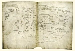
On the eve of Columbus Day, 1965, Yale University issued a statement that they possessed a map that disputed the agreed upon fact that Columbus discovered the New World. After this announcement, Yale received visits from many esteemed historians attempting to study the famous Vinland Map. Historians were enthusiastic about the new development of an authentic Viking map; the public’s reaction, far less accepting. The Vinland Map challenged the core knowledge of many Americans’ cultural heritage. Protests occurred and more attention was drawn to the map. As it turned out, more eyes didn’t help. Instead, historians were torn between authenticating the map and decrying it as a fake. All the evidence pointed to the map being forged by someone in the 1950s.
The Vinland map’s heavily debated authenticity is something to focus on. How is it that a map, with glaring falsities—like ink that was created in the post-Atomic era, and depictions of Greenland inconsistent with the beliefs at the time—can still be considered real? To some extent, some blame must be placed on Yale historians: the map was carbon dated to around AD 1434, was bound in an anthology of verified Medieval documents that had been collected by the Catholic church, and the black ink followed the process of yellowing and browning like a document contemporary to the time would (McCulloch). Yale historians saw these markers as undeniable proof and left their analysis of the map at that. The Vinland map would be an amazing collector’s item for Yale: the implications of this map were great enough, ground breaking enough, that despite the evidence against the map the context this map implied should be considered.
Not only are maps considered historical documents, their context regularly remains unquestioned. A map can be found of Jerusalem in the 1200’s that is wildly inaccurate, however it will be taken at its face value. The biases that the mapmaker had go unquestioned because the creators of maps often remain invisible. This phenomenon of the invisible author remains true in modern maps as well—historical maps simply have help write the history of a time period. A map like the Vinland map could very easily shift Viking history as we know it.
The Vikings were a civilization built on maritime travel, but up until the discovery of the Vinland Map it had been assumed that their voyages were done without maps. The Vinland Map verified many things: the use of maps in Viking society, knowledge of America pre-Columbus by the Catholic Church, and settlements in North America almost a century before Columbus. The map was released on the eve of Columbus Day, a publicity stunt by the university, and effectively outraged both American and European citizens alike. Suddenly the world-wide pat on the back that Columbus received was unwarranted (not that it wasn’t to begin with, but that’s another story) and the Americans who traced their lineage back to Columbus’ voyages felt somewhat lost on the importance of their heritage. This map questioned the identity many Americans found in Columbus’ discovery. The Vinland map muddled the authenticity of Spain’s discovery of the New World. Archaeologists questioned their findings in Scandinavia and historians took another look at the texts published on the Viking culture. Sooner, rather than later, archaeologists began new digs in Canada in an attempt to verify the settlement displayed on the map (Smithsonian Channel).
If all maps are biased and do not fully show the reality of the time—then what does a fake map show? As the years have passed more and more historical cartographers have labeled the map a ‘clever forgery’ (Goldstein). In 2008, Ohio State University published a 62-page paper that contained a majority of the evidence against the Vinland Map, and yet… The map continues to be cited to counter the argument of Columbus discovering the New World. Maps are used to interpret and help grasp the vastness of the world around us, in turn they are viewed as the reality. The Vinland Map quickly became the perceived reality of the 1430’s. Without developing news covering the dismantling of the map’s authenticity, the public continued to believe that the Vikings settled in American and the Roman Catholic church knew. Fake as the map was, it became part of their perception of history. As it turns out, even a fake map can impact history.
Secrets? A Viking Map. Documentary. Directed by Kenton Vaughn. 2012. Smithsonian Channel.
Goldstein, Thomas E. Conceptual Patterns Underlying the Vinland Map, (19:4, 321-331). Renaissance News, 1966
McCulloch, Huston. The Vinland Map—Some “Finer Points” of the Debate. Ohio State University. March, 2005.


The processes of recovering this ancient map remind me of the exhausting process of putting together the cloud-free satellite image of Earth that we studied from Wood’s book. Carbon dating and recovery sciences are necessary in analyzing this map. A certain percent of uncertainty could be the difference between Columbus retaining his credit for discovering the New World and not. This is just another example of how the hidden science behind mapping affects the map itself. I also think your point about a false map is very thought-provoking as well. Again to reference Wood — if a map is never 100% accurate, at what level of inaccuracy is the map considered “false”?