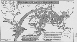
This map, published in 1956 and produced by Research Institute of America, shows the USSR’s attempts to extract resources from around the world during the early days of the Cold War. Research Institute of America was founded in 1946 as a nonprofit, nonpartisan behavioral and social science research organization. Originally interested in aviation and education, the organization has since expanded research into international development and health.
This map’s original purpose was to display to Congress how large of a threat the Soviet communists posed to American interests. It is important to note that this map was drawn just following the height of the Red Scare, a period when Americans were wary of communism possibly infiltrating the US or our allies. With Joseph McCarthy’s threatening philosophy at the forefront of Congressmen’s minds, the overbearing bold arrows and large hammer and sickle icon sit ominously at the center of the map. The USSR’s forces extend out like a spider web, reaching the far corners of the world.
It is essential for us to analyze this map and all its features while remembering the overarching conflict of the Cold War. The long militaristic power struggle between the US and USSR was only still in its early stages at the time this cartographic text was made. The map is a form of propaganda, used by capitalists to showcase the risk communism caused and persuade Congress to act against Soviet power.
M. J. Heale’s book McCarthy’s Americans: Red Scare Politics in State and Nation, 1935-1965 includes this interesting tidbit regarding 1950’s-era US policy: Amid tensions within Congress itself, there was a great emphasis on passing anticommunist propaganda in institutes of higher education. Heale states, “Education was a major responsibility of state governments, and red scares thus often focused on colleges or schools.” He goes on to explain that when the red scare phenomena were at their “most destructive,” congressional committees targeted universities with the intention to “stamp out Communism in out educational system.” We can infer from this that the techniques used in Congressional hearings, such as anti-Soviet maps and other cartographic texts, were effective enough in communicating their message that legislators fixated on influencing the next generation as well as their peers.
Heale, M. J. (1998). McCarthy’s Americans: Red scare politics in state and nation, 1935-1965 (p. 4, 86, 297). Athens, GA: University of Georgia Press.

