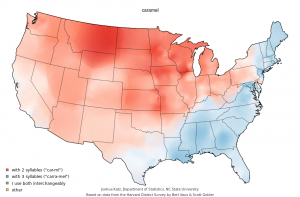
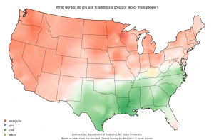
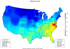
We’ve all disagreed with a friend or two about the pronunciation of a word at one time or another. Language, however, is more than a function of history. Geography has a major impact on the lexicon an area uses. By affecting a number of linguistic components, including lexicon and accent, geography plays a major role in developing regional dialects. While looking around various social media sites, I stumbled across a website that lets you explore such questions as “Am I crazy for pronouncing caramel as ‘car-ml’?” and “Why does Jimmy use ‘you guys’ even though Helen uses ‘you guys’? They’re both from Florida!”
Constructed by Joshua Katz at North Carolina State University, the series of maps illustrates data collected during the Harvard Dialect Survey conducted by Bert Vaux and Scott Golder.
Found on spark.studio.com (at http://spark.rstudio.com/jkatz/SurveyMaps/), this set of data offers over one hundred individual maps relating to regional dialects in the United States. They include the pronunciation of individual words, usage of various phrases, and regional names for objects and activities. Further, it notes the most and least similar cities to the selected option. Additionally, the site allows filtration of data maps answering individual questions on city, static, and ‘click’ levels. In addition to the various maps created using geographic information systems (GIS), this site hosts a number of interesting links that allow you to personally relate to topics in geography related to linguistics. The primary links related to personalizing the experience are a quiz that allows you to discover what kind of dialect you have and an aggregate map of dialect differences (http://spark.rstudio.com/jkatz/DialectMap/). This set of maps displays the level of similarity between areas based on the one hundred and twenty two questions asked in the survey. Further, it notes the most and least similar cities to the selected option.
Though the site does not specifically relate to physical geography beyond highlighting the various tools a geographer may use, such as GIS and survey for data collection, the maps indirectly highlight the historical and cultural significance of major land forms in the United States. For example, the use of terms to refer to a group of two or more people changes with the region, indicating that the dispersal of individuals spatially altered the lexical preference of individuals. Further, mountain ranges appear to impact specific questions, suggesting that physical barriers may have influenced dialect usage. Rivers and bodies of water interact with aquatic transportation in a similar manner, acting as connecting forces for regional dialects.
I find this site particularly interesting because it uses various tools of the geographer in an interesting way that engages individuals from around the United States. It applies spatial analysis to a language, inviting people from a number of backgrounds to the conversation. It acts as an engaging tool for people of all ages and backgrounds interested in comparing aspects of regional dialect.


It is interesting to see the way that different regional dialects develop within a language in the same country. In Nepal, where many villages are accessible only on foot, there are more than 27 languages spoken due to the separation of these groups. I wonder how long it would take for the differences in U.S. dialect to become significant enough that they are considered different languages or whether this is possible given populations’ access to travel.
Really cool site, I’ve seen the maps before on buzzfeed, but never knew there was a quiz. My results were spot on, my county in central jersey was dark red- who knew New Jerseyans are the only one’s with mischief night and that we think “Mary” “merry” and “marry” are all pronounced differently.
This is a really interesting use of GIS to show the spatial dispersion of dialects in the US. As you said in your post, these maps show how dialects have been determined due to geographical features, which have broken up the nation into regions. I think its really interesting to see where these lines divide us. For example, in NJ there was often a split right through the center- this is definitely evident due to the North/South Jersey split either favoring NYC or Philly.
Even more interesting is the difference in word usage rather than pronunciation. Why in the world do some people from Massachusetts called a “water fountain” a “bubbler.” Maybe I missed it, but it would be cool if the site provided some more details that explained why dialects and word usage different for each specific thing.
Overall, a fun and interesting site. Thanks