TIME Magazine recently published this disturbing image titled “A Map of Trouble” (TIME, Jan. 3 2012; 26-27). My response and my counter-map are inspired by the work of Mark Monmonier (How to Lie with Maps) and J.B. Harley (Maps, Knowledge and Power).
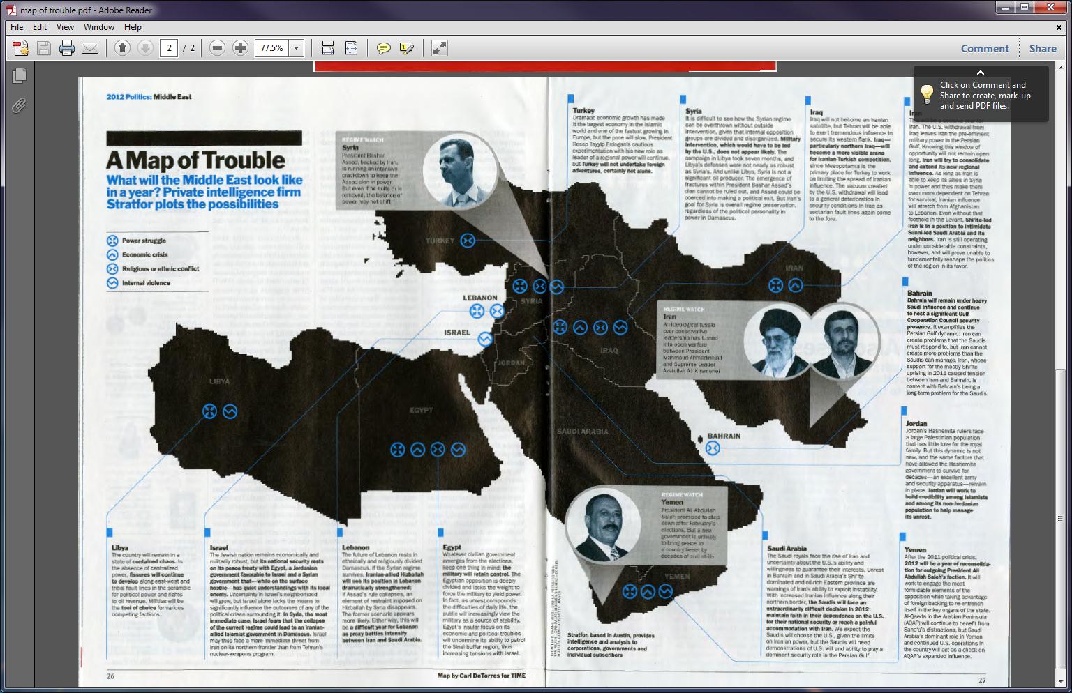
First, the title and the graphic shape of the “region” are linked together in the reader’s mind. Trouble = Middle East = Bad is the not-so-subtle message.
TROUBLE = 
In the same way that:
LOVE = 
and
HAPPY =
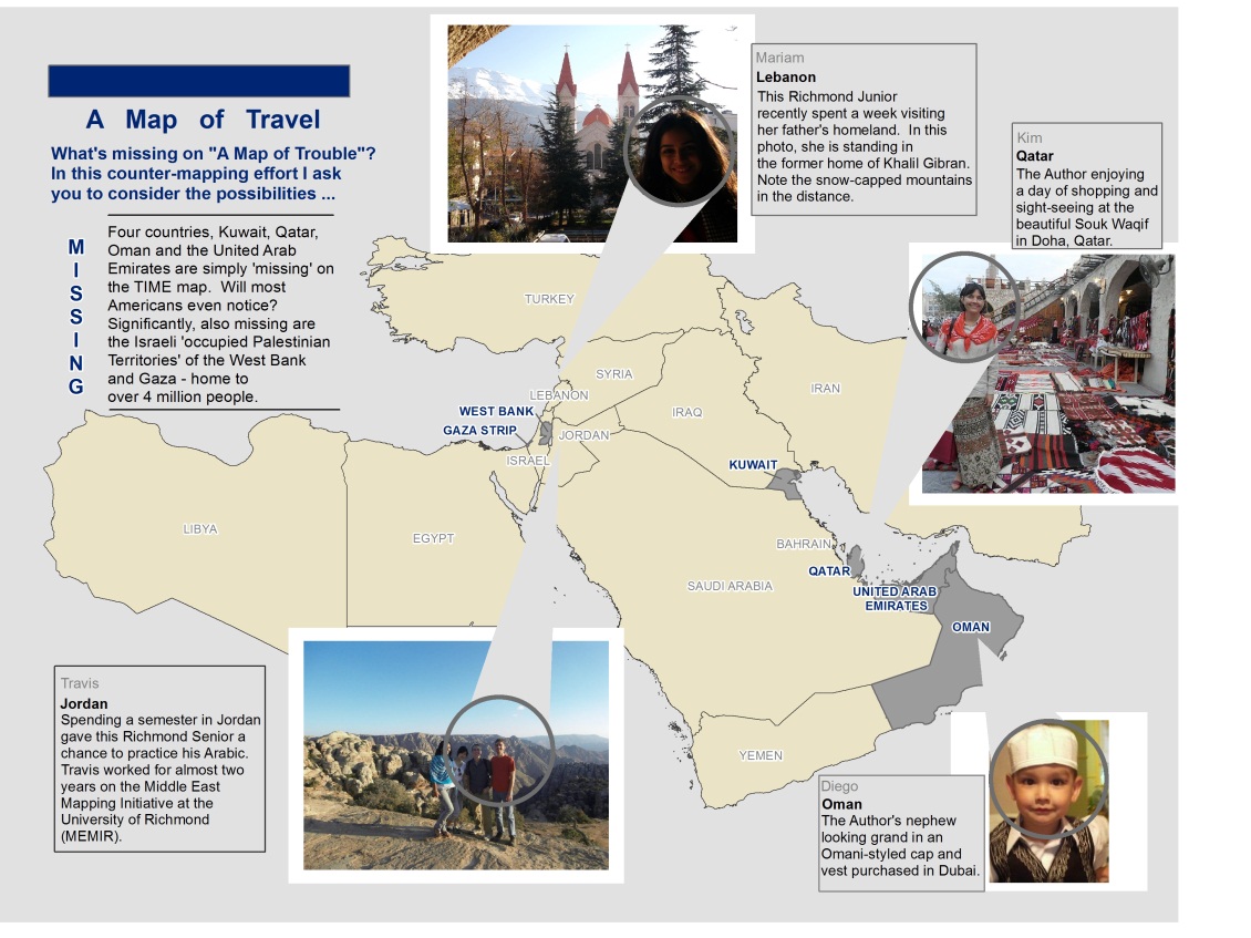
 Second, the lack of color, the choice of markers resembling hazardous waste dumps, and grey-scaled photographs of men (disturbing ‘others’) help to reinforce the negative message of the map. Contrast these with the colorful photos included on my “Map of Travel”. For Harley, “maps are never value-free images.” “Both in the selectivity of their content and in their signs and styles of representation, maps are a way of conceiving, articulating, and structuring the human world which is biased towards, promoted by, and exerts influence upon particular sets of social relations (Harley 278).” “A map can carry in its image such symbolism as may be associated with the particular area, geographical feature, city, or place which it represents (Harley 279).” How might our perspective change if we were constantly bombarded with maps and images of smiling people, beautiful scenery and colorful markets?
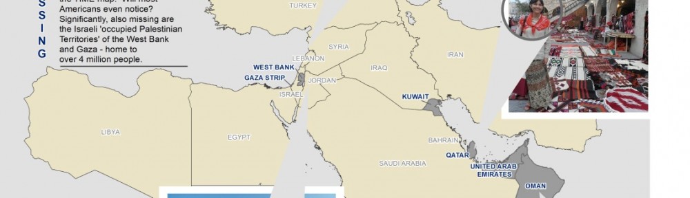
Third, the map contains several blatant omissions. The countries of Kuwait, Oman, Qatar, and the United Arab Emirates are simply NOT THERE (neither is Afghanistan or Cyprus for that matter). The four absent countries fall within the extent of the map – will they not be missed? Why were they excluded? Harley says “maps – just as much as examples of literature or the spoken word – exert a social influence thru their omissions as much as by the features they depict and emphasize (Harley 290).” Significantly, the Israeli-occupied territories of the Gaza Strip, and the West Bank (aka the PALESTINIAN TERRITORIES) are neither on the map nor mentioned in the vignette. Could this be a case of the “predictive art of using maps to project and to legitimate future territorial ambitions? (Harley 289).” Or was this simply an oversight?
“Map users seldom, if ever, question these [the map makers], and they often fail to appreciate the map’s power as a tool of deliberate falsification or subtle propaganda (Monmonier 42-45).” “Savvy map viewers must recognize that not all maps are intended solely to inform the viewer about location or geographic relationships. As visual stimuli, maps can look pretty, intriguing, or important. As graphic fashion statements, maps not only decorate but send subtle or subliminal messages about their authors, sponsors, or publishers (Monmonier 43-45).”
Counter-maps – maps of peace, maps of potential – maps of nuance – must be created and shared to balance overly simplistic and negative maps. This is one of the chief motivations behind MEMIR – the Middle East Mapping Initiative at Richmond. Join us!
