Post by Heather Courtenay ’16
In the background of the rest of the SAL research, Dr. Lookingbill and I have been working on revisions for a paper that was started last summer on Booker T. Washington National Monument (BOWA). The paper is a Natural Resource Condition Assessment (NRCA) for the National Park Service, which is formulated to assess and record park resource conditions, accompanying more traditional threat-based assessments. An NRCA reports on the current and trending conditions, data gaps, and confidence levels for selected park natural resource indicators. The report can be used by park managers to address park priorities, identify data needs for resources, and further communicate park resource conditions to wider audiences. The goal of the report is to provide information based on scientific data and analysis, which can then be used in park planning and partnerships.
Booker T. Washington National Monument memorializes the birthplace of one of America’s most influential African American, Booker T. Washington. The site was established as a National Monument in 1956 by Congress. Today, BOWA is a 239 acre park that contains many interpretive replicas of buildings and farm installations, as well as a visitor’s center and an old school building. The park is within the Piedmont region of Virginia, and is situated in the Roanoke River and Albemarle Sound watersheds. Threats to the park’s natural resources are found inside the park (e.g., invasive species, erosion), outside the park boundaries (e.g., water contamination), and the greater region (e.g., air pollution).
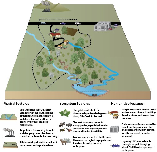
Key Characteristics of Booker T. Washington National Monument in a conceptual diagram showing the natural resource assets and stressors in and around the park.
Multiple metrics are used to assess the health of the park, and datum must be collected from various monitoring reports, such as the National Park Service Inventory and Monitoring Program, and park-specific databases. Once the 16 vital sign metrics were identified, a threshold level was set based on scientific literature and management goals. This threshold acts as a reference point from which to gauge the status of the vital sign. Attainment of thresholds for each metric were calculated from the percentage of sites or samples that reached or exceeded the threshold value. A metric attainment score of 100% indicated that the metric met the threshold identified to maintain the resource in all instances. Once all of the attainment scores were calculated, an unweighted mean was calculated to assess the condition of each vital sign category for the park as a whole. The natural resources of BOWA were found to warrant moderate concern, reaching 57% of desired thresholds.
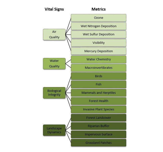
Vital sign categories and metrics used in assessing of Booker T. Washington National Monument
In order to give visual context to the report, many maps and figures were created to represent things like geologic formations, sampling points, and watershed contexts. Most of my job this summer has been standardizing these maps to a set format, as well as resolving data gaps. Supporting the large amount of data contained in the NRCA with comprehensive maps significantly increase the accessibility of the information, which is vital in a public arena such as the National Park Service.
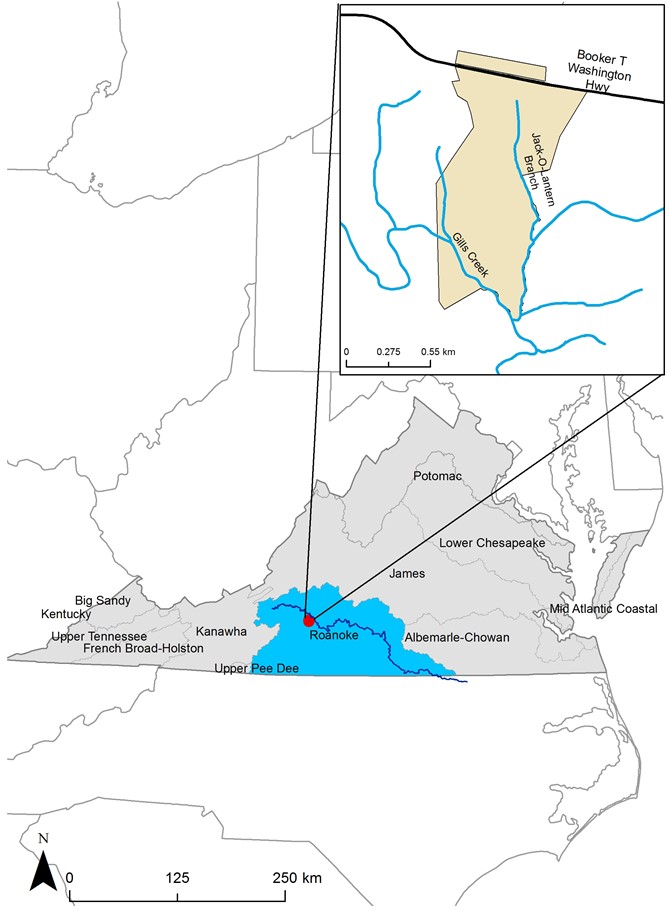
Watershed Context of Booker T. Washington National Monument, in the Upper Roanoke River Watershed