Portland 1
- Place is a location that one associates a unique meaning or characteristic towards in order to distinguish it from other locations. However, Banis and Shobe argue that there are many different framings and viewpoints that can be associated with a place. For example, this summer I am situated at Miami, Florida which is a place generally associated with year-round summers, beautiful beaches, and a diverse Latin setting. Although these characteristics are not wrong, Miami, Florida for me is much less glorified than what the populous thinks. I think of Miami as constant blistering heat wave, with overwhelming traffic roads, and the home of some of the rudest people in the states; I frame Miami in a way that sounds much more negative, yet also true nonetheless.
- I have always stereotyped Portland as a city of hipsters and all things weird, as well as a city with a great appreciation for the outdoor scene and wildlife. Banis and Shobe support both of these assumptions in the introduction. Portland is referred to a city containing high densities of food carts, breweries, coffee shops, carless commuting, and a unique art. The people are much more relaxed and adopt a “countercultural lifestyle that puts quality of live over material possessions and social status which definitely strays from the norms of most cities (Callenbach). Moreover, Portland is also viewed as an “ecotopia” where its residents are extremely ecofriendly: cycling heavy, high renewable energy usage, low waste emission. There is also its association to the distinct Cascadian area.
- Introducing Portland as a Cascadian City is just one of many perspectives. However, Banis and Shobe felt the need to frame Portland this way because it is a view that is not well known and can also be seen through many different lenses. Often times, people like to view Portland in conventional ways as part of Oregon, the Northwest, and/or the West Coast. By calling Portland a Cascadian City, viewers can understand Portland in “different contexts and starting points.” To be a Cascadian city is to be recognized usually through geographical factors rather than through sociopolitical boundaries. According to Banis and Shobe, the determinants of a Cascadian City can be its bioregion, subduction zone, its proximity to the Colombian River, the people’s mentality and lifestyle, and its location towards the competitive free-trade region.
- The essence of Portlandness is the combination of its most iconic traits and how true to scale it represents the entire city of Portland. The maps can highlight which areas in the city certain traits appear to be more prominent such as food carts, breweries, and environmentalist. Moreover, Banis and Shobe combined these traits onto one map and created a visual representation of Portlandness in relation to the actual region of Portland. Maps are ideal in presenting these ideas because it displays which characteristics actually embody Portland’s image and which are more of a cultural subset.
Portland 2
- The Once and Future City: The main concept behind this section is how present day Portland came to be and explores the city’s rich history. Banis and Shobe explain Portland’s first emergence as a city in 1845 and what led to some of the distinct characteristics of Portlandness today. For instance, several immigrant residential areas have left its mark on modern day Portland such as Chinatown. This is because many immigrants flooded the area either due to the excitements of the gold rush in the late 1800’s, the convenience of a temporary home before moving further east, or the opportunity of cheap housing.
- From Isle to Peninsula: This perspective highlights the modification of Swan Island to accommodate Portland’s expansion and progression. By following the Swan Island’s drastic changes throughout the years, one can see how the times have shifted Portland’s necessities and requirements.
Portland has made great efforts to develop its city in the past. For example, it has transformed Swan Island from an island to a peninsula, a ship building site, an airport, and back to a ship building site. Even despite the failed peninsula airport, Portland remained resourceful and recovered; “Immediately after the airport’s closure the island became a ship building center” (Banis and Shobe). Thus, I view Portland as a city with a very forward mentality.
- Title: Richmond’s Time Machine
Richmond definitely has a deep and rich history. It was the capital of the confederate states, home to several historic landmarks, and city of iconic architecture. A map that shows the history of some of these landmarks and areas would effectively show the shift in trends and mindset- especially after the Civil War. The map would be an appropriate visual representation to understand why certain buildings were replaced with others while others were preserved.
The map will portray the areas of Richmond that has undergone the most drastic development. These areas will be dotted with a color that represents the changing characteristics over the years. A key will be used to identify the new development that occurred. For example, Belle Isle and Brown’s Island would show a high concentration of dots which would represent its radical change of purpose- from a munitions manufacturer during the Civil War to a hydroelectric plant during the industrial age.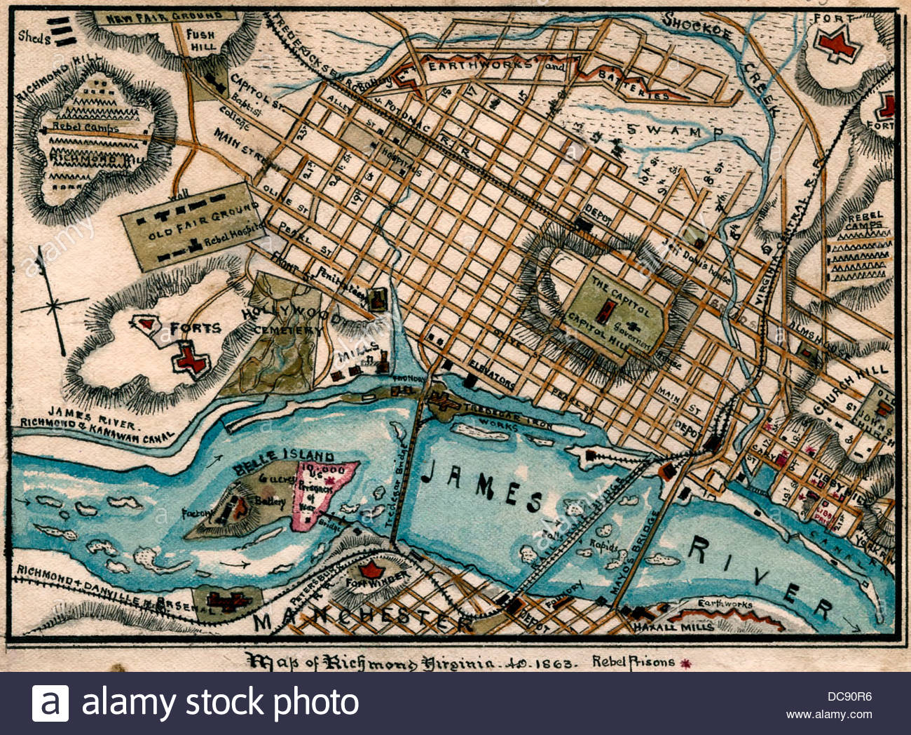
Something like this but with P.D landmarks as well
Portland 3
- Views of the City: This section expands on the idea of psychogeography through the popular reimagining’s of certain areas of Portland. Depending on the environment, certain senses and impressions are imprinted in us. For example, neighborhoods and districts such as west of the Willimete River generate a more positive buzz, while the east side is commonly viewed as dull and isolated. People often generalize an area together based on its location and proximity to other areas despite being completely different in reality. As a result, these preconceived notions impact the way one views an area.
- Third Graders Illustrate the City: Most people tend to link an area with a distinct building or feature to distinguish it from others. This section portrays the characteristics most people associate Portland’s topography by and the features that left the strongest imprint on the city’s people.
Portland seems to be a very family friendly, suburban area. Some of the more common stores such as Wendy’s, Starbucks, and Target give the impression that certain areas are pretty gentrified. This shouldn’t be surprising as it ranks the 6th whitest city in the U.S. However, other features such as the race track, Voodoo doughnuts, and the Rose Garden contribute to the city’s hipster and outdoorsy vibe. Furthermore, given that this is taken from a child’s perspective, Portland definitely has a wide array of entertainment options.
Title: Richmond More or Less
Similarly, a mental map would be ideal in portraying the most prominent and distinguishable characteristics of Richmond. The city is very diverse, from the family friendly neighborhood, Carytown, to the downtown district that hosts it’s famous “First Fridays”. The map would be useful in determining which part of Richmond sticks out to most people and leaves the strongest impression. The map will display Richmond’s topography according to my interpretation. The UR campus will be my starting point as I begin to plot the other areas around it. To the NW from there is the heavily gentrified area of Short Pump where I would depict the movie theater and mall. To the SE is the quaint neighborhood of Carytown where I would draw the local hipster shops and restaurants like Shnydigz and Carytown Burger and Fries. Further SW is the downtown district where I would draw the health center where I intern and UR downtown. Further south from there is the James River and the Brown Island- my favorite place.
Portland 4
- Social Relations: This section explains the social dynamic between the inhabitants of Portland (government, residents, and the different races). Banis and Shobe depict the actual reality between the people of the city: the increasing surveillance on the streets, the overestimated green impact, the neglect of its homeless, and the gentrification of black neighborhoods. It is easy to idolize a city such as Portland from afar: its eco-living, the friendly people, and a general countercultural movement, but it’s these relations within the community that puts the truth into perspective.
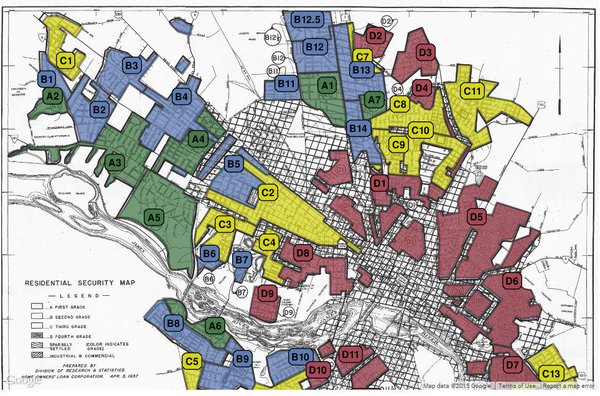
- Redlining and Gentrification: Redlining is a very prominent issue in the Richmond area. There are still many areas in Richmond that are predominantly black because of redlining. It not only impacts the living condition of its inhabitants, but also tied to educational opportunities and job access. From my short time in Richmond, I have learned of the flawed Richmond Public Schools and the faulty transportation system. Both issues are centered around the limited neighborhoods accessible to the black population. Redlining creates a slippery slope for African Americans and only continues to contribute to racial inequality.
Portland remains a very gentrified city and can still improve on reducing its racial gap. It doesn’t come as a complete surprise because Banis and Shobe have hinted that the Cascadian city and its beautiful outdoor scene tends to attract upper-class white residents. Furthermore, Portland ranks the 6th whitest city in the U.S which gives the connotation that racial equality is not a priority and that African American residents are often left behind. Only once Portland acknowledges the severity of this issue and not brush it off like with their homelessness situation, will they be able to progress.
- Title: Richmond’s Racial Gap
I would create a map that represents the housing disparity between African Americans and other races in Richmond. There is still a high concentration of predominantly black neighborhoods within the city. The map would portray the widely separated racial neighborhoods between African Americans and Caucasians. The east side of the city will be highly colored to represent the higher concentrations of African American residents due to redlining practices in the past whereas the west side will be lightly colored to represent the Caucasian dominant gentrified areas of Richmond.
More or less what I had in mind