Section 1
- Geographic concept of ‘place’
A place is an area that has unique characteristics that define it. These attributes could be as a result of natural and/or human influence.
This summer I was in Richmond.
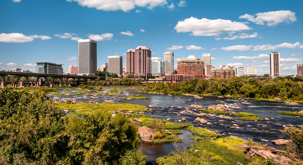
Richmond has unique attributes such as forests, the James River, Appomattox River, rolling hills, all which were naturally formed. There is also infrastructure and settlements which are as a result of human influence.
- Matched preconceived notion of Portland
- I always envisioned Portland as a green city that was very conscious of the environment. I was therefore not surprised to learn about Portland’s energy conservation strategies.
- I always imagined Portland as an agriculturally viable region. I was therefore not surprised to learn of the farm markets in Portland.
Did not previously associate with Portland
- I have always thought of Oregon as a conservative state. I was therefore surprised to learn of the liberal freedom in Portland such that there is a vibrant LGBTQ community, and people are relatively free and safe to express their sexuality.
- I had never associated Portland with the high number of breweries that characterize it.
- Why Cascadian City?
The authors wanted to avoid the conventional and often stereotypical attributes which people associate with a place due to its location in a particular region. As a result, the authors wanted to use a better way to portray Portland’s uniqueness.
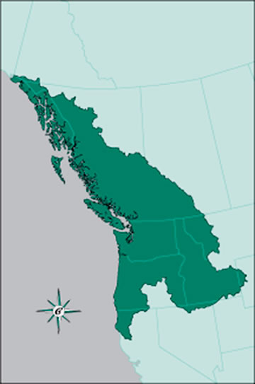
Cascadian City?
A Cascadian City means being part of a bioregion, which is a region not defined by existing political state or provincial boundaries but rather by proposed boundaries due to common characteristics such as watersheds, soil and terrain.
- Essence of Portlandness
To show people’s perspectives about the city of Portland. This includes attributes either stereotypical or factual that people associate with Portland.
Maps have great power that help structure how people see places. In Portlandness especially, maps have a visual appeal that powerfully displays a particular notion and show how ubiquitous the notion is.
Section 2
Urban Landscapes
This section aims to redefine our skewed interpretation of the word landscape by examining the setting of Portland and its neighborhoods from many unconventional perspectives. For a long time, people only associated landscape with natural settings, and as a result failed to recognize the intriguing stories that pastoral and urban landscapes reveal.
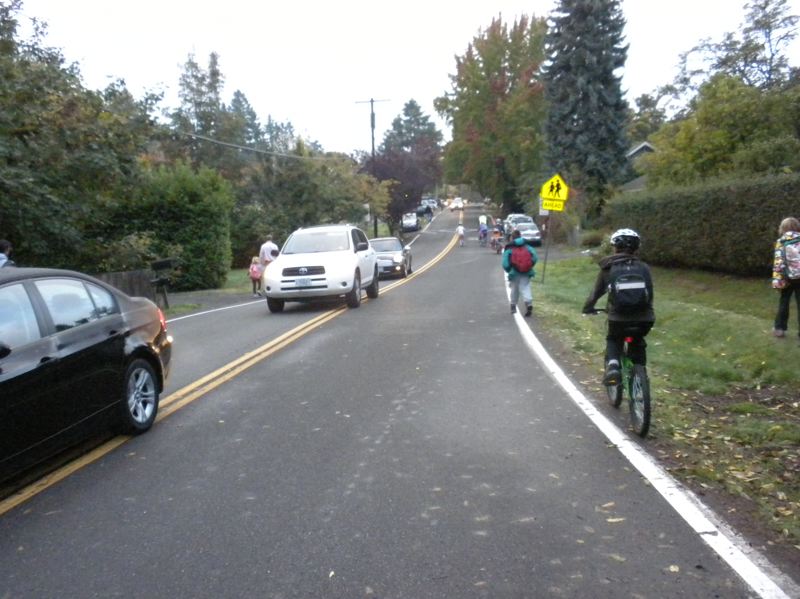
Perspective chosen: Where the sidewalks end
Why? Given the information I gained from the introductory material on Portland’s robust carless commuting and energy conservation, I was interested in finding out how the people conveniently get their way around the city.
Describe Portland according to this perspective: A significant number of roads lack sidewalks. Pearl District in particular either has dead-end walking paths, sidewalks reclaimed by vegetative growth or no sidewalks at all. Some of the neighborhoods lack sidewalks too.
What map of Richmond to represent this concept? I would design a map to show availability of sidewalks in the city of Richmond. Unlike the city of Portland that has a robust public transport system, Richmond has a menial public transit system since most of the people commute using their own vehicles.
Title of the map: An all driving city?
The map would probably not look any significantly different from that of the city of Portland. Most roads in the central district and downtown Richmond would probably be lacking sidewalks due to the huge number of people who use their own vehicles to commute.
The once and future city
This section aims to explain how the city of Portland has progressed from its ancient times and how such change has contributed to the present outlook of the city. The authors examine the elements of the city that are no longer present or never came to be. For the missing elements of the city, the authors invite us to imagine and engage with the past in trying to discover what role such elements played in defining the present Portland.
Perspective chosen: Ethnic Imprints
Why? This perspective seeks to explore the effect of the different ethnic groups of early settlers on the present outlook of the city. These immigrants caused major ethnic segregation in Portland in the early 18th century.
Describe Portland according to this perspective: Despite the huge levels of ethnic segregation that were caused by the early European settlers, Portland has progressed to be an all-inclusive city. Much of the early immigrant groups are absent from the contemporary landscape and very little remains of Portland’s European immigrant neighborhoods compared to the cities on the East coast.
What map of Richmond to represent this concept? I would create a map that shows the effect of race relations on the settlement patterns in the city and the neighboring areas. Much of the city is still racially segregated.
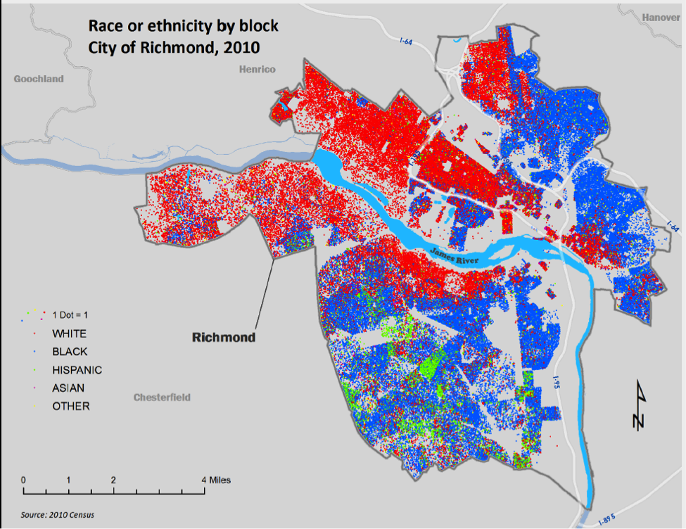
Title of the map: Racial Divide
How the map would look like: The map would portray a huge disparity in settlement patterns which are largely influenced by racial affiliations. Eastern sections of the city would show an immense number of African-American residents which is largely due to the historic red lining practices, while the west side would be predominantly white.
Social Relations
This section aims to explore the relationship between people and people, people and authorities, and people and ideas. Some of these relationships both historical and contemporary are sometimes very noticeable to people and invisible to others too. The authors hold the view that by examining the relationships that are often hidden, provide particularly useful glimpse at perspectives of a place different from our own.
Perspective chosen: Mission Invisible- The path of least surveillance
Why? I was particularly interested in finding out how the city of Portland was able to maintain very low incidences of crime. It was interesting to note the huge reliance on surveillance cameras in the city.
Describe Portland according to this perspective: There are many surveillance cameras in the city of Portland such that the authors coin the title ‘the path of least surveillance’ implying that whichever route one takes in the city, there is a likelihood that one is being monitored. A huge concentration of the security cameras are in the central district area with 400 of them also discernible focused on streets in downtown Portland. There are also more surveillance cameras at ATMs and others which are hidden.
What map of Richmond to represent this concept? I would design a map that shows the distribution of security cameras in the city of Richmond and its environs. With Richmond ranking as one of the cities in the US with moderate to low incidences of crime, it would be interesting to find out if the low incidences are as a result of the presence of many surveillance cameras.
Title of the map: A watchful city?
How the map would look like: The map would probably show fewer surveillance cameras compared to those in Portland. With the modest levels of crime in Richmond, there would be no need to have numerous surveillance cameras. The map would therefore show Richmond having a more robust police department for supplementary surveillance.
References:
https://www.google.com/search?q=sidewalks+portland+oregon&biw=1093&bih=458&source=lnms&tbm=isch&sa=X&ved=0ahUKEwiqoMLj8tPOAhUIbR4KHfKKDUEQ_AUICSgE#tbm=isch&q=racially+segregated+housing+in+richmond+VA&imgrc=MwAwIDdxpYGQ0M%3A
https://www.google.com/search?q=sidewalks+portland+oregon&biw=1093&bih=458&source=lnms&tbm=isch&sa=X&ved=0ahUKEwiqoMLj8tPOAhUIbR4KHfKKDUEQ_AUICSgE#tbm=isch&q=cascadia&imgrc=Xl_iLJ9ADrQshM%3A
https://www.google.com/search?q=sidewalks+portland+oregon&biw=1093&bih=458&source=lnms&tbm=isch&sa=X&ved=0ahUKEwiqoMLj8tPOAhUIbR4KHfKKDUEQ_AUICSgE#tbm=isch&q=richmond&imgrc=Xp3w862FrKuuQM%3A
Michael,
I chose to blog about Ethnic Imprints in Portlandness, too. It amazes me that Portland was once flooded with European immigrants in the late nineteenth and early twentieth centuries, but fails to represent any significant diversity today. If many east coast cities, such as Boston, New York and even Washington DC, have retained strong ethnic influences from around the globe, why do you think Portland is so vastly different in this sense? To what extent does this lack of diversity affect the Willamette and its watershed? Additionally, how does Richmond’s ethnic landscape, with blocks of distinct races as shown by your map, affect the James and its watershed?