Teaching Life Science with Children’s Literature: In the Trees, Honey Bees

honeybeescanned.jpg


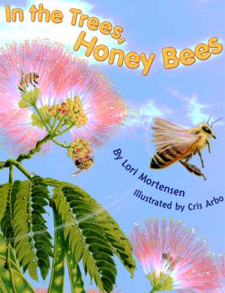
 In the Trees, Honey Bees written by Lori Mortensen and illustrated by Cris Arbo is an amazingly illustrated story about the jobs of honey bees and their interaction with the surrounding environment.  In the Trees, Honey Bees offers explanations of the different roles of honey bees such as worker, drone and queen.  One of the best aspects of this book are the illustrations, they are detailed and offer the reader a glimpse inside the hives of honey bees.  The last two pages of the book present a more elaborate account of the honey bee both inside the hive, and out.

Curriculum Connections

 There are numerous different lessons for which In the Trees, Honey Bees can be used.  It can be used for instruction on habitat, animal life cycles and behavioral adaptations to environment.(2.4a)  This book is appropriate for many different grade levels.  It provides students with an example of how animals rely on their environment to survive.(1.5a)  It would be perfect for a lesson on conserving resources and our own relationship with the environment.

Additional Resources

  • Tales from the Hive, this is a great PBS site about the anatomy of a honey bee hive and it also explains how bees dance.
  • The National Honey Board, this website has some great free downloads and a teacher’s guide for sale at a discounted rate for educators.
  • Honey Bee Lesson Plan, detailed lesson plan that discusses honey bee biology, pollination, pheromones and the “waggle” dance.

Book: In the Trees, Honey Bees
Author: Lori Mortensen
Illustrator: Cris Arbo
Publisher: Dawn Publications
Publication Date: 2009
Pages: 29
Grade Range: 1-3
ISBN: 978-1-58469-114-3

Posted in book review, life science | Comments Off on Teaching Life Science with Children’s Literature: In the Trees, Honey Bees

Teaching Geography with Children’s Literature: Maps and Mapping

Maps and Mapping

"I can’t imagine life without maps.
How would we find our way around the world?”

Introduction and Summary
Maps and Mapping, by Jinny Johnson, is an inside look at how we make and use different kinds of maps.  The book follows a fictional cartographer named Suki West, who wants to share her love of maps and globe with the readers.

The book takes us through the history of maps, why we need maps today, and teaches us how to use different types of maps.  Readers learn about the first maps, mapping the world, the difference between flat maps and globes, the difference between political, physical, and informational maps, mapping mountains, oceans, and even space!  Spread throughout the book are flaps and fold-outs that are very information and the kids will absolutely love.  (Careful here, some of the flaps are a little tricky, so it might be smart to show the kids how to fold and unfold them first).

Curriculum Connections
This book is a good way for students to learn about reading and using maps.  The students will develop map skills and learn to recognize basic map symbols, including references to land, water, cities, and roads. (VA SOL 1.4)

Followup Activity:  Have the students build both a physical and political map of their street, or the school playground, with cardinal directions included.  You can also show the children how to determine cardinal directions using the Sun and/or a compass.

Additional Resources

  • Kids can play this USA Map game.  They will place each state in its correct location as quickly as possible.
  • The students can also use Google Maps to help them locate places and use as a reference for building their own maps.  Make sure to show them how to go back and forth between political and physical maps.
  • This National Geographic for Kids game is a fun way to use and build their Geography knowledge.

Book: Maps and Mapping
Author/Illustrator: Jinny Johnson
Publisher: Kingfisher
Publication Date: 2007
Pages: 32 pages
Grade Range: 1st through 3rd
ISBN:
978-0-7534-6062-7

Posted in book review, geography | Comments Off on Teaching Geography with Children’s Literature: Maps and Mapping

Teaching Ancient Civilizations with Children’s Literature: Tales of the Dead: Ancient Egypt

Introduction and Summary

“In a world full of traitors and thieves, who would you trust?”  This is not your typical overview of ancient Egyptian civilization!  The book Tales of the Dead:  Ancient Egypt written by Stewart Ross and illustrated by Inklink and Richard Bonson deftly incorporates a mini-graphic novel into a factual overview with the exceptional detail you would expect of a Dorling Kindersley book.  Geared for older readers, this blend of historical fiction with a non-fiction encyclopedic approach helps to capture young readers’ imaginations.  It allows them to envision themselves living in ancient Egypt in a fresh, new way.

The introductory pages set the historical context for the characters of the mini-graphic novel in the book.  Methen, a boy scribe, and Madja, a serving girl in a nobleman's court, happen upon tomb robbers, and get caught up in a plot of courtly intrigue, ultimately meeting the pharaoh herself, Sobekneferu.  Their story is told in strips along the edges of the book pages, which serve to add more concrete historical information to the plot developing in the fictitious storyline.  Different aspects of ancient Egyptian civilization are discussed along the way to give readers a better understanding of Egyptian society and religious life.  Cross-sections of pyramids, town dwellings, drawings demonstrating the various steps of the mummification process, and other richly detailed pictures provide greater insight and cultural context for the story unfolding in the marginalia.  In so doing, this book makes learning about life in ancient Egypt more dynamic for young readers and forges a more personal connection to the factual material presented.

Curriculum Connections

While not really suitable for a read-aloud book for the class, this would be a great book to make available to second grade students studying ancient Egypt.   It would be a good addition to a classroom reading center where students could spend time with the book, or it could go home with students if teachers have a book borrowing system in the classroom.  A map at the beginning of the book shows the geographic location of the ancient Egyptian civilization (2.4a), and subsequent pages elaborate more upon its cultural significance, architectural contributions, religious customs, and life along the Nile River (2.1, 2.4b).

Additional Resources

General Information

Posted in ancient civilizations, book review, history | Comments Off on Teaching Ancient Civilizations with Children’s Literature: Tales of the Dead: Ancient Egypt

Teaching Geography with Children’s Literature: The Armadillo From Amarillo

0152003592.jpg
“An armadillo from Texas wondered,
“Where in the world am I?
What’s out beyond these tangled woods?
What’s out beyond the sky?”

Introduction and Summary
The Armadillo From Amarillo
 by Lynne Cherry is a beautifully illustrated tale of an armadillo’s journey around Texas hoping to discover more about where he is through a world perspective.

Sasparillo the armadillo lives in Texas, longing to discover his place in the world and the surrounding environments he has never seen. The curious armadillo witnesses some of the cities, historic sites, wildlife, and geographic features of Texas on his travels.  His eagle friend teaches him the meaning of terms such as city, state, country, continent, earth, and planet. There are also a multitude of beautiful oil pastel/watercolor scenes of maps, the environment, and Earth!

Curriculum Connections
This story is a great introduction to maps with its pictures of many perspectives and variations (physical/climate/political). The students will be able to recognize basic map symbols and reference land, water, cities, and roads. The student will also describe how location, climate, and physical surroundings affect the way people live, including their food, clothing, shelter, transportation, and recreation. (SOL 1.4, 1.5, 1.6)

Fun Activity:  Have the students construct a simple map of a familiar area such as the school yard, using basic map symbols and a map legend!

Additional Resources

** The back of the book contains an excerpt all about armadillos! For those of us who haven’t grown up around the Texas area, this is a great resource to provide students with information about this unique animal!

Book: The Armadillo From Amarillo
Author/Illustrator: Lynne Cherry
Publisher: Harcourt Brace & Company
Publication Date:
1994
Pages:
28
Grade Range:
1st through 3rd
ISBN:
 0-15-200359-2

Posted in book review, environment, geography, social studies | Comments Off on Teaching Geography with Children’s Literature: The Armadillo From Amarillo

Teaching Geography with Children’s Literature: Listen to the Wind

“We are the children of Korphe.

Not so long ago we had our lessons outside.

We learned to write with sticks, on the ground.

But then Dr. Greg came to our village,

and he listened to the wind…”

Listen to the Wind, by Greg Mortenson, is a beautiful true story of a man who lost his way on a climb of K2 in Pakistan, but was rescued and nurtured back to health by the people of the Korphe village.  Mortenson knew he had to give something back to the people of Korphe so he asked the village wise man what he should do, the wise man told him “Listen to the wind” and when he did Mortenson knew what he needed to do…

The story Listen to the wind is told from the children of Korphe’s point of view. It is a very inspiring story of one mans gratitude and a villages strength to work together. The illustrations in the book are by Susan L. Roth. When making her collages she uses materials just like the women of Korphe do to make their clothing. Roth’s collages alone tell such a heart warming story.

At the end of the book there is a collection of photographs of the villagers journey through this story. It allows readers to see how true the story really is and it gives readers more insight to how the people of the Korphe village look and where they live.

Children of all ages will enjoy the story of hope and courage in this book. As students get older they can read the young reader’s version Three Cups of Tea: One Man’s Journey to Change the World…One Child at a Time or the adult version Three Cups of Tea: One Man’s Mission to Promote Peace, One School at a Time.

Curriculum Connections
Listen to the Wind
is a great book that can be used in multiple areas of education. There are so many lessons being taught in this story from the one that Dr. Greg learns about giving back to those that help you to the lesson of community and how working together can accomplish some wonderful things. This book is a great tool to introduce China and the mountains that separate it from Pakistan (Geography 2.4). There is a great lesson in cultural differences and in economics with showing how different cultures have different wants and needs (Economics 2.9) The book can be used in an art class to show how everyday materials can be used to make beautiful clothes just as the people of Korphe do. There is a strong message of community service and a good way to introduce different charities like Pennies for Peace (Civics 2.10c). Listen to the Wind is a true story and it can be used in a language arts lesson to talk about the differences between non-fiction and fiction. The book is written from the eyes of the children of the Korphe village and this can be used to have students write their own stories.

Additional Resources

  • Pennies for Peace Here students can learn about the charity and how each penny can make a big difference in another students life.
  • At Kids Around The World students can connect to kids in other countries and learn more about their culture through games, songs and other activities.
  • Visit Yahoo kids to find a great website that gives facts that students would want to know about Pakistan and any other country they would want to learn more about.

General Information

  • Book: Listen to the Wind
  • Author: Greg Mortenson and Susan L. Roth
  • Illustrator: Susan L. Roth
  • Publisher: Dial Books For Young Readers
  • Publication Date:2009
  • Pages: 32
  • Grade Range: K-3
  • ISBN-10: 0803730586
  • ISBN-13: 978-0803730588
Posted in book review, geography, nonfiction, social studies | Comments Off on Teaching Geography with Children’s Literature: Listen to the Wind

Teaching Geography with Children’s Literature: Maps Getting From Here To There

images2.jpg

Maps Getting From Here To There  by Harvey Weiss explores maps in 10 small chapters. The introduction begins by showing how simple a map can be and expanding out into the more complex maps. The explanation of directions is awesome. It is in chapter 1 titled, “Which Way?”.  ” One of the most important things a map can do is help you get where you want to go.”.  As a student, I always want to know why I am learning something and this was a perfect explanation of the importance of map skills. In this chapter it also goes on to explain the location and significance of the compass rose.

The author breaks down the book into chapters explaining the different types of maps and the how each part of maps are important. In the chapter on topographical maps, the author introduces the vocabulary in a logical way that relates to how it is used in reading the map. This would be a great way to introduce the vocabulary in a simplified matter instead of straight definition writing.  Chapter 5 , “All Those Lines”, talks about longitude and latitude and provide excellent explanations on how those work.  ” The horizontal lines are called latitudes, and the vertical lines are called longitudes. The purpose of these lines is to help locate places on the surface of the earth.”  The last few pages of the book provide the reader with a step by step way to making their own map. Overall, this book is great and could be used for both younger and older students.

Curriculum Connections
This book could be used as great introduction to different concepts of maps. In first grade (SOL 1.4a,b and c , 1.5 and 1.6),  students need a basic understand of map symbols and cardinal directions. The beginning of the book focuses on these skills and would provide a teacher with another way of presenting the information. In second and third grades, ( SOL 2.5a and b and 2.6 ; 3.5a, b and e and 3.6), students begin actually plotting and using the maps more in depth. This book could serve as review of basic map skills and then introduce the harder concepts of maps. The book even has some crossover into the US history (US I.8a and b) with the discussion of Lewis and Clark and their exploration and mapping of America.  The language used in the book is simple enough for a first grader to understand and would still hold the attention of an older student.

Additional Resources

  • National Geographic provides several ideas for lesson plans from K-12 in the subject of geography.
  • This page provides a lesson on Orienteering , which makes map reading into a game.
  • Mr.Donn’s Page provide several ideas for lessons on map skills and even provides games for children to play online.

Book: Maps Getting From Here To There
Author:
Harvey Weiss
Publisher:
Houghton Mifflin
Publication Date:
1991
Pages:
64
Grade Range:
9-12 year old reading level
ISBN:
0395720281

Posted in book review, geography | Comments Off on Teaching Geography with Children’s Literature: Maps Getting From Here To There

Teaching Life Science with Children’s Literature: Are You a Ladybug?

 ladybug-cover.jpg

Are you a ladybug? written by Judy Allen and illustrated by Tudor Humphries takes us through the life cycle of a ladybug.  Allen begins by showing us what a ladybug’s parents look like.  She then goes on to tell us that the mother lays eggs, the babies inside grow and then brake out.  At this point they may wonder if they are ladybugs because they don’t look anything like a ladybug.The babies are not the same shape or color as their parents.  As time goes on, the babies eat and grow.  Their skin becomes tight, it cracks and they wriggle out of it.  They do this over and over again until they finally emerge as the same shape as a lady bug but very pale and with no spots.  “Slowly, slowly, slowly, your color grows stronger.  Your black dots appear.  Congratulations, you’re a ladybug!”

Curriculum Connections
This book would be a fun resource to use when introducing life cycles to students and for teaching students that not all babies resemble their parents when they are born.  Many children know that butterflies start out as caterpillars and that frogs start out as tadpoles but I bet that most of them don’t know that a ladybug doesn’t start out as a ladybug.  It would be interesting to show pictures of a few baby insects (including a ladybug) and animals to the class and ask what they will grow up to be before reading this book.    With younger children the book would be used to show that animals need to eat to survive, that they change as they grow and have varied life cycles.  It would also be used to teach students that offspring of animals are similar but not identical to their parents.  (VA SOL K.7 a, c,d).  It could be used with older students to teach that animals undergo a series or orderly changes as they mature and grow (VA SOL 2.4 a).

Additional Resources

  • This  lifecycle page contains the pages to create the lifecyle of a ladybug book.
  • This  sequencing page contains a useful assessment activity.
  • This butterfly lifecycle mobile looks like a fun craft.  It shows the complete metamorphosis of a butterfly from egg to larva (caterpillar) to pupa to adult (the butterfly).

Book: Are you a ladybug?
Author: Judy Allen
Illustrator: Tudor Humphries
Publisher: Kingfisher
Publication Date: 2000
Pages: 31 pages
Grade Range: K – 2
ISBN: 9780753452417

Posted in book review, life science | Comments Off on Teaching Life Science with Children’s Literature: Are You a Ladybug?

Teaching Geography with Children’s Literature: Where Do I Live?

where do i live image

In the book , Where Do I Live?,  written by Neil Chesanow and illustrated by Ann Iosa, the reader goes on an adventure that starts in his bedroom and leads into the great universe.   Chesanow expands on the reader’s concept of the world by moving outside of the bedroom to the house to the neighborhood to the state and eventually into outer space.  With the turn of a page, the reader can get a bird’s eye view of the world around him.  I especially like the way Chesanow starts the reader with what he can see everyday, like his bedroom, his house, and his street.  Then Chesanow takes the reader higher to view the neighborhood, city, state, country and world.  Making the connection of each smaller part to the larger world should help kids see how maps and the globe represent real images on Earth.  The words start basic and the pictures are clear.  “You live on a special piece of land.  Do you know what land is?  It’s the stuff you walk on.  It’s the ground.”   New words for kindergarten or 1st grade students might be neighborhood, city, suburb, country, state, continent, solar system, galaxy, and universe.  After taking the reader into outer space, Chesanow guides the reader slowly back to home, making a perfect review of the concepts just introduced.

Curriculum Connections
This book is ideal for grades K-1st with the introduction of map concepts and vocabulary such as country, state, and continent.  This book shows how each person is part of a neighborhood, city, state, and world all at the same time.

Where Do I Live? can be used to introduce students to maps, a round Earth, and land.  The book shows maps representing large land masses and objects from above.  Readers will be able to see where they live compared to where people from other states, countries, and continents live (VA SOLs K.4, K.5, and 1.4).

Additional Resources

  • The song Where Do I Live? and other geography songs can be used to reiterate the concepts of maps, regions, and communities that were introduced in the book as well as to teach other map terminology.
  • For hands on fun, have students try out their own map drawing skills.
  • The website for free world maps and US maps provides individual paper maps for students to color and label.

Book:  Where Do I Live?
Author:  Neil Chesanow
Illustrator:  Ann Iosa
Publisher:  Barron’s Educational Series
Publication Date:  1995
Pages:  48
Grades: K-1
ISBN: 0-8120-6541-7

Posted in book review, geography, nonfiction | Comments Off on Teaching Geography with Children’s Literature: Where Do I Live?

Teaching Geography with Children’s Literature: Roughing It On the Oregon Trail

roughing-it-on-the-orgeon-trail.jpg

Set in 1843, Roughing It on the Oregon Trail, written by Diane Stanley and illustrated by Holly Berry, is based on the 5 month 2,000 mile journey on the Oregon Trail.  The story starts off with twins, Lenny & Elizabeth going back through time with their grandmother, and her magic hat that takes them back to 1843.  Once Lenny, Elizabeth & their grandmother arrive in the Louisiana Territory, they head off looking to meet the twins great-great-great-great grandmother, Elizabeth.  The children learn what it was like traveling along the Oregon Trail.  Descriptions are given about traveling in the covered wagons, the hot and dusty atmosphere, the food that was cooked, the oxen & the Indians they would meet along the journey.

Curriculum Connections
This is a wonderful book with detailed descriptions on every page.  I would recommend reading this book to students in a Virginia 5th grade classroom when learning about the Oregon Trail and the Westward Expansion.  Reasons for the westward expansion are explained (Panic of 1837 when a lot of people lost the farm that they called home/depression) along with the hopes and adventures of moving out west (SOL USI.8).  Stops made along the journey include historic sites such as: Scott’s Bluff, Chimney Rock, Independence Rock, The Great Plains, Snake River, Columbia River and many more.  The early encounters with Native Americans are explained: events such as the leader of the camp smoking the clay pipe with the Indian Chief and the leader of the camp giving up dried buffalo meat to the Native Americans (SOL USI.2 & USI.3).

Additional Resources

  • Oregon Trail map of 1843 has landmarks that can be selected for any additional readings and photos.
  • Oregon Trail Lesson Plan will help students become familiar with the geography of the land along the Oregon Trail by using teamwork and cooperation.  This will also introduce students to basic navigation. *The first 3 resources are free, after that the user will need to pay a subscription fee.
  • The Oregon Trail gives detailed information about the Oregon Trail in the following categories: historic sites along the trail with pieces of information about each location, interesting facts and games there were played, diaries that were kept along the trail & a shop where teachers can purchase items to aid in the lesson plan.

Book: Roughing It On the Oregon Trail
Author: Diane Stanley
Illustrator: Holly Berry
Publisher: HarperCollins Publisher
Publication Date: 2000
Pages: 40
Grade Range: 4-5
ISBN: 0060270659

Posted in book review, geography, history, social studies | Comments Off on Teaching Geography with Children’s Literature: Roughing It On the Oregon Trail

Teaching Geography with Children’s Literature: Travels with Charlie: Way Down South

Down South, A Search & Find Geography Book

“If you follow Charlie
from state to state,
you’ll see the whole South.
Now, won’t that be great?”

Travels with Charlie: Way Down South, A Search & Find Geography Book, written by Miles Backer and illustrated by Chuck Nitzberg, presents geography and facts about states in the American South in a visually exciting way.  The book begins with a poem, introducing readers to landmarks they’ll see as they “travel” with Charlie, a lovable dog with a red bandanna, through the South.  The book then presents a 2-page spread profiling each southern state.  The left page has facts including State Nickname, State Capital, State flag, interesting “Did You Know…” trivia, and landmarks for readers to identify.  The right page has a map of the state along with comical but educational illustrations depicting key landmarks and state characteristics.  For example, North Carolina – The Tar Heel State – depicts the Wright Brothers Memorial in Kitty Hawk with an illustration of a plane like the one first flown there in 1903.  A picture of a dresser represents the furniture industry in High Point and students learn from the facts that there are over 125 furniture factories in the High Point area.  The “Did You Know…” facts also tell readers about Blackbeard the Pirate and the Lost Colony.  On each state page, Charlie is hidden within the map for readers to find among the state landmark illustrations.  The book concludes by asking readers to find a particular landmark on each state map page; “Can You Find…a festival in Virginia with a big, brass band…?”

Curriculum Connections

Travels with Charlie: Way Down South is appropriate for teaching United States regional geography and state facts to a variety of grade levels from Kindergarten to 5th grade.  This book is a great way to introduce students to the ideas of maps (K.4b), geographical regions, how geography influences people, places, and history (VS.1i, USI.2, USII.2), and factual information about states.  This book is part of the Travels with Charlie series which includes Travellin’ the Northeast and Way out West.  Fourth grade students studying their own state history could also use this book to compare and contrast their state to one or more of the states highlighted in the book, illustrating skills for historical and geographical analysis and good citizenship (VS.1).

Additional Resources

Book: Travels with Charlie: Way Down South, A Search & Find Geography Book
Author: Miles Backer
Illustrator: Chuck Nitzberg
Publisher: Blue Apple Books
Publication Date: 2007
Pages: 36
Grade Range: K – 5
ISBN 10: 1-59354-594-0
ISBN 13: 978-1-59354-594-9

Posted in book review, geography, nonfiction | Comments Off on Teaching Geography with Children’s Literature: Travels with Charlie: Way Down South