The foreign born population and the Latino population are two groups that don’t tend to have great access to healthcare in the United States. Some barriers that hinder these groups from accessing healthcare are lack of insurance and cost. Free clinics and federally qualified health centers (FQHCs) were established in Richmond to combat the aforementioned barriers, but they fail to address one barrier that is incredibly understated: location.

Immigrant & Latino Access to Healthcare in Richmond


21 and Over Population Affected by Disneyland Epidemic

In December 2014, a measles outbreak originated in Disneyland in Orange County, California and subsequently spread to other Californian counties until the epidemic was declared over in April 2015. Curiously, the outbreak affected more adults than babies and children, who are usually more susceptible to contracting vaccine-preventable diseases because they can be too young to be immunized against them. In total, 136 measles cases were confirmed in California, and 56% of these cases consisted of adults over the age of twenty years old. This map visualizes the correlation between the amount of adults living in Californian counties and where the outbreaks took place, and it seeks to tell the story of why more adults were affected by the Disneyland measles outbreak.

CAHerdImmunityI wanted to display the correlation between lack of vaccination and vaccine-preventable outbreaks but the data that I had did not present a correlation on my map. Because most of the affected people during the 2014-2015 measles outbreaks were greater than the age of 20, I mapped out the correlation between the measles outbreak and population over 21 and there is a correlation.

I would like to create a comparative map that displays both the rate of vaccination and the rate of vaccine-preventable outbreaks in the United States. In my previous Introduction to Health Care Studies class, I learned that there is a direct correlation between the lack of vaccination and disease epidemics. Herd immunity is an indirect way of protecting a community from diseases and occurs when a high proportion of a population is immune or vaccinated. This is especially important to protect young children, who are more vulnerable to acquiring diseases because they are too young to be vaccinated. For example, in 2015, California experienced a huge measles outbreak in Disneyland where most of the infected people were unvaccinated due to personal beliefs and young age. Maps that I have researched present the rate of vaccination and the rate of vaccine-preventable outbreaks separately, but never together, which is what I want my map to show. Since my map would have two different sets of data, I would have to display these data sets so that they are both clear and understandable, but most importantly, I would like my map to convey the message of the importance of herd immunity.

Before this class began, I had no idea that maps had the capacity “to lie.” I eventually learned that maps sometimes leave out certain aspects or distort size and scale. As we have learned over the past few classes, the ways maps “lie” have become increasingly more alarming; maps are sometimes created to serve a specific purpose, such as political propaganda for the Nazi government. Maps are created in the interests of the map creators. The Shari Motro article reveals more recent maps that have to do with a present global issue that everyone is familiar with: the Israeli-Palestinian conflict. The map that was presented in the Oslo II peace talks divided Palestinian territory into small sects and underemphasized the amount of land Israel would have under its control—all through choice of colors, labels, size, and scale. The small and slight choices on maps that I thought were insignificant during the first week of classes were extremely important in the international relations between these two conflicting countries and did not help to expedite the peace process between them. The lessons that I, as well as bigger entities like governments, can take away from the Swiss Cheese Map is to analyze maps more deeply and to not take small choices, such as color scheme and scale, for granted.

My name is Rizza Rivera, and I am a sophomore from Jersey City, New Jersey. I have lived in New Jersey for all of my life, but I attended an all-girls boarding school in Sparks Glencoe, Maryland for high school. I’m currently pursuing a Health Care Studies major. I have been involved in several cultural activities on campus: Ritmo Latino, our Latin dance group; the Multicultural Student Council, a planning committee for multicultural admission events; and Multicultural Pre-Orientation. I also volunteered with World Pediatric Project, a non-profit that provides intensive surgical care to Latin American families who cannot obtain it in their home countries. Over the summer, I interned with a non-profit called Wight Foundation, which helps inner city minority middle school students to obtain better education opportunities outside of New Jersey. This is the same program that I went through when I was in middle school to attend my boarding school in Maryland. Because I grew up and live in the inner city and have constant support from Wight Foundation, I always possessed a passion for bolstering those who are usually underprivileged—and in most cases, the underprivileged are minorities. The clubs and positions that I have historically taken—Multicultural Student Council member, Multicultural Pre-O advisor, WPP volunteer—have demonstrated my passion for bolstering those who are typically undermined and exposing these individuals to opportunity.

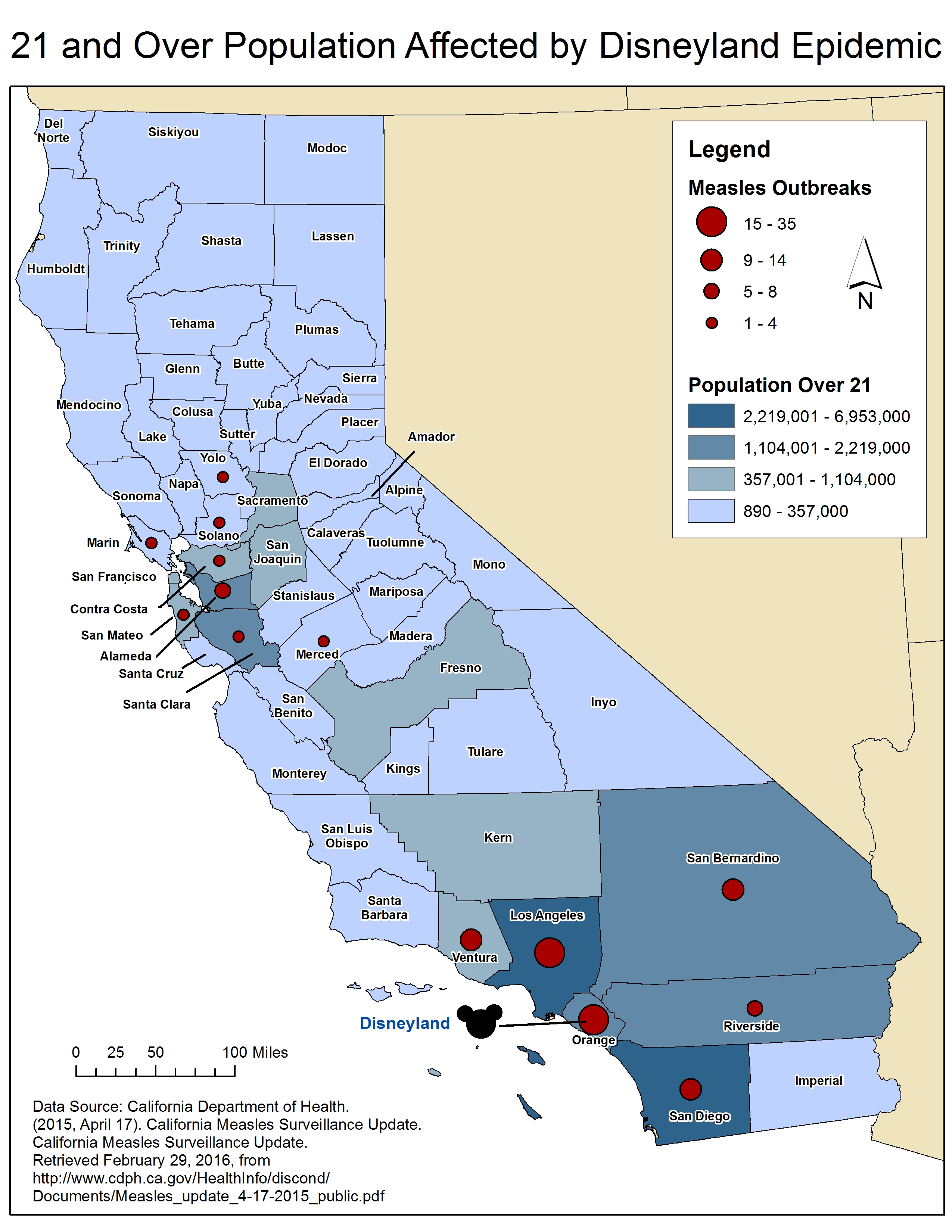
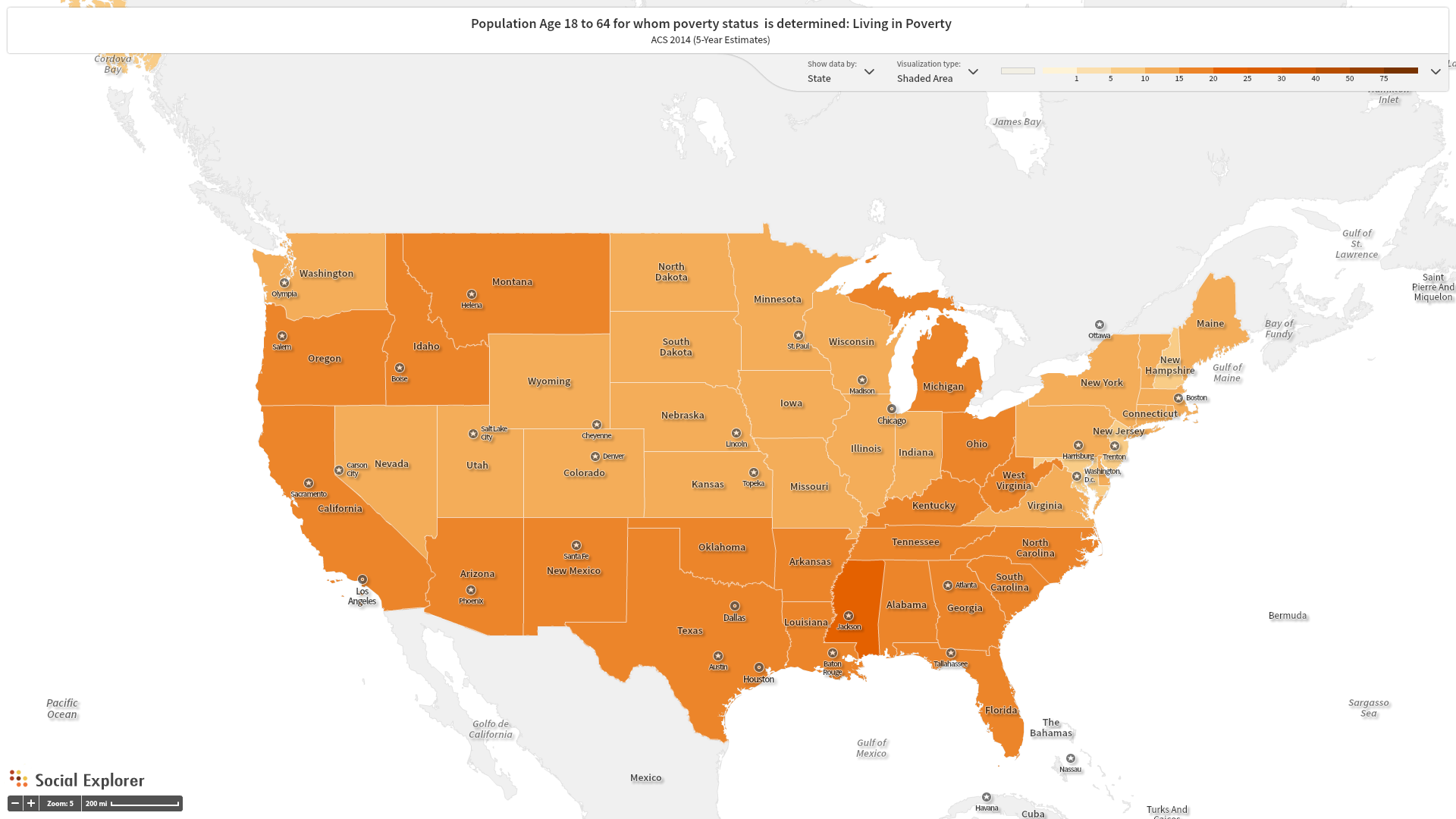
A major in Health Care Studies aligned perfectly with my passions, which is why I decided to pursue this major. This geography class, Introduction to Maps and Geovisualization, is a requirement for my major, but this class also seemed like one of the more interesting major requirement classes because I would be working with a software that is totally unfamiliar to me. Geographic Information System is used widely among public health and epidemiological professionals, so I am very excited to learn how to use a system that I might be able to use later in my professional career. I hope to use GIS in order to research some topics that are very important to me, such as minority health, environmental issues, and social problems. I have always been curious about how resources—be it medical, academic, or occupational—are dependent on place of residency, and I especially want to research why this disparity between impoverished areas and affluent communities exists. I have learned in my Health Care classes that factors like residence and environment directly affects public health, so I want to expand on what I learned and hope to learn more about how public health and geography cross paths.