Here is the link to my story map: http://arcg.is/1SsslNr
My web map is a story map of the 30 stadiums in Major League Baseball.
Here is the link to my story map: http://arcg.is/1SsslNr
My web map is a story map of the 30 stadiums in Major League Baseball.
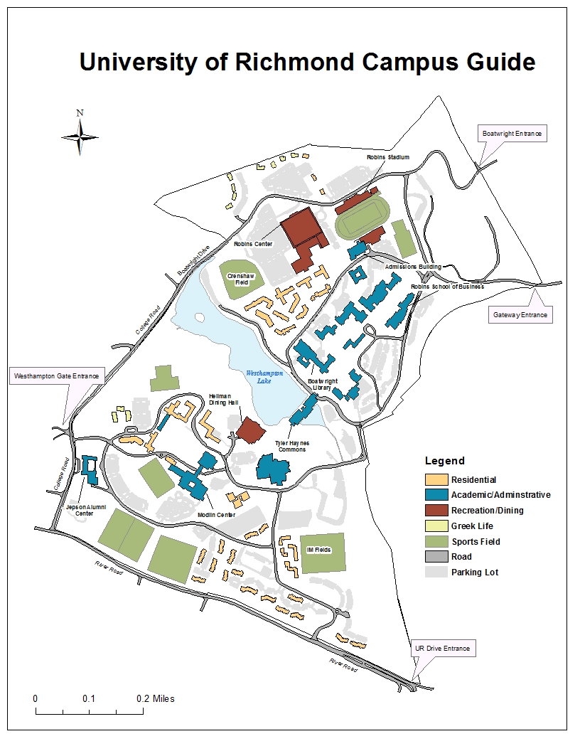
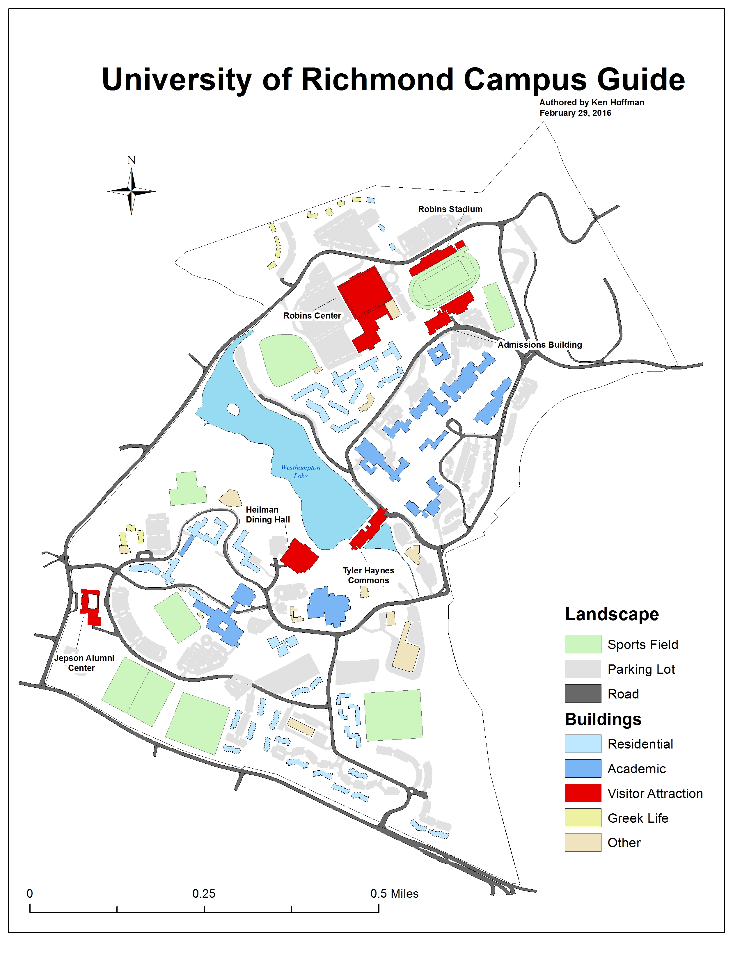
My map organizes the University of Richmond so that a visitor can easily recognize the different buildings and complexes on campus. The main entrances into campus as well as roads around campus are labeled so that a visitor can easily orient himself or herself to the campus. The main buildings and sports complexes that visitors are most likely to need to locate are labeled individually.
For my project, I would like to make a map that identifies the purpose each building serves to the University of Richmond. From studying the map in class, I’ve come to realize that there are ways to make the map more helpful for visitors and prospective students. By identifying whether a building is an academic building, athletic facility, food spot or dormitory, I can help illustrate which areas of the campus would be best for parking or tours and where one can go to eat. I am interested in making this map so that I can simplify the University of Richmond campus map. It will be a large-scale map that will help to better illustrate Richmond’s campus.
The Motro article helped open my eyes to show how important every detail is when making maps. The colors used, thickness of the border, and placenames can have a strong impact on territorial issues. The Oslo map lead to further conflicts between Palestine and Israel. The map displayed Palestine’s land in blotchy patches and the colors used caused the map to downplay Palestine’s controlled territory. This situation helped me understand how impactful a map can be. Moving forward, I need to pay close attention to the colors I use and the message that my map is sending.

This is a map that shows the percent of vacant housing units in counties throughout the United States. The darker the yellow, the higher the percentage of vacant housing units in that particular county. As you can see, the percent of vacant houses is higher in the western half of the United States.
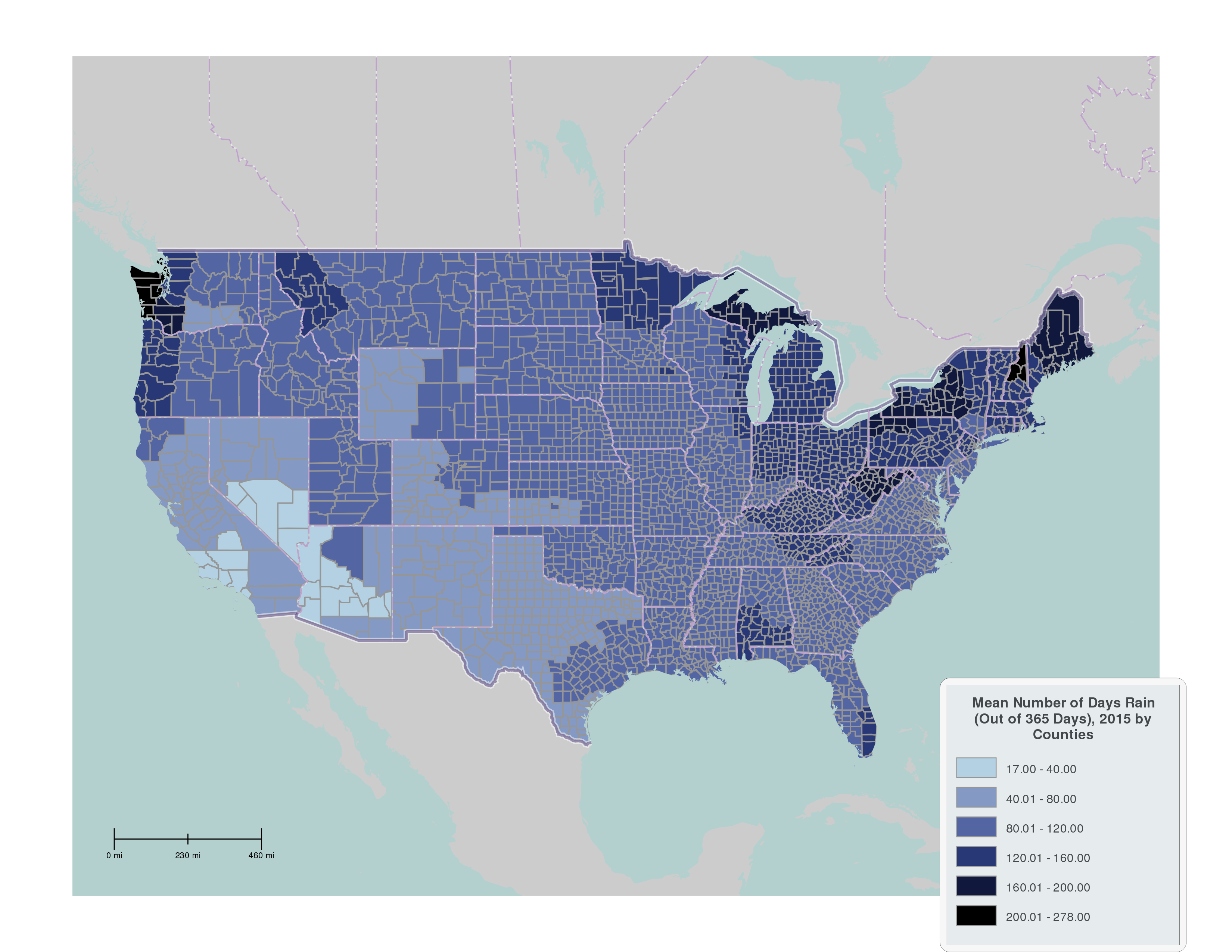
This map’s purpose is to show the mean number of days it rains in parts throughout the United States. You can see through this map that it rains the most in the northwest and northeast. It rains in Arizona and New Mexico the least.
I am a junior (obviously at UR) from Westchester, New York. My major is accounting and I am looking to add a concentration in finance. Outside of classes, I am a member of Theta Chi and Delta Sigma Pi Business Fraternity. My favorite sports are basketball and golf. Unfortunately though, I haven’t been able to golf much while at school. Over winter break, I went with my family on vacation to the Dominican Republic. It was my first time leaving the country for anywhere other than Canada in almost five years. We had a lot of fun and I got to go on a snorkeling trip one of the days.
I decided to take Maps and Geovisualization this semester because I have always been interested in maps. I used to love studying maps back in my middle school classes, but unfortunately, I have not had a class focused on the study of maps in many years. I am taking four business school classes this semester and decided that Maps and Geovisualization would be an interesting course to take outside of business. The maps that Professor Madron showed us during the first class got me very excited to create my own maps.
I feel that I enjoy maps so much because they are visually appealing. My favorite style of learning is visually because it involves using images as ways to express information.
I hope that through this class, I will gain the skills and knowledge necessary to create maps that are unique to me. I want to be able to tell a story through my own maps. I also look forward to analyzing and interpreting other maps in class.
Welcome to blog.richmond.edu. This is your first post. Edit or delete it, then start blogging!