Web Map: A Tour of the Golf Courses on Kiawah Island

Here is the link to my web/story map: http://arcg.is/1T1wtki

My web map is a story map of the seven golf courses on Kiawah Island, SC.  Each golf course is represented by a point on the map, label and picture, with a short description of each course attached to each point/picture on the story map.  Each course description also has a link to to a website where people can learn more about the course and contact the Pro Shop.

Posted in Assignment 9 | Comments Off on Web Map: A Tour of the Golf Courses on Kiawah Island

Matt and Ken Blunder’s Map

Matt and Ken map


Key:

Mixed up the campus entrance labels

Changed the units in the scale

Changed color of the lake and its text label color

Added a building that doesn’t exist

Posted in Assignment 8 | Comments Off on Matt and Ken Blunder’s Map

Final Map

Map Image_MatthewCelona


University of Richmond Visitor Campus Map: Description

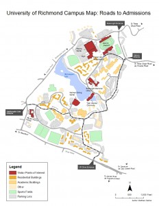
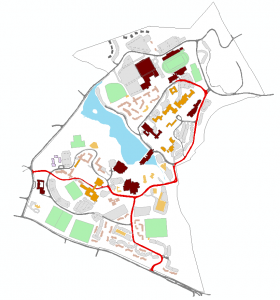
This map is made specifically for visitors to the University of Richmond campus.  It shows the most direct route to the admissions building (using arrows), where visitors meet for information sessions and tours, from each of the three direct entrances into campus.  Furthermore, the map uses a dark, bold red color, and individual labels, to show the most popular buildings (e.g. admission building, dining hall, library, etc.) that visitors to the campus want to see.  The map also uses lighter colors to group together academic buildings, residential buildings, and other buildings so visitors to campus can distinguish between some of the buildings that are not emphasized with dark colors.  Lastly, the sports fields and parking lots on campus are also shown in lighter colors to help visitors better orient themselves on campus.

Posted in Assignment 6 | Comments Off on Final Map

Project Update

Capture

Posted in Assignment 5 | Comments Off on Project Update

Project Proposal

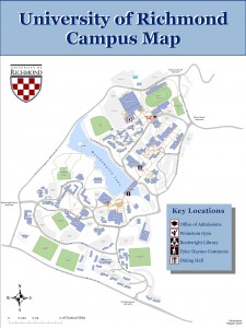
For my project, I am thinking of editing the campus map to make it one that is designed specifically for visitors to the school.  For example, I have been asked multiple times from parents driving around campus with their son/daughter for directions on how to get to the admissions building because they are coming to take a tour of the school.  My plan is to edit the campus map in a way that emphasizes specific buildings on campus that visitors usually want to see (e.g. admissions building, dining hall, business school, commons, library) and will show routes to get to these buildings.  I will still keep the other buildings and roads on the map, but my plan is to use much lighter and more transparent colors for those buildings, and use darker and bolder colors for the main buildings and routes that I want to show for visitors.  The one concern I have right now is figuring out if I will be able to change the color of specific, individual buildings without changing the color of all of the buildings at the same time.

Posted in Assignment 4 | Comments Off on Project Proposal

Motro Article Reflection

Overall, I thought the Shari Motro article about the Swiss Cheese Map was very interesting. Even though I didn’t know much about the Israeli-Palestinian peace talks prior to reading the article, I think Motro did a great job of going into detail about the talks and the influence that mapmaking can have on negotiations. I especially liked the point Motro made in the middle of page 47 on how everything you put into a map will affect the viewer’s interpretation, such as color and cropping. I also enjoyed the fact that Motro pointed out that the hardest part of mapping the agreement was how to map Area C and Motro proceeded to provide us with four different maps on how area C could be mapped. I thought this emphasized the point that as a mapmaker, your interpretation of data and the colors and symbols you use to portray that data can heavily influence the way the map is seen by the viewer. All in all, I enjoyed learning how maps can be used in peace talks and that even though it may be difficult, it is very important to make sure that those maps are designed properly.

Posted in Assignment 3 | Comments Off on Motro Article Reflection

Map #2

Map 2 export

This is a map of money spent on public transportation by county across the country, excluding Hawaii and Alaska.  I thought it made sense to see a larger amount of money spent on public transportation around larger cities in the northeast and west coast.

Posted in Assignment 2 | Comments Off on Map #2

Map #1


Posted in Assignment 2 | Comments Off on Map #1

This Is Why I’m Here

My name is Matthew Celona and I am from Summit, NJ.  I am a junior here at the University of Richmond.  I am majoring in Business Administration with concentrations in Economics and Finance, as well as minoring in Mathematics.  As a business school major, it was great to hear in our first class meeting this past Tuesday that what we will learn this semester can definitely be applicable in the business world.

Last semester, all of my classes were in the business school.  Even though I loved taking all business school classes for a semester, I wanted to add a little diversity to my schedule this semester and take a class outside of the business school.  So when I was deciding on what class that should be for this semester, I eventually chose this geography class.  I have never taken a geography class before, so that provided the original appeal for me to sign up for this class.  But there were a few other main reasons as to why I signed up for this geography class.  First, I have an older brother who loves maps.  He has a few very interesting older maps that are hanging on the walls in his apartment.  Every time I see those maps, I always take a close look at them because they just look really interesting.  So my brothers interest in maps did spark my interest in geography as a whole, which is one of the reasons I wanted to take this class.  Second, my roommate here at Richmond for my freshman and sophomore year took an introduction geography class as a sophomore and told me that he learned a ton and the class was really interesting.  So my roommate definitely influenced my decision to take a geography class.  The last reason I chose to take this class is simply because I don’t think that I am great with geography as a whole and this was a great opportunity to learn more about the subject and refine my skills in geography.  I think that learning how to read and interpret different maps and studying the history of mapmaking will be really interesting and definitely sparked my interest in this class specifically.

Because I have never taken a geography class before, I hope that this class will give me a good foundation of skills in geography as a whole that I will be able to build off of to refine those skills even further.  If I am able to learn something that I can apply to my studies in the business world, I think that will be a fantastic, but primarily, I really just want to be gain a better understanding of maps and how to interpret them.  I think it is a skill that I will be able to use for my entire life, and one that I am definitely very interested in now.

Posted in Assignment 1 | Comments Off on This Is Why I’m Here

Hello world!

Welcome to blog.richmond.edu. This is your first post. Edit or delete it, then start blogging!

Posted in Uncategorized | Comments Off on Hello world!