Author's posts
Oct 04
Student Map Competition, sponsored by Timmons Group
The Spatial Analysis Lab at the University of Richmond is pleased to announce a new Student map Competition. This competition is to promote and reward student work in the broad and interdisciplinary area of geo-visualization from students at the University of Richmond. Timmons Group, a multi-disciplined engineering and technology firm headquartered in Richmond, has generously …
Nov 12
Come Celebrate GIS Day With Us During East Asia Week!
November 12, 2019 This week the University of Richmond is celebrating East Asia Week, a cross-campus celebration of International Education Week! There are so many events on campus- what a great opportunity to learn more about global cultural, physical, and political geographies! And the most exciting part of the week? UR is hosting GIS Day …
Apr 15
2019 VAMLIS GeoCon
March 26-27, 2019 University of Richmond undergraduate students in the Department of Geography and the Environment, alongside SAL GIS Technicians and research assistants, created posters and web maps to communicate their research at the 2019 VAMLIS GeoConference. Students and SAL Interns Valerie Galati, Matthew Franklin, Griffin Walsh, and Emily Routman presented their research to GIS …
Jun 18
Kenyan Healthcare Adventure and 1st Day of Work
June 18, 2018 By Griffin Walsh ’20 A few weeks ago I was bit by a tick in Pennsylvania. After arriving in Kenya, I began to develop a rash on the exact spot where I had been bitten so I began to suspect Lyme disease. We decided I should go visit a doctor to confirm …
Jun 11
Week 2 of Crash Course: Preparing for Kenya
June 11, 2018 By Meg Carroll ’20 Jambo, it’s Meg! We’re in the midst of prepping for our trip to Kenya! This week we’ve been holed up in the SAL glued to our desktops while we’ve practiced Swahili, read about African culture, and reviewed/practiced different GIS tools. Our week has included conversations about office etiquette …
Jun 07
Week 1 of Crash Course: Kenyan Culture
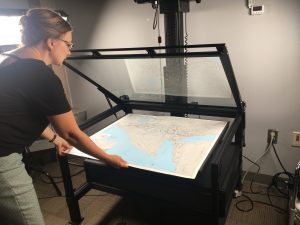
June 7, 2018 By Lauren Scheffey ’20 Today we met Kimberly Wolfe in the Digital Scholarship Lab in the library to learn how to convert physical maps to a digital form. We used the university’s high-tech, super-expensive camera and a program Kimberly called “photoshop on steroids” to take a photo of the map and adjust …
Jun 05
Summer 2018 in the SAL….and Kenya!
By Kim Browne, SAL Director The Spatial Analysis Lab has been a hub of activity since spring classes ended and we said goodbye to our graduates. Colleagues from Biology and Classics have been in and out of our space collaborating on the East End project, Rock Pools and more. Justin Madron from the Digital Scholarship …
Apr 06
VAMLIS 2018 Winners
University of Richmond students from the Advanced Spatial Analysis course took home 1st, 2nd, and 3rd place in the Undergraduate Web Map competition at the 2018 VAMLIS Virginia GIS Conference in Virginia Beach. Congratulations to these amazing students!!! Check out their web maps below! 1st: Emily Routman ’20 Immigrants account for around 17% …
Dec 13
ArcGIS Online
Want to check out many of the cool maps, applications, and story maps students, faculty, and staff have created with help from the Spatial Analysis Lab? Click the image above or follow the link below to access the University of Richmond’s ArcGIS Online Organizational Account. https://urichmond.maps.arcgis.com/home/index.html For help getting started using ArcGIS Online click …
Oct 30
How To: Download Open Street Map (OSM) Data
OpenStreetMap (OSM) is a collaborative map of the world where users can edit and update maps of their communities in real time. It was inspired by the success of Wikipedia and has quickly spread to become a force in online mapping world. While local governments in the US and other western countries are rapidly deploying …

