About the SAL

The University of Richmond’s Spatial Analysis Lab is the premier on-campus location for anything related to GIS (Geographic Information Systems). Located in room 300 of the Carole Weinstein International Center, near the Geography and the Environment Department, our hybrid classroom / computer lab contains up-to-date and complete versions of the ArcGIS software suite, as well as various other remote sensing, statistical, and design software.

The Spatial Analysis Lab is staffed by our Director, Dr. Guoping Huang, Operations Manager, Beth Zizzamia, and a team of student interns who have taken the GIS classes offered at the University of Richmond. Feel free to fill out a Support Survey for assistance with GIS or any other geospatial technology. We are more than happy to help you enhance your work, research, and projects with GIS!

Use the tabs at the top of this page to learn more about the Spatial Analysis Lab and about GIS. Follow us on Twitter @UR_SAL for news from the Spatial Analysis Lab as well as fun, geography-related links. And as always, you are welcome to stop by and visit with us. We will be sure to inspire your imagination about the possibilities surrounding GIS.

Come visit the SAL

Mission Statement

The Spatial Analysis Lab creates a working environment for students to collaboratively discover and construct knowledge as they engage in real-world projects that contribute to their campus, local and global community. Students apply geospatial technology in their coursework, innovate and collaborate with faculty researchers, university staff, community outreach groups, and one another. Our experiential, student-centered …

What is GIS?

If you’re new to GIS or you’re considering taking a GIS class here at the University of Richmond, you may be wondering what exactly is GIS. In short, a Geographic Information System is many things: people, documentation, hardware, software, and data being used together to answer two main questions: Where and Why? GIS is the …

GIS Day

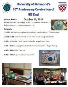
GIS Day 2017: Celebrating 10 Years of GIS Day at University of Richmond GIS Day 2016: Wednesday November 16 Join us for GIS Day 2016 as students from the Intro to GIS classes explore the Annexation of Chesterfield County by the City of Richmond in 1970, as featured in Dr. John Moeser’s book Politics of …

Student Map Competition, sponsored by Timmons Group

The Spatial Analysis Lab at the University of Richmond is pleased to announce a new Student  map Competition. This competition is to promote and reward student work in the broad and interdisciplinary area of geo-visualization from students at the University of Richmond. Timmons Group, a multi-disciplined engineering and technology firm headquartered in Richmond, has generously …

Read more

Come Celebrate GIS Day With Us During East Asia Week!

November 12, 2019 This week the University of Richmond is celebrating East Asia Week, a cross-campus celebration of International Education Week!  There are so many events on campus- what a great opportunity to learn more about global cultural, physical, and political geographies!  And the most exciting part of the week? UR is hosting GIS Day …

Read more

2019 VAMLIS GeoCon

March 26-27, 2019 University of Richmond undergraduate students in the Department of Geography and the Environment, alongside SAL GIS Technicians and research assistants, created posters and web maps to communicate their research at the 2019 VAMLIS GeoConference. Students and SAL Interns Valerie Galati, Matthew Franklin, Griffin Walsh, and Emily Routman presented their research to GIS …

Read more

Kenyan Healthcare Adventure and 1st Day of Work

June 18, 2018 By Griffin Walsh ’20 A few weeks ago I was bit by a tick in Pennsylvania. After arriving in Kenya, I began to develop a rash on the exact spot where I had been bitten so I began to suspect Lyme disease. We decided I should go visit a doctor to confirm …

Read more